- My Forums
- Tiger Rant
- LSU Recruiting
- SEC Rant
- Saints Talk
- Pelicans Talk
- More Sports Board
- Fantasy Sports
- Golf Board
- Soccer Board
- O-T Lounge
- Tech Board
- Home/Garden Board
- Outdoor Board
- Health/Fitness Board
- Movie/TV Board
- Book Board
- Music Board
- Political Talk
- Money Talk
- Fark Board
- Gaming Board
- Travel Board
- Food/Drink Board
- Ticket Exchange
- TD Help Board
Customize My Forums- View All Forums
- Show Left Links
- Topic Sort Options
- Trending Topics
- Recent Topics
- Active Topics
Started By
Message
re: Non-Political Mississippi River Question
Posted on 8/1/23 at 2:41 pm to Y.A. Tittle
Posted on 8/1/23 at 2:41 pm to Y.A. Tittle
quote:
For the most part, we have stopped the river at the eastern edge of its historical meandering - at least in the lower section.
The Mississippi Delta area is the exception.
Bingo. At least right now that's where the river is. We've built entire economies and cities based on the river's very recent position. But it's moved around over thousands of years before humans ever existed in Louisiana.
You can actually still see very obvious geographical features that indicate a former river bed way out in Opelousas. That would be in the natural delta today if not for our levees. That's how massive it is.
This is an interesting topic and it's really weird to see this if you look on a map. It makes you realize how human settlement in Louisiana was clearly just the latest blink of the eye from a geology perspective.
We've used levees to lock the river's placement in today, but without that, the channel would be shifting back west through the Atchafalaya. And probably again farther west 500 years after that. Then maybe back east after another 1,000 years. etc.
 1
1

Posted on 8/1/23 at 2:42 pm to captdalton
quote:A fair number of them were objectively wrong ("The Americans were moving West, duh." when the city was founded by the French a century before Americans reached the area), which is to be expected when asking almost any question. Several provided answers that appear to be correct, and I appreciate their input.
Multiple people have given you the reasons. Yet here you are, still arguing.
This post was edited on 8/1/23 at 3:07 pm
Posted on 8/1/23 at 2:44 pm to AggieHank86
So have you gotten an official diagnosis for what is wrong with you?
Or are you really just this big of an insufferable, unlikeable count who loves to hear they/themselves talk?
Or are you really just this big of an insufferable, unlikeable count who loves to hear they/themselves talk?
Posted on 8/1/23 at 2:45 pm to goofball
quote:Another thing I find interesting about the Mississippi is that it has not only tributaries which flow INTO it, but also distributaries which flow OUT of it and separately to the Gulf.
This is an interesting topic
I was working on a map and trying to trace the rivers. The Atchafalaya had me baffled for that reason. I know that it generally flows south to the Gulf, but I saw a confluence with the Mississippi far to the north.
This post was edited on 8/1/23 at 3:01 pm

Posted on 8/1/23 at 2:51 pm to AggieHank86
quote:
Does anyone know why almost all of the Mississippi River port cities are on the Left Bank of the river and not the Right Bank?
quote:
Posted by Message
AggieHank86

You do realize that you can travel in either direction on a river, upstream and downstream? There's a reason nobody refers to left bank or right bank, because that's all dependent on which way you are traveling. It's ok to admit when you don't know what you are talking about instead speaking/typing and taking away all doubt.
This post was edited on 8/1/23 at 2:55 pm
Posted on 8/1/23 at 2:56 pm to Y.A. Tittle
quote:
All built on bluffs opposite flood plain/farmland across the river.
Alluvial plains/natural levees.
Physical Geography 1001 at LSU.
Posted on 8/1/23 at 2:59 pm to HondaBigRed
quote:Good advice ... for you.
There's a reason nobody refers to left bank or right bank, because that's all dependent on which way you are traveling. It's ok to admit when you don't know what you are talking about instead speaking/typing and taking away all doubt.
Read the link. Hell, Google it yourself, and you will see hundreds of explanation of the Left/Right Bank usage.
"Left Bank" and "Right Bank" of a river have meanings analogous to "starboard" and "port" on a boat ... based upon facing downriver, rather than facing the bow.
This post was edited on 8/1/23 at 3:02 pm
Posted on 8/1/23 at 3:03 pm to AggieHank86
quote:
A fair number of them were objectively wrong, which is to be expected when asking almost any question
So you already knew the answers. Which would lead many to wonder why in fricks sake you would ask the question. But we know it was just so you can pontificate for now going on 4 pages. You are a joke. A sad joke that makes no one smile.
Posted on 8/1/23 at 3:05 pm to AggieHank86
quote:because slavery
Does anyone know why almost all of the Mississippi River port cities are on the Left Bank of the river and not the Right Bank?
Posted on 8/1/23 at 3:09 pm to Y.A. Tittle
quote:
The land directly across the river in Algiers is actually a bit higher.
French Quarter won out as the main early settlement area because there was high ground access to Bayou St. John (Esplanade Ridge), which provided navigable access to the Lake and then the Gulf.
Right.
Posted on 8/1/23 at 3:09 pm to captdalton
quote:No, Dalton, I did not KNOW the answer. But I DO know enough history to recognize an "answer" that was pulled from someone's arse. Claiming "US settlement patterns" as the reason for the location of a city founded a century before American expansion into that area? Clearly an answer pulled from a rectum.
A fair number of them were objectively wrong, which is to be expected when asking almost any questionquote:
So you already knew the answers
Clearly, the "bluffs" is the answer. My knowledge of Civil War history confirms that Vicksburg is on the bluffs, but I DID NOT know that about Baton Rouge or Memphis or Natchez.
As such, the thread was useful to me, despite the combative behavior of a handful of posters.
This post was edited on 8/1/23 at 3:12 pm
Posted on 8/1/23 at 3:10 pm to White Bear
"Up the river road. " designates highway on the left bank , right bank , east side, left side, north side or south side?????????
Posted on 8/1/23 at 3:35 pm to AggieHank86
Sad. I almost feel sympathy for you. I know today has been rough on you.
Posted on 8/1/23 at 3:47 pm to goofball
quote:
If I understand the geography and hydrography of New Orleans and points south, historically (before dredging) the Mississippi basically became non-navigable for large vessels downstream of New Orleans as it spread into delta, making it necessary to use the Pontchartrain for ocean access. Is that correct?
quote:
In a nutshell, but the merchant ships at the time were much smaller. Most could go into Lake Pontchatrain or up the river without much problem. New Orleans had access to both, and they even built a link between the two in the form of MRGO, which actually caused massive flooding to New Orleans and Chalmette during Katrina.
Once they put the levees up in the 20th century, the delta was more controlled in the main channel and the sediment was more constantly suspended in faster current (and carried farther out). So it didn't require as much dredging by the early 1900's. They still have to do it, but the river flow doesn't fan out over the marsh like it used to.
There is a plan in place that's actually fully funded to add a new outflow channel to put more sediment rich river water into the marsh south of New Orleans. In past events 20-30 years ago, they noticed flooding from the river on the east side way south of New orleans was actually causing the marsh to silt back up and create new land. So they are doing that again on the west side, only this time on purpose.
Louisiana is actually starting to get pretty innovative with rebuilding their coast line from the impact of erosion. I just wish it was moving much faster. The fishing industry is fighting it hard but they have ultimately lost this one.
Goofball's answer was close, but not entirely correct.
"making it necessary to use the Pontchartrain for ocean access. Is that correct?"
Nope. As Goofball pointed out, merchant ships at the time were much smaller. But Lake Pontchartrain is a really a shallow pond (average depth of 10-12') and as such was rarely used for ocean-going sailing vessels.
"they even built a link between the two in the form of MRGO, which actually caused massive flooding to New Orleans and Chalmette during Katrina"
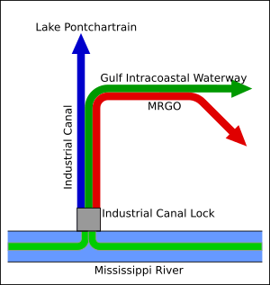
MRGO-- the Mississippi River Gulf Outlet-- does NOT connect Lake Pontchartrain and the Mississippi. It was completed in 1965 as a "short cut" for ocean-going vessels to access open waters of the Gulf.
What you are thinking of is the Inner Harbor Navigation Canal or IHNC, commonly called the Industrial Canal. Completed in 1923, it links the river to Lake Pontchartrain, but uses a set of locks to do so as the two waterways are at different elevations (river is higher; Lake Pontchartrain is essentially sea level). The Industrial Canal was built more for smaller cargo boats, barge traffic, etc. to allow access for boats bringing resources from "across the lake" or over in coastal Mississippi. It was never a "back door" for commercial ocean-going traffic.
The Industrial Canal was later incorporated into the Gulf Intracoastal Waterway (GIWW), a barge-oriented commercial waterway. When it was originally created in the 1930s, the GIWW had a route using the river, the IHNC, the Lake and the Rigolets to access Lake Borgne and the Mississippi Sound, but during World War II the GIWW was rerouted, with a newly excavated segment extending through the swamps west from the Rigolets joining the Industrial Canal at its approximate midway point between the river and the lake.
Schematic layout showing each:

Color representation. Blue line - 1923; green line - 1944; red line - 1965:
"Once they put the levees up in the 20th century, the delta was more controlled in the main channel and the sediment was more constantly suspended in faster current (and carried farther out)."
This wasn't a function of the levees, but a function of the jetties placed at the passes at the mouths of the river. In the late 1800s, silt sandbars often prevented ships from sailing in and out of the Mississippi River basin. Engineer James Eads postulated that jetties could solve the problem. Eads made a deal with Congress: he would build the jetties at his own expense, and if they maintained a 30-foot channel, Congress would then pay for the jetties.
In 1875, Eads built two parallel piers far out into the Gulf at the river's South Pass, which he predicted would narrow the river and increase its current. The concentrated current would then cut its own channel through the sandbar.
Eads’s jetties were completed in 1879 and maintained a 30-foot channel, eliminating the silt buildup, and opening up the mouth of the Mississippi once again to ships. New Orleans went from ninth largest port in the US to the second largest, just behind New York.
This post was edited on 8/9/23 at 11:20 am
Posted on 8/1/23 at 3:54 pm to NineLineBind
quote:
What am I missing? You just named cities on the right (east) side of the river.
Left bank/right bank of a river are referenced to the flow direction. So, looking downstream of the MS at Baton Rouge, the left bank is the east side.
Posted on 8/1/23 at 3:55 pm to Y.A. Tittle
This. Plantation owners lived on the higher ground and had their farms in the lower lands across the river. Malaria was a major threat back then and lower marshlands were prime habitat.

Posted on 8/1/23 at 4:25 pm to AggieHank86
quote:
("east" if some insist
I do insist because left isn’t always left depending on which direction you’re traveling.
East is always east
Posted on 8/1/23 at 4:33 pm to Jack Daniel
quote:And "Left Bank" is always the bank on your left when you are looking downstream.
I do insist because left isn’t always left depending on which direction you’re traveling.
East is always east
"Right Bank" is analogous to saying "starboard," and "Left Bank" is analogous to saying "port." ("BUT DAMMIT, the PORT is w'er' I park mah BOAT! It don' got nuthin tuh dew with the left side o' the damn thing!")
You refuse to believe me on a matter this simple and this clear. That is fine. Believe the three OTHER posters who have explained the same thing. Believe the links that have been posted.
The "Egyptian Mau" is a breed of cat. The fact that you are unfamiliar with the breed does not make this any less true.
This post was edited on 8/1/23 at 4:40 pm

Posted on 8/1/23 at 4:40 pm to BRich
quote:
Goofball's answer was close, but not entirely correct.
"making it necessary to use the Pontchartrain for ocean access. Is that correct?"
Nope. As Goofball pointed out, merchant ships at the time were much smaller. But Lake Pontchartrain is a really a shallow pond (average depth of 10-12') and as such was rarely used for ocean-going sailing vessels.
"they even built a link between the two in the form of MRGO, which actually caused massive flooding to New Orleans and Chalmette during Katrina"
In the 18th century, when the city was founded (and for a number of years thereafter), merchant sailing vessels were coming into Lake Pontchartrain and up into Bayou St. John.
Posted on 8/1/23 at 4:49 pm to Y.A. Tittle
Based upon the buildings, the clothing and the type of boat, I would say that this is mid-19th century.
interesting. thank you.

 Page 4 of 5

Back to top