- My Forums
- Tiger Rant
- LSU Recruiting
- SEC Rant
- Saints Talk
- Pelicans Talk
- More Sports Board
- Fantasy Sports
- Golf Board
- Soccer Board
- O-T Lounge
- Tech Board
- Home/Garden Board
- Outdoor Board
- Health/Fitness Board
- Movie/TV Board
- Book Board
- Music Board
- Political Talk
- Money Talk
- Fark Board
- Gaming Board
- Travel Board
- Food/Drink Board
- Ticket Exchange
- TD Help Board
Customize My Forums- View All Forums
- Show Left Links
- Topic Sort Options
- Trending Topics
- Recent Topics
- Active Topics
Started By
Message

 0
0

Posted on 9/26/22 at 5:08 am to FLObserver
They just put a flood warning for the Peace River at Punta Gorda. This storm surge is going to suck, from Bonita Springs, up.

Posted on 9/26/22 at 5:36 am to Hangit


This post was edited on 9/26/22 at 5:38 am
Posted on 9/26/22 at 5:37 am to Roll Tide Ravens
Even if Ian ultimately makes landfall closer to the big bend, much of the west coast of the Florida peninsula will be in for some pretty rough weather as Ian scrapes along the coast with its outer bands.
This post was edited on 9/26/22 at 5:38 am

Posted on 9/26/22 at 5:41 am to Roll Tide Ravens

Posted on 9/26/22 at 5:41 am to Roll Tide Ravens
Having been through a direct hit from Ida last year it gives me the chills to see this track. If you are near the coast get out. My neighbor stayed and said never again. If you catch the eastern eyewall nothing good can come of it. I pray it weakens as it approaches.
This post was edited on 9/26/22 at 5:42 am

Posted on 9/26/22 at 5:44 am to iron banks
quote:
I pray it weakens as it approaches.
Same, but also pointing all fans to the west
Posted on 9/26/22 at 5:45 am to Slagathor
This storm is getting really close to being an a-hole clencher

Posted on 9/26/22 at 5:45 am to Dexterous404
quote:
Dexterous404
Iam near you and new to the area. I live on 70 near Lakewood Ranch in west Bradenton. I guess we are going to get to learn with a terrible storm.
Lots to do today...
Posted on 9/26/22 at 5:46 am to Bobby OG Johnson
quote:
NWS OPC
@NWSOPC
·
1h
#HurricaneIan at 0500 AM EDT/0900 UTC
--------------------------------------------------
Location - 18.2N 82.0W
Max Sustained Winds - 65 KT (75 MPH)
Movement - NW AT 12 KT (14 MPH)
Min Central Pressure - 983 MB
Posted on 9/26/22 at 5:48 am to joshnorris14
quote:
This storm is getting really close to being an a-hole clencher
In an abundance of caution, I’ve been clenched since Saturday.
Posted on 9/26/22 at 6:09 am to LanierSpots
If you are west of Bradenton I would seriously consider evacuation options. Don’t wait until you can’t get out. Always leave 24 hours earlier than what you are currently thinking.
Posted on 9/26/22 at 6:11 am to Swazla
Storm rapidly intensified overnight. You need to evacuate

Posted on 9/26/22 at 6:11 am to rds dc
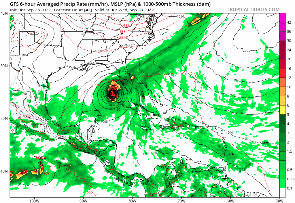
What struck me this morning was the agreement of the GFS and Euro models and the slow movement as Ian approaches the FL coast. Looks to be a Wed through Saturday event for the FL peninsula.
edit.. added img link to imgur (full size gif)

edit.. added img link to imgur (full size gif)
This post was edited on 9/26/22 at 6:35 am
Posted on 9/26/22 at 6:14 am to Bobby OG Johnson

This post was edited on 9/26/22 at 6:30 am

Posted on 9/26/22 at 6:15 am to rds dc
Is there a better radar to use in the OP? The storm is almost out of the picture.

Posted on 9/26/22 at 6:15 am to Swazla
quote:
seriously consider evacuation options
If anybody is leaving, avoid I-75. It turns into a parking lot for evac. events. People sat for so long that they ran out of gas, while sitting in traffic. Consider going west or southwest, away from the storm.
Posted on 9/26/22 at 6:24 am to Hangit
I’m in Ocala and have a sister-in-law flying home from Dallas to Tampa on Tuesday. I’m concerned about coming back to Ocala from the airport. A friend is supposed to pick her up but I’m pretty sure it’ll end up being me. No big concern in Ocala but losing power.
Posted on 9/26/22 at 6:33 am to Latebloomer
My friend lives right on the coast and she’s even freaking out.
Posted on 9/26/22 at 6:36 am to Swazla
. Ian will bring hurricane strength winds to The lower Georgia area too. Lots and lots of trees in that region

 Page 161 of 465

Popular
Back to top