- My Forums
- Tiger Rant
- LSU Recruiting
- SEC Rant
- Saints Talk
- Pelicans Talk
- More Sports Board
- Fantasy Sports
- Golf Board
- Soccer Board
- O-T Lounge
- Tech Board
- Home/Garden Board
- Outdoor Board
- Health/Fitness Board
- Movie/TV Board
- Book Board
- Music Board
- Political Talk
- Money Talk
- Fark Board
- Gaming Board
- Travel Board
- Food/Drink Board
- Ticket Exchange
- TD Help Board
Customize My Forums- View All Forums
- Show Left Links
- Topic Sort Options
- Trending Topics
- Recent Topics
- Active Topics
Started By
Message
re: Ancient Stone Carvings-Comet(s) Hitting Earth app.10,950 BC (p14, Shermer concedes...)
Posted on 2/19/18 at 8:06 am to DawgfaninCa

Posted on 2/19/18 at 8:06 am to DawgfaninCa
This is a great thread near and dear to my heart. A few points to add:
The evidence of an ancient forgotten civilization(s) that we’are currently unaware of is very compelling. From the origin stories shared all over the world to the recently found sites (gobekli tepe) predating the current timeline - it’s becoming clear that there was much more going on in ancient history than we know. I strongly recommend Fingerprints of the Gods and Underworld by Hancock - who can get a little woo woo in his other books but REALLY has some interesting points in these two.
Carlson’s work on ancient impacts is starting to catch on and is also very compelling. All you have to do is google Madagascar Chevron or Camas Prarie Flood and you’ll see that big things happened in the distant past. Also, the timing proposed aligns perfectly with the end of the ice age, beginning of modern civilization (ie everything “starts” at this period and ancient flood myths - including Atlantis. The JRP with Hancock and Carlson is an excellent place to go to hear all of this - but watch on YouTube so you can see the pictures.
These two separate theories come to gather to basically say that our ancient history was wiped clean around 12,000 years ago due to a series of impacts on the ice shelf - and that this may be a recurring event.
On a side note, the evidence that the ancients understood and marked the procession of the equinox - something that takes 26,000 years - is absolutely mind blowing.
This post was edited on 2/19/18 at 8:18 am
 2
2

Posted on 2/19/18 at 8:12 am to ThinePreparedAni
Hey thanks, ani

Posted on 2/19/18 at 8:25 am to SquatchDawg
quote:
All you have to do is google Madagascar Chevron or Camas Prarie Flood and you’ll see that big things happened in the distant past. Also, the timing proposed aligns perfectly with the end of the ice age, beginning of modern civilization (ie everything “starts” at this period and ancient flood myths - including Atlantis.
Yep. Images below are from the 1st page of thread. Posting again so they can be displayed
Chevron forms created on a stream sandbar by local spring floods in Georgia, USA. The significant point is that these forms were produced by flowing water, not wind. After the flood subsides and the sand deposits dry out they will become subject to wind erosion and modification until they are stabilized by vegetation.
Chevron forms found on the southern tip of Madagascar. Were these formations created by wind or water? If the chevrons are formed of fine-grained wind transported sediment why is the line of demarcation at the distal end so distinct? What kind of aeolian process would produce features of this form and magnitude? The light colored deposits near the upper end of the chevrons are sand. This sand is undoubtedly being modified by wind, but this does not mean that the whole complex of lancet-like forms composing the chevrons were originally created by wind.
For scale...

The Burckle Crater impact is speculated to be Noah's flood...
---

Small scale parabolic dune forms and hummocky topography produced by local flooding in Peachtree Creek, GA are clearly visible in this photograph. The open end of the parabola seen in the top center points in the up-current direction which was from right to left. Again, these sedimentary forms are initially produced by flowing water and later modified by wind.

Large scale parabolic dune forms on the Rolling Palouse landscape of SE Washington State. Note the large parabolic shaped dune in the foreground. It opens upcurrent, flow was from right to left (north to south). Compare the general morphology of this landscape with the water shaped forms in the previous photograph. This landscape is the product of wind AND water. A study of mega-scale paleohydrology reveals the scale-invariant, or self-similar nature of fluvial forms across a wide variety of spatial scales and signifies its value as a means of comparison and recognition of mega features whose origins it is not possible to witness directly.


Posted on 2/19/18 at 8:36 am to ThinePreparedAni
We peruse the same sites. 
I can’t believe any rational scientist would propose the Madagascar chevrons are wind generated when you look at that photo.
I can’t believe any rational scientist would propose the Madagascar chevrons are wind generated when you look at that photo.
Posted on 4/13/18 at 8:14 am to SquatchDawg
Nat Geo
The interplay of "settled science" , "religion" (I would argue that those are interchangeable terms...), mental inertia, etc...
Zoom out and view the discussion about "climate change" through this lens...
History can be very informative
We "know" very little...

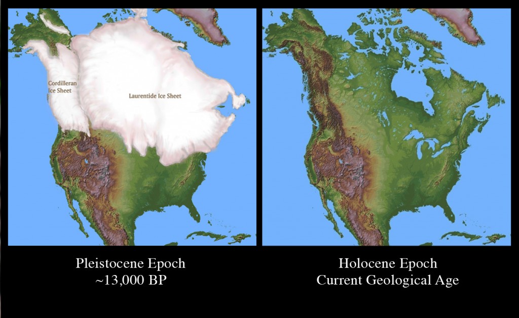
The folks linked at the beginning of this thread argue that the rapid melt was from a comet impact on the North American icecap...
Us and them
And after all we're only ordinary men
We live in a wild place
What we know is drop. What we don't know is an ocean (a violent one at that...). See sig quote below
quote:
Formed by Megafloods, This Place Fooled Scientists for Decades
Geologists couldn't account for the strange landforms of eastern Washington State. Then a high school teacher dared to question the scientific dogma of his day.
PUBLISHED MARCH 9, 2017
The interplay of "settled science" , "religion" (I would argue that those are interchangeable terms...), mental inertia, etc...
Zoom out and view the discussion about "climate change" through this lens...
History can be very informative
We "know" very little...
quote:
In the middle of eastern Washington, in a desert that gets less than eight inches of rain a year, stands what was once the largest waterfall in the world. It is three miles wide and 400 feet high—ten times the size of Niagara Falls—with plunge pools at its base suggesting the erosive power of an immense flow of water. Today there is not so much as a trickle running over the cataract’s lip. It is completely dry.
Dry Falls is not the only curiosity in what geologists call the Columbia Plateau. Spread over 16,000 square miles are hundreds of other dry waterfalls, canyons without rivers that might have carved them (called “coulees”), mounds of gravel as tall as skyscrapers, deep holes in the bedrock that would swallow entire city blocks, and countless oddly placed boulders. All across southeast Washington, fertile rolling hills border eroded tracts of volcanic basalt, as if Kansas farmland and Utah canyon land had been chopped up and sewed together into a topographic Frankenstein.
The first farmers in the region named the rocky parts “scablands” and dismissed them as useless as they planted their wheat on the silt-rich hills. But geologists were not so dismissive; to them, the scablands were an enigma. What could have caused this landscape? It was a question hotly debated for several decades, and the answer was as surprising and dramatic as Dry Falls itself.
quote:
And after two seasons in the field, his conclusions shocked even himself: The only possible explanation for the all the region’s features was a massive flood, perhaps the largest in the Earth’s history—“a debacle which swept the Columbia Plateau,” ripping soil and rock from the landscape, carving canyons and cataracts in a matter of days. “All other hypotheses meet fatal objections,” he wrote in a 1923 paper.
It was geological heresy. For almost a century, ever since Charles Lyell’s 1830 text Principles of Geology set the standards for the field, it had been assumed that geological change was gradual and uniform—always the product of, as Lyell put it, “causes now in operation.” And floods of quasi-Biblical proportions certainly did not meet that standard. It didn’t matter how meticulous Bretz’s research was, or how sound his reasoning might be; he seemed to be advocating a return to geology’s dark ages, when “scientists” used catastrophic explanations for the Earth’s features to buttress theological presumptions about the age of a Creator’s divine handiwork. It was unacceptable. How did canyons and cataracts form? By rivers, of course, over millions of years. Not gigantic floods. Period.
The folks linked at the beginning of this thread argue that the rapid melt was from a comet impact on the North American icecap...
quote:
Of course, for some of Bretz’s most stubborn critics, even eyewitness experience wasn’t enough. Bretz’s arch-adversary, Richard Foster Flint, a Yale geologist who remained a premier authority in the field until the 1970s, spent years studying the scablands and resisted Bretz’s theory until he was virtually the only one left who did. He finally acknowledged the scablands flooding (grudgingly, with a single sentence in a textbook in 1971), but as philosopher Thomas Kuhn observed, new scientific truths often win the day not so much because opponents change their minds, but because they die off. By the time the Geological Society of America finally recognized Bretz’s work with the Penrose Medal, the field’s highest honor, it was 1979 and Bretz was 96 years old. He joked to his son, “All my enemies are dead, so I have no one to gloat over.”
quote:
It is tempting to see this story as a simple morality tale, with “good guy” geologists lining up against “bad guy” geologists in a battle between open-minded inquiry and closed-minded dogmatism. But that might just compound the error, because it neglects the fact that scientists almost always favor their own theories over others’, and rarely are those theories completely right
Us and them
And after all we're only ordinary men
quote:
Perhaps it’s just as well that he didn’t. That sort of neat resolution might obscure what’s arguably the most important lesson of the scablands’ story—the caution that “nature has the answers, not us.” Just when we think we’ve got nature figured out, we find that among her many powers is the power to confound us, again and again and again.
We live in a wild place
What we know is drop. What we don't know is an ocean (a violent one at that...). See sig quote below

Posted on 4/13/18 at 8:20 am to ThinePreparedAni
GAP THEORY! FTW!
Posted on 4/13/18 at 8:28 am to ThinePreparedAni
quote:
according to astronomers, this giant comet probably arrived in the inner solar system some 20 to 30 thousand years ago, and it would have been a very visible and dominant feature of the night sky, it is hard to see how ancient people could have ignored this given the likely consequences
So this comet could have been around for 10000 to 20000 years before actually impacting, presumably with regular appearances, getting larger and larger with each return before finally impacting - no wonder the sky-watchers of the era made particular attention to it.
This stuff fascinates me - I just found out about Gobekli Tepi a couple of years ago - I hope the continue evaluating the site and making stuff like this public.
Posted on 4/13/18 at 8:32 am to ThinePreparedAni
How in the hell did they get comet storm from that?
I see three car doors, a few birds, and a mutant fish-frog thing.
Here's my translation:
In about 12,000 years, people will be able to sit comfortably in their SUVs to order delicious bird parts fried up nice and tender.
I see three car doors, a few birds, and a mutant fish-frog thing.
Here's my translation:
In about 12,000 years, people will be able to sit comfortably in their SUVs to order delicious bird parts fried up nice and tender.

Posted on 4/13/18 at 8:33 am to ChineseBandit58
quote:
This stuff fascinates me - I just found out about Gobekli Tepi a couple of years ago - I hope the continue evaluating the site and making stuff like this public.
Me too I've always been fascinated in this stuff and can't get enough. I heard about Gobekli Tepi on a Coast to Coast AM show a few years ago.

Posted on 4/13/18 at 8:39 am to kingbob
quote:
Early Bronze Age, between 1642 and 1540 BC. The natural disaster believed to line up with the story of Exodus is the Thera Supervolcano Eruption, modern day island of Santorini. This explosion wiped out, or severely weakened, the Minoan civilization and triggered tsunamis all around the Mediterranean. Thera is today believed by many scholars to be the legiondary island of Atlantis. Archeologists have found 5 story buildings with running hot and cold water preserved beneath the ash.
The idea is that a red tide on the Nile followed by the eruption of Thera would have produced all of the plagues and miracles (even the parting of the sea, columns of smoke/fire, etc) and it roughly fits the timeline of the reign of Pharoah Akhmoses, which means "Brother of Moses".
Watch the documentary patterns of evidence. It will blow your mind and absolutely proves (imo) the Exodus was way earlier.
Posted on 4/13/18 at 8:46 am to mtntiger
quote:
How in the hell did they get comet storm from that?
These "primitive" folks were able to make the site astronomically aligned (12K years ago...) while taking the procession of the equinox into account

This observation would take quite some time to have forehand knowledge of (as it is an approx 26K year cycle)...
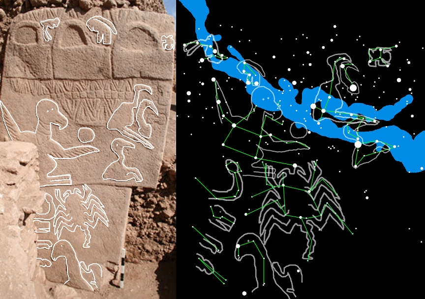
New Possible Astronomic Alignments at the Megalithic Site of Göbekli Tepe, Turkey
Alessandro De Lorenzis, Vincenzo Orofino*
Affiliation(s)
Dipartimento di Matematica e Fisica “E. De Giorgi”, Università del Salento, Lecce, Italy.
ABSTRACT
Gobekli Tepe is the oldest and one of the most important among the megalithic sites in the world. Its archaeoastronomical relevance has been recently evidenced by Collins (2013), according to whom the central pillars in four of the enclosures discovered in the site are oriented toward the setting point of the star Deneb (a Cyg), as this point moves in the course of the time, due to the equinox precession and the proper motion of the star. Taking into account these effects, Collins (2013) obtained an astronomical dating for the various enclosures which agrees rather well with the one obtained by Dietrich (2011) with the technique of carbon-14. In the present paper the careful evaluation of the effects caused by atmospheric extinction has enabled us to verify that the central pillars of the studied enclosures are in fact turned to face the setting point of Deneb, but these alignments occurred in epochs, still in agreement with the ones obtained by Dietrich (2011), but different from those proposed by Collins (2013). We have also individuated, for the first time, the probable astronomic alignments of two other enclosures at Gobekli Tepe, i.e. enclosures F and A. In particular, the first one seems to be oriented towards the rising point of the Sun on the day of the Harvest Festival, a day approximately halfway between the summer solstice and the autumn equinox. The second one, instead, shows an orientation towards the rising point of the Moon at its minor standstill. The positions of both celestial bodies have been obtained by extrapolating their declination to the date of the presumed construction reported by Dietrich (2011). A short discussion about the putative cultural motivations of these alignments is also presented.
This post was edited on 4/13/18 at 8:59 am
Posted on 4/13/18 at 12:28 pm to ChineseBandit58
quote:
quote:
I've never heard of that before now. Is it the PC way of saying BC?
Yeah - for about the last 20 years - at least that is when I first remember encountering it.
I first saw this in a Michener book (The Source, I think) some 40 or more years ago.

Posted on 4/13/18 at 12:49 pm to ThinePreparedAni
It's evolution and climate change science, in other words supposition. Nostradamus as a scientist if you will. Read the story. A comet strike is the leading hypothesis, and voila! A bunch of ambiguous carvings are interpreted to read exactly that! Science!
So let me get this straight. A comet cluster impacted the earth to the extent that it caused an ice age, but even roughly 11,000 years before Christ, there were enough inhabitants of the earth left with the technology, knowledge, knowhow, and desire, to create these carvings to document the event. Can I ask, what the hell did these people eat while they were carving these rocks, since there was essentially no sun?
So let me get this straight. A comet cluster impacted the earth to the extent that it caused an ice age, but even roughly 11,000 years before Christ, there were enough inhabitants of the earth left with the technology, knowledge, knowhow, and desire, to create these carvings to document the event. Can I ask, what the hell did these people eat while they were carving these rocks, since there was essentially no sun?
Posted on 4/13/18 at 1:08 pm to RollTide1987
quote:
Yeah...I don't understand why they do this BCE and CE bullshite. We all know what it means.
I always thought Before Christ's Era and Christ's Era was obvious. It's not that hard, fellas.
Posted on 4/18/18 at 3:34 pm to ChineseBandit58
quote:
prior comet/bollide impact
Youtube
quote:
New Graham Hancock the Evidence Mainstream Archaeology Does Not Want You to See
ZEG TV HIDDEN FROM THE PUBLIC 257,203 views SUBSCRIBE121K 3.4K213 Published on Mar 21, 2018
Graham Hancock explains how an entire episode of the human story has been lost, an advanced civilisation very different from our own, with advanced technologies In the teeth of opposition from orthodox historians, and an ideologically driven consensus, a new paradigm of prehistory is emerging that will change everything we have been taught to believe about ourselves. Technological skills that should have taken hundreds or even thousands of years to evolve were brought into use almost overnight-- and with no apparent antecedents whatever. Hancock shares his unique experiences and perspective on the mysteries of the human past and explains why he’s convinced we are a species with amnesia forced, more than 12,000 years ago. What is prehistory, after all, if not a time forgotten--a time for which we have no records?
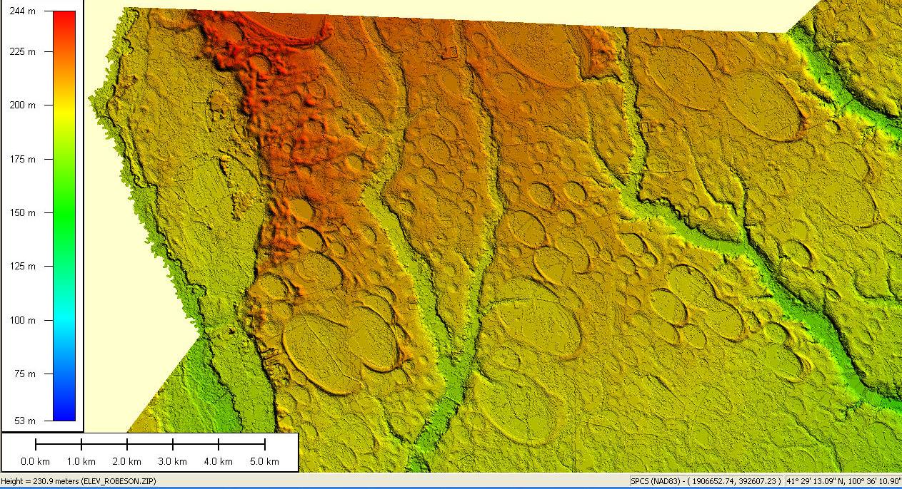
Hancock argues that the Carolina Bays (see below) were from fragments of ice (from the icecap) that were thrown into the upper atmosphere and landed /strewn about the areas surrounding North America...
At 45min in:
quote:
Carolina bays are elliptical depressions concentrated along the Atlantic seaboard within coastal Delaware, Maryland, New Jersey, North Carolina, South Carolina, Virginia, Georgia, and northcentral Florida.[1][2] In Maryland, they are called Maryland Basins (Rasmussen and Slaughter 1955). Within the Delmarva Peninsula, they and other coastal ponds are also called Delmarva bays.[3] Other landform depressions, not widely accepted as Carolina bays, are found within the northern Gulf of Mexico coastal plain in southeast Mississippi and Alabama, where they are known as either Grady ponds or Citronelle ponds.[4][5] Carolina bays vary in size from one to several thousand acres. About 500,000 of them are present in the classic area of the Atlantic Coastal Plain, often in groups, with each bay invariably aligned in a northwest-southeast direction. The bays have many different vegetative structures, based on the depression depth, size, hydrology, and subsurface. Many are marshy; a few of the larger ones are (or were before drainage) lakes; 36 square km (14 square mile) Lake Waccamaw is an undrained one. Some bays are predominantly open water with large scattered pond cypress, while others are composed of thick, shrubby areas (pocosins), with vegetation growing on floating peat mats. Generally the southeastern end has a higher rim composed of white sand. They are named for the bay trees frequently found in them, not because of the frequent ponding of water.[6] LIDAR elevation image of 300 square miles (800 km2) of Carolina bays in Robeson County, N.C. Undrained, often circular to oval, depressions exhibiting a wide range of area and depth are also a very common feature of the Gulf of Mexico coastal plain within Texas and southwest Louisiana. These depressions vary in size from 0.4 to 3.6 km (0.25 to 2 miles) in diameter. Within Harris County, Texas, raised rims, which are about 0.65 m (2 ft) high, partially enclosed these depressions. In the scientific literature, they are known by a variety of names, including pocks, pock marks, bagols, lacs ronds, and natural ponds.[7][8]
Posted on 4/18/18 at 5:51 pm to theunknownknight
I'm going to use my challenge:
How do you get from heating water, "hot running water", to the claims of high technology that was wiped out without a trace?
Where's your computer and wheeled go-cart powered by the sun?
Atlantis?
How do you get from heating water, "hot running water", to the claims of high technology that was wiped out without a trace?
Where's your computer and wheeled go-cart powered by the sun?
Atlantis?
This post was edited on 4/18/18 at 5:53 pm
Posted on 11/4/18 at 8:38 am to ThinePreparedAni
quote:
Atlantis?
https://m.youtube.com/watch?v=oDoM4BmoDQM&feature=youtu.be
quote:
The Lost City of Atlantis - Hidden in Plain Sight - Advanced Ancient Human Civilization
Bright Insight2,991,104 views
Published on Sep 4, 2018
Not only did the lost city of Atlantis actually exist, but its true location has been hiding in plain sight for thousands of years, completely unnoticed, as we’ve been looking in all the wrong places...Since everyone assumes that it must be under the ocean somewhere, such as in the depths of the Atlantic Ocean or the Mediterranean Sea, which have long been considered to be the most likely places for its existence. And no, I am not about to suggest that Antarctica is the hidden location of Atlantis, either. Because in this video, I am going to connect the dots on the exact words that Plato used to describe Atlantis, its location, and the geographical land features that surround it, which were recorded in Plato’s dialogues, the Critias and Timaeus. And the details that Plato shared of Atlantis, which I’m about to share with you in side by side comparison, will show you that the Richat Structure located in Mauritania Africa, also commonly referred to as the Eye of the Sahara, or the Eye of Africa…is the most likely location for the lost city of Atlantis.
YouTube - 2nd vid
YouTube- 3rd vid

https://www.nasa.gov/multimedia/imagegallery/image_feature_528.html

quote:
According to Plato, the Atlantean Empire was comprised of 10 kingdoms and its Island capital city, and was arranged in concentric, alternating rings of land and water; two of land and three of water, encircling one another; and a channel opening toward the south that led toward the sea. The size and dimensions of this description are remarkablely similar to the Richat formation. The diameter of the city’s outer ring measured 127 stadia, in today’s terms 23.49 km and the diameter of the outer circle of the Richat formation measures 23.50 km. There was said to be a spring of fresh water in the city’s center and a spring has also been located at the center of the Richat rings. The anomaly is also located southwest of the Pillars of Hercules (Straits of Gibraltar) mentioned in Plato’s description, below the Atlas mountain range in a vast central oblong shaped plane to the south.

Flood map:


https://www.theguardian.com/science/2015/nov/10/ancient-river-network-discoverd-buried-under-saharan-sand
quote:
Ancient river network discovered buried under Saharan sand
Radar images of the Mauritanian desert have revealed a river stretching for more than 500km and suggest plants and wildlife once thrived there
Ian Sample Science editor @iansample Tue 10 Nov 2015 12.09 EST Last modified on Wed 14 Feb 2018 12.28 EST
quote:
The French-led team behind the discovery believe the river carried water to the sea during the periodic humid spells that took hold in the region over the past 245,000 years. Water may last have coursed through the channels 5,000 years ago. The river would have helped people, plants and wildlife to thrive in what is now desert land, and would have carried nutrients crucial for marine organisms far into the sea. Were it still flowing today, the river system would rank 12th among the largest on Earth, the researchers write in the journal Nature Communications. Images taken from the satellite revealed that the hidden river beds aligned almost perfectly with a huge underwater canyon that extends off the coast of Mauritania into waters more than three kilometres deep. First mapped in 2003, the Cap Timiris Canyon is 2.5km wide and a kilometre deep in places.
quote:
It’s a great geological detective story and it confirms more directly what we had expected. This is more compelling evidence that in the past there was a very big river system feeding into this canyon,” said Wynn, who was not involved in the latest study. “It tells us that as recently as five to six thousand years ago, the Sahara desert was a very vibrant, active river system.”
quote:
“People sometimes can’t get their head around climate change and how quickly it happens. Here’s an example where within just a couple of thousand years, the Sahara went from being wet and humid, with lots of sediment being transported into the canyon, to something that’s arid and dry,” Wynn said.
Change in the blink of an eye...
This post was edited on 11/4/18 at 10:43 am

Posted on 11/4/18 at 8:42 am to ThinePreparedAni
This is some impressive thread necromancy.
Posted on 11/4/18 at 8:56 am to Joshjrn
1911...
https://www.nytimes.com/1911/01/30/archives/german-discovers-atlantis-in-africa-leo-frobenius-says-find-of.html
https://www.jasoncolavito.com/atlantis-in-africa.html
https://www.nytimes.com/1911/01/30/archives/german-discovers-atlantis-in-africa-leo-frobenius-says-find-of.html
quote:
GERMAN DISCOVERS ATLANTIS IN AFRICA; Leo Frobenius Says Find of Bronze Poseidon Fixes Lost Continent's Place.
Special Cable to THE NEW YORK TIMES.JAN. 30, 1911
https://www.jasoncolavito.com/atlantis-in-africa.html
quote:
BERLIN, Jan. 29. -- Leo Frobenius, author, leader of the German Inner-African exploring expedition, sends word from the hinterland of Togo, according to information reaching THE NEW YORK TIMES correspondent, that he has discovered indisputable proofs of the existence of Plato's legendary continent of Atlantis.
He places Atlantis, which he declares was not an island, in the northwestern section of Africa, in territory lying close to the equator.
The explorer bases his assertions principally on the discovery of an ancient bronze, the head of a man. It is a work of high artistic merit, he says, and dates back to the period ages before the day of Solon, when tradition peopled the legendary continent with a mighty nation which only the Athenians could conquer.
The bronze bears the insignia of Poseidon, the Greek equivalent of Neptune, and this fact is thought by the discoverer to bear out the tradition of an invasion of Atlantis by Athenians. Besides this Poseidon was by legend connected with the founding of the state.
Posted on 11/4/18 at 11:20 am to scrooster
quote:
It always made sense to me because human civilization was way behind in North America compared to other continents. I always figured it had to be because of a comet impact or the Yellowstone caldera.
There wasn't much civilization anywhere on Earth 13,000 years ago. While people back then were fully modern morphologically, their populations were extremely small. Too small to achieve any sort of "civilization" like we might think of in antiquity (Egypt, Greece, Rome, Indus Valley, etc.).
13,000 years ago was well before even the Neolithic. Therefore, people were nothing but bands of hunter-gatherers. This was true no matter the location or geography. Stones, spears, and bows and arrows were the tools in use. Metallurgy had not been discovered and horseback riding had not been invented yet either. So not only were populations small, but travel was slow. Life expectancy sucked too. If you were 40, you were a tribal elder.
People hunted mostly large game. They followed mammoth through Europe. Same thing in Asia. America was only being settled right at about 13,000 years ago - the time in question here. So perhaps some calamity precipitated the Indians leaving Asia. Of course, you could walk to America back then due to the ice. The question is did the Indians merely follow game here (as has long been the theory) or did they move in for some other reason.
Göbekli Tepe is the only example of a pre-neolithic stone structure of any significance. None others have been found despite archaeologists looking for them for a couple hundred years now. Of course, I wouldn't be surprised if there were others, but there certainly was no large civilization. The populations were simply too small and too immobile. We're talking tribes of maybe 20, 50, or 100 people traveling around hunting. Due to the small size of tribes, they weren't capable of much civilization, nor did they need it.
Civilization as we know it is the result of leisure time. Without leisure time, not much gets invented. It is widely believed that farming (invented about 10,000 years ago) gave people a steady food supply with reduced labor, thereby allowing people to invent new shite. As they became more sedentary, they had more kids, populations exploded, and civilization as we know it became a necessity.
So, even though ancient man was just as smart as us, that makes no difference. They were starting from scratch and had no point of reference for "civilization." Combine that with a very small population and not much gets done. You have to expend all your energy every day just staying alive. Hunting mammoth was hard and dangerous work and it took all a man's time. There was no good way to store meat, so you pretty much hunted, ate your kill, then started again.
By the way, Gobleki Teppe is in Turkey. I don't think that's a coincidence. Turkey is the heart of where farming is believed to have been invented (there and at the Tigris and Euphrates rivers). Perhaps the people there already had a farming system in place which gave them the leisure time needed to build a structure such as that. Perhaps they were a couple thousand years earlier with farming than previously thought. Of course, there is no evidence of farming anywhere nearby, which is a mystery.

 Page 8 of 15

Popular
Back to top