- My Forums
- Tiger Rant
- LSU Recruiting
- SEC Rant
- Saints Talk
- Pelicans Talk
- More Sports Board
- Coaching Changes
- Fantasy Sports
- Golf Board
- Soccer Board
- O-T Lounge
- Tech Board
- Home/Garden Board
- Outdoor Board
- Health/Fitness Board
- Movie/TV Board
- Book Board
- Music Board
- Political Talk
- Money Talk
- Fark Board
- Gaming Board
- Travel Board
- Food/Drink Board
- Ticket Exchange
- TD Help Board
Customize My Forums- View All Forums
- Show Left Links
- Topic Sort Options
- Trending Topics
- Recent Topics
- Active Topics
Started By
Message


 0
0

Posted on 10/21/20 at 4:43 pm to Cosmo
quote:
Epsilon spun up into a cute little hurricane
Major hurricane now. Kinda weird to see, just hanging out in the middle of a big upper level trough.
ETA: it's over pretty cool water to get to major status, despite it being warmer than normal out there. It has some outflow help and it being under the trough means the upper troposphere is cooler than typical over the tropics. So it still has a decent temperature differential to work with despite the cooler surface water.
Pretty sure this is the farthest north and east major on record for October and a strange storm for sure. Glad it's mostly a fish storm so I can just enjoy watching it.
This post was edited on 10/21/20 at 4:50 pm

Posted on 10/21/20 at 5:27 pm to Duke
quote:
Glad it's mostly a fish storm so I can just enjoy watching it.
My friend just sent me this off the road in Bermuda
/cdn.vox-cdn.com/uploads/chorus_image/image/56419255/DIS4F4JWsAA14QI.0.jpg)
Posted on 10/21/20 at 5:28 pm to LaBR4
I think that picture is fake
Posted on 10/21/20 at 5:32 pm to Walt OReilly
Not fake, can confirm

Posted on 10/21/20 at 5:46 pm to LaBR4
Damn. Should send that pic to weather channel, pretty cool
Posted on 10/21/20 at 6:06 pm to Duke
quote:
Major hurricane now. Kinda weird to see, just hanging out in the middle of a big upper level trough.
Philippe has a good breakdown of the setup. I just ate and I'm too lazy to find it right now.

Posted on 10/21/20 at 8:04 pm to LegendInMyMind
quote:
Replying to @FlynonymousWX
Best eye of the 2020 season #HurricaneEpsilon


Posted on 10/21/20 at 8:19 pm to Bobby OG Johnson
quote:
Best eye of the 2020 season
It is definitely the most picturesque.

Posted on 10/21/20 at 8:26 pm to Bobby OG Johnson
@pppapin

Pretty cool watching it fight off that dry air.
quote:
Watching the last 72h water vapor animation of #Epsilon from genesis to major hurricane is mesmerizing.
Starting on 00z 20 Oct, deep convection focused near the center & helped build an anticyclonic cocoon of moisture; shielding it from very dry air rotating around cyclonically. LINK
Pretty cool watching it fight off that dry air.
Posted on 10/21/20 at 8:36 pm to rds dc
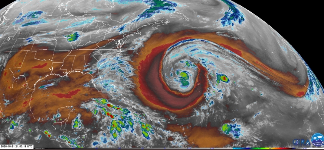
Look at that giant trough and the major hurricane just chilling in the middle.

Posted on 10/21/20 at 8:58 pm to LegendInMyMind
Epsilon says "what dry air?"
Posted on 10/21/20 at 9:10 pm to Duke
Great shot right here. That's a whole lot of real estate.
Posted on 10/21/20 at 10:35 pm to LegendInMyMind
Holy hell. Has like half the basin covered.
Looks like a comma shaped baroclinic cyclone look. Just with a hurricane in the middle and a puny looking cold front.
Looks like a comma shaped baroclinic cyclone look. Just with a hurricane in the middle and a puny looking cold front.
Posted on 10/22/20 at 12:15 am to Bobby OG Johnson
Damn that looks awesome
Posted on 10/23/20 at 6:44 am to deuce985
Tropical Weather Outlook
NWS National Hurricane Center Miami FL
800 AM EDT Fri Oct 23 2020
For the North Atlantic...Caribbean Sea and the Gulf of Mexico:
The National Hurricane Center is issuing advisories on Hurricane
Epsilon, located over the west-central Atlantic a couple of hundred
miles northeast of Bermuda.
1. A broad area of low pressure located near Grand Cayman Island is
producing a large area of showers and thunderstorms mainly east and
south of the center. This system has become much better organized
since yesterday, and a tropical depression could form during the
next couple of days while the low moves slowly toward the northwest.
This system is now anticipated to move near western Cuba this
weekend and move slowly across the southeastern Gulf of Mexico by
early next week. Regardless of development, locally heavy rainfall
will be possible over portions of the Cayman Islands, Cuba,
southern Florida and the Keys, and the northwestern Bahamas through
the weekend.
* Formation chance through 48 hours...medium...50 percent.
* Formation chance through 5 days...medium...60 percent.
Forecaster Blake/Papin
It was initally suppose to go northeast away from the US now it likes nope gonna head into the Gulf now.

Posted on 10/23/20 at 7:03 am to lsuman25
What in the chicken fried frick is that in orange?
STOP, BY GAWD!
STOP, BY GAWD!

Posted on 10/23/20 at 7:05 am to lsuman25

Posted on 10/23/20 at 8:39 am to Roll Tide Ravens
Philippe Papin joins NHC and his first report is this shite 

 Page 15 of 228

Popular
Back to top