- My Forums
- Tiger Rant
- LSU Recruiting
- SEC Rant
- Saints Talk
- Pelicans Talk
- More Sports Board
- Fantasy Sports
- Golf Board
- Soccer Board
- O-T Lounge
- Tech Board
- Home/Garden Board
- Outdoor Board
- Health/Fitness Board
- Movie/TV Board
- Book Board
- Music Board
- Political Talk
- Money Talk
- Fark Board
- Gaming Board
- Travel Board
- Food/Drink Board
- Ticket Exchange
- TD Help Board
Customize My Forums- View All Forums
- Show Left Links
- Topic Sort Options
- Trending Topics
- Recent Topics
- Active Topics
Started By
Message
re: Weather technology is becoming too good
Posted on 4/19/19 at 5:19 pm to doubleb
Posted on 4/19/19 at 5:19 pm to doubleb
Most updated stuff I found, though I didn't look super hard.
There's just better modeling now, with more computing power. This is improving the accuracy for the same reason you can see such a jump over all time frames from the 1990s on.
Just look at yesterday.


There's just better modeling now, with more computing power. This is improving the accuracy for the same reason you can see such a jump over all time frames from the 1990s on.
Just look at yesterday.
 1
1

Posted on 4/19/19 at 9:49 pm to Duke
The problem was much of that red area didn’t have much riugh weather. Sure they called for tornadoes but the area was so large that they couldn’t really miss.
Just saying that south of the Miss. La. border is a different call than north and west of that.
Just saying that south of the Miss. La. border is a different call than north and west of that.
Posted on 4/19/19 at 9:57 pm to Green Chili Tiger
quote:
So you're saying they were accurately wrong?
I think you missed the point.
And I think his take is accurate.
In summary, I think what he is saying is that with today's weather technology they are able to see the potential weather patterns have, but things change on a dime so you can't blame the weather people for that.
Weather is somewhat like betting on sports. You can look at all the data and all the numbers can favor one team, but that doesn't mean that team will always win.
Posted on 4/19/19 at 10:05 pm to doubleb
quote:
You have a link to quantify just how much better the 24 hour forecast has gotten over the last decade?
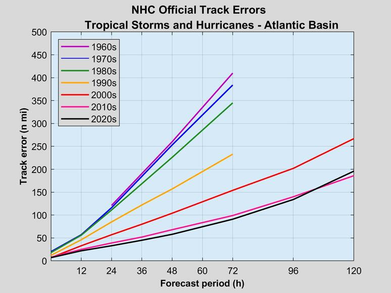
It's not perfect since it's only tropical systems, but if still illustrates the point. Average track error is about 33% more accurate this decade than it was in the previous decade, and so on and so forth.
I'd you think predicting hurricanes 24 hours out is easy, this still shows the relative improvements that have been made.
Posted on 4/19/19 at 10:08 pm to slackster
It’s well documented that tropical storm forecasts have improved a lot as far as determining a storm’s direction; however, intensity forecasts have not.
Forecasting weather 24 hours out, has it improved over the last decade?
Forecasting weather 24 hours out, has it improved over the last decade?
Posted on 4/19/19 at 10:08 pm to doubleb
quote:
The problem was much of that red area didn’t have much riugh weather. Sure they called for tornadoes but the area was so large that they couldn’t really miss.
The area was 30%. If you took that as a guarantee, I don't know what to tell you.

If you think this is a miss, I don't know what to tell you.
Posted on 4/19/19 at 10:12 pm to doubleb
quote:
It’s well documented that tropical storm forecasts have improved a lot as far as determining a storm’s direction; however, intensity forecasts have not.
How do you think they've got better at this but not any better at the overall weather?
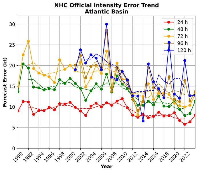
Fwiw, they've improved, albeit slightly, with intensity over time too.
Posted on 4/19/19 at 10:17 pm to doubleb
quote:
The problem was much of that red area didn’t have much riugh weather.
There's wind reports all up in the red section. It did end up being too far south based on the # of reports, but covered Alabama and Mississippi wind extent pretty well. The reason was all the storms that fired up at the same time ahead of the line where the best energy was. That wasn't happening in Mississippi and Alabama. The risk was the same, it just materialized north of here.
quote:
Sure they called for tornadoes but the area was so large that they couldn’t really miss.
Much smaller chunk of the overall "enhanced" risk zone, and also where all the tornadoes were. Models had great tornado profiles from South Louisiana up to Birmingham. Yet they put the highest risk zone over where the tornadoes actually happened. Why? Modern CAMs depicted the area for most of the rotating updrafts as the system developed.
It takes our ever improving models and incredible expertise to get this right.
Posted on 4/19/19 at 10:23 pm to slackster
It was not nearly as severe in south La. as it was in the more traditional tornado alley, yet the colored area is the same. That’s all I’m saying.
They missed in s La.
They missed in s La.
Posted on 4/19/19 at 10:24 pm to Duke
That’s how I saw it too
Posted on 4/19/19 at 10:26 pm to doubleb
quote:
It was not nearly as severe in south La. as it was in the more traditional tornado alley, yet the colored area is the same. That’s all I’m saying.
They missed in s La.
They didn't color southern LA with anything more than a 5% tornado chance. What did you expect to happen?
ETA - eve if we're talking about the wind only, it's still a probability thing. They didn't say you were absolutely going to see severe winds, so how did they miss?
This post was edited on 4/19/19 at 10:28 pm
Posted on 4/19/19 at 10:27 pm to slackster
Look at the map
S la, was given the same chances as was C Miss.
S la, was given the same chances as was C Miss.
Posted on 4/19/19 at 10:30 pm to doubleb
quote:
Look at the map
S la, was given the same chances as was C Miss.
For wind, not tornades.
These threads do point out a real problem with the NWS - the average person still doesn't understand them.
This post was edited on 4/19/19 at 10:35 pm
Posted on 4/19/19 at 10:36 pm to slackster
quote:
These threads do point out a real problem with the NWS - the average person still doesn't understand them.
There's a reason there are TV Mets and media to explain this stuff to people. People aren't great at probabilities. Just saying the SPC products are meant for a different audience than just general public consumption.
This post was edited on 4/19/19 at 10:37 pm
Posted on 4/19/19 at 10:36 pm to slackster
quote:
These threads do point out a real problem with the NWS - the average person still doesn't understand them.
I’m an average person, I see the forecast. It called for an enhanced chance of severe weather from the GOM and well north.
They close schools and close govt.
Now it’s over and you guys saying that the experts knew it would be worse in central Miss, and not as bad in S La.?
Then why was the map colored the same?
It doesn’t add up to a regular person
Posted on 4/19/19 at 10:56 pm to doubleb
quote:
I’m an average person, I see the forecast. It called for an enhanced chance of severe weather from the GOM and well north.
This is fair.
If you read the details, you'd see they thought we'd get too much early convection down here vs up north and that the best severe parameters would likely be in Mississippi. The problem is, the discussions are full of technical jargon and are meant for meteorologists far more than the lay person.
It's why I'm saying...
quote:
Now it’s over and you guys saying that the experts knew it would be worse in central Miss, and not as bad in S La.?
Because they said that because of something that would likely limit the tornado/higher end wind risk down here.
The graphic doesn't illustrate that well, I do understand your point there.
Posted on 4/20/19 at 1:02 am to Duke
Glad you see my point.
Btw, I read your threads religiously and try to learn.
Keep them up.
Btw, I read your threads religiously and try to learn.
Keep them up.
Posted on 4/20/19 at 7:07 am to doubleb
quote:
Now it’s over and you guys saying that the experts knew it would be worse in central Miss, and not as bad in S La.?
Then why was the map colored the same?
They're colored the same because severe weather is either hail, tornados, or 50kt winds. If one broad area has a 30% chance of severe winds, and within that area, there is a subset that has a 10% chance for a tornado, they're going to be the same color in the categorical breakdown.
Notice how the contours of the categorical outlook match the wind outlook.

However, the increased tornado threat was different, but not enough to step up from the enhanced to moderate category.
Ultimately, the chance for severe weather was the same throughout that categorical contour, but the type of severe weather threat differed.
Posted on 4/20/19 at 9:37 am to slackster
The chance was the same, but it wasn’t the same in real time.
Posted on 4/20/19 at 10:02 am to tgrbaitn08
quote:I'm with you. Society has gotten soft. People manned up and went to work 20 years ago in the conditions that we close everything in now. Watch this upcoming football season and you'll see what we mean
Why didn’t they close down the schools and government 25-30 years ago when I was in school everytime it rained?
Whats changed?

 Page 6 of 7

Popular
Back to top