- My Forums
- Tiger Rant
- LSU Recruiting
- SEC Rant
- Saints Talk
- Pelicans Talk
- More Sports Board
- Coaching Changes
- Fantasy Sports
- Golf Board
- Soccer Board
- O-T Lounge
- Tech Board
- Home/Garden Board
- Outdoor Board
- Health/Fitness Board
- Movie/TV Board
- Book Board
- Music Board
- Political Talk
- Money Talk
- Fark Board
- Gaming Board
- Travel Board
- Food/Drink Board
- Ticket Exchange
- TD Help Board
Customize My Forums- View All Forums
- Show Left Links
- Topic Sort Options
- Trending Topics
- Recent Topics
- Active Topics
Started By
Message
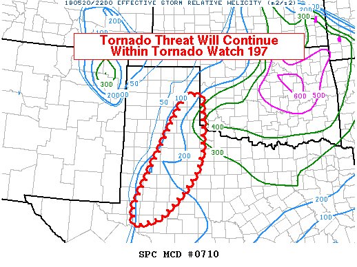
re: Weather for Monday, May 20. Attention: N TX, Cen. OK, S KS High risk forecast
Posted on 5/20/19 at 5:54 pm to StraightCashHomey21
Posted on 5/20/19 at 5:54 pm to StraightCashHomey21
It's 72 degrees in OKC, isn't that a litle cool for a stronger tornado?
 1
1


Posted on 5/20/19 at 5:55 pm to Scoop
The cell that has been putting down the pain is getting absorbed by the line.
Posted on 5/20/19 at 5:58 pm to Scoop
No one hurt in Mangum
Posted on 5/20/19 at 5:59 pm to StraightCashHomey21
Good news.
No one knows how to deal with that stuff better than those people.
No one knows how to deal with that stuff better than those people.
Posted on 5/20/19 at 6:00 pm to Scoop
That house and car in Perry got fricked up
Posted on 5/20/19 at 6:00 pm to Scoop
Posted on 5/20/19 at 6:05 pm to Roll Tide Ravens
quote:
While there are certainly some violent storms out there, I feel like this has sort of underperformed so far. Not that that is a bad thing. Certainly things could ramp up later, though.
One thing is for sure, the cap held stronger across a lot of the warm sector than some CAMs were showing last night and this morning. This has kept most of the convection focused along the warm front and down the dryline. We haven't seen wave after wave of discrete supercells streaming north out of Texas and into Ok across the wide open warm sector. That has certainly kept things well below top end potential for this event. There is still some time left for storms to fire in the warm sector but it mostly looks like convection will stay messy along the warm front and dryline and eventually line out.

Posted on 5/20/19 at 6:09 pm to rds dc

quote:
Ginger Zee
We are just crossing into Oklahoma — PDS TORNADO WATCH - particularly dangerous situation. Storms already firing in texas panhandle - let’s talk!

Posted on 5/20/19 at 6:18 pm to rds dc
quote:
One thing is for sure, the cap held stronger across a lot of the warm sector than some CAMs were showing last night and this morning. This has kept most of the convection focused along the warm front and down the dryline. We haven't seen wave after wave of discrete supercells streaming north out of Texas and into Ok across the wide open warm sector. That has certainly kept things well below top end potential for this event. There is still some time left for storms to fire in the warm sector but it mostly looks like convection will stay messy along the warm front and dryline and eventually line out.
Excellent analysis. If things don’t ramp up, particularly on east into Oklahoma, SPC is going to take a hit PR wise.
Posted on 5/20/19 at 6:28 pm to Roll Tide Ravens
There were some reports earlier of funnel clouds around Joplin, MO.
Posted on 5/20/19 at 6:30 pm to Roll Tide Ravens
Things seem to have calmed down around the state
We are still under PDS
We are still under PDS
This post was edited on 5/20/19 at 6:35 pm
Posted on 5/20/19 at 6:35 pm to LaBR4
Looks like Ginger has a tight grip around a wiener.
Posted on 5/20/19 at 6:38 pm to Roll Tide Ravens
Hasn’t been near as turbulent as I expected, overnight may be rather bumpy.
We opted for better safe than sorry and am confident criticisms will surface, which I understand
Don’t know about the PR angle but people may tend to be more dismissive in the future
We opted for better safe than sorry and am confident criticisms will surface, which I understand
Don’t know about the PR angle but people may tend to be more dismissive in the future
Posted on 5/20/19 at 6:41 pm to Roll Tide Ravens
quote:
If things don’t ramp up, particularly on east into Oklahoma, SPC is going to take a hit PR wise.
Especially when you consider this is only the second time SPC has placed values this severe on a potential outbreak - the other one, of course, being the Super Outbreak of 2011.
Posted on 5/20/19 at 6:42 pm to wfallstiger
Wouldn’t have believed it this morning if you had told me that at 6:45pm there would be no active tornado warnings in Oklahoma.
Posted on 5/20/19 at 6:51 pm to vuvuzela
72 is plenty warm for a tornado. What's more telling is the dew point if you are going by raw numbers. You generally want the DP to be in at least the mid 60's to feed the storms.
Posted on 5/20/19 at 6:53 pm to Crimson1st
1 tornado warning currently in Missouri... 2 in Texas
Posted on 5/20/19 at 6:55 pm to Roll Tide Ravens
Still have to ride out the night though
Heavy storms expected with in the next two hours and then through the night
Heavy storms expected with in the next two hours and then through the night
Posted on 5/20/19 at 6:57 pm to StraightCashHomey21
A line is a much better look for all interests vs the feared parade of individual cells. It's early still but glad it appears most everyone dodged the bullet today.

Posted on 5/20/19 at 7:02 pm to Duke
quote:
A line is a much better look for all interests vs the feared parade of individual cells. It's early still but glad it appears most everyone dodged the bullet today.
I feel better currently, but still cautious.
What are you guys thoughts on the Broken Arrow area? If you care to look to give an opinion. It looks as if the newly formed line of storms are moving our direction. I would expect some sort of wind event and still a threat of spin ups.

 Page 25 of 31

Popular
Back to top