- My Forums
- Tiger Rant
- LSU Score Board
- LSU Recruiting
- SEC Rant
- SEC Score Board
- Saints Talk
- Pelicans Talk
- More Sports Board
- Coaching Changes
- Fantasy Sports
- Golf Board
- Soccer Board
- O-T Lounge
- Tech Board
- Home/Garden Board
- Outdoor Board
- Health/Fitness Board
- Movie/TV Board
- Book Board
- Music Board
- Political Talk
- Money Talk
- Fark Board
- Gaming Board
- Travel Board
- Food/Drink Board
- Ticket Exchange
- TD Help Board
Customize My Forums- View All Forums
- Show Left Links
- Topic Sort Options
- Trending Topics
- Recent Topics
- Active Topics
Started By
Message

 3
3


Posted on 5/20/19 at 1:39 pm to Hawgeye
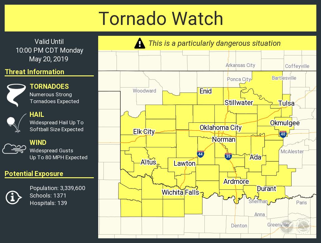
Actually, I missed that watch. Wagoner County not included, but still close enough.
Posted on 5/20/19 at 1:39 pm to StraightCashHomey21
Last time May 20 fell on a Monday an EF 5 hit Moore, OK. in 2013. I am currently in Moore, OK. Be safe everyone in the area.
Posted on 5/20/19 at 1:39 pm to Roll Tide Ravens
quote:
@NWSSPC
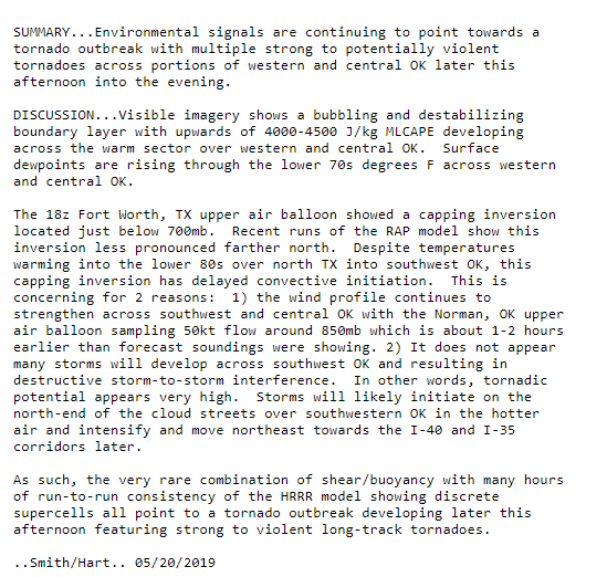
PDS Tornado Watch # 199 is coming for Oklahoma. This is only the second watch in SPC history where every category of watch probabilities (torn, wind, hail) are at greater than 95%. The only other watch like this was issued for Alabama on 27 April 2011.
You never want to share company with April 27.
Posted on 5/20/19 at 1:40 pm to ElOsoBlanco7
quote:
quote:
It was a 45% hatched on 4/27 too to highlight the potential today.
That day still sets itself apart from a forecasting perspective because of the >95% chance of all severe modes in one of the PDS watches. I'm curious if today will come close to that.
Welp...there goes that record.
Posted on 5/20/19 at 1:42 pm to rt3
quote:
...THIS IS A PARTICULARLY DANGEROUS SITUATION...
Well there it is - the infamous April 27 2011 numbers:
quote:
Tornadoes
Probability of 2 or more tornadoes
High (>95%)
Probability of 1 or more strong (EF2-EF5) tornadoes
High (>95%)
Wind
Probability of 10 or more severe wind events
High (>95%)
Probability of 1 or more wind events > 65 knots
High (>95%)
Hail
Probability of 10 or more severe hail events
High (>95%)
Probability of 1 or more hailstones > 2 inches
High (>95%)
Combined Severe Hail/Wind
Probability of 6 or more combined severe hail/wind events
High (>95%)

Posted on 5/20/19 at 1:42 pm to ElOsoBlanco7
What's best the live feed? Is the local KFOR going Live?
This post was edited on 5/20/19 at 1:42 pm
Posted on 5/20/19 at 1:42 pm to Lsuhoohoo
quote:
@NWSSPC
PDS Tornado Watch # 199 is coming for Oklahoma. This is only the second watch in SPC history where every category of watch probabilities (torn, wind, hail) are at greater than 95%. The only other watch like this was issued for Alabama on 27 April 2011.
Posted on 5/20/19 at 1:42 pm to Roll Tide Ravens
Wind has picked up here at the house. Seems like the wind has shifted a bit and is coming from the south east now.
Posted on 5/20/19 at 1:44 pm to LaBR4
quote:
What's best the live feed? Is the local KFOR going Live?
For OKC it may be their channel 9 news station. It is the sister station to News on 6 in Tulsa and both stations have helicopters they put in the air during storms that usually have great shots. They also have their own storm chasers on the ground.

Posted on 5/20/19 at 1:45 pm to Hawgeye
What is it about May 20th in Oklahoma?

Posted on 5/20/19 at 1:46 pm to Hawgeye
Man I miss Dr. Greg Forbes for events like this. I'll never forget when he said oh boy we have a debris ball when the tornado hit Tuscaloosa.
Posted on 5/20/19 at 1:47 pm to Hawgeye
I would imagine we're only a half hour or so from our first tornado warnings of the day. Those cells near Lubbock look worrisome.
Posted on 5/20/19 at 1:49 pm to slackster
Posted on 5/20/19 at 1:50 pm to lsuman25
quote:
Man I miss Dr. Greg Forbes for events like this. I'll never forget when he said oh boy we have a debris ball when the tornado hit Tuscaloosa.
James Spann was calling his own tornado emergencies that day... he wasn't waiting for the NWS to put them out

Posted on 5/20/19 at 1:50 pm to slackster
Yall be safe over there

Posted on 5/20/19 at 1:51 pm to slackster
I am really hoping these little showers that keep rolling over us help keep our temps down for a while and keep us covered in clouds. That is probably the only hope we have and that may not be very much hope at all.
Posted on 5/20/19 at 1:52 pm to Hawgeye
that storm east of Lubbock has exploded and is now severe thunderstorm warned.
Posted on 5/20/19 at 1:52 pm to Hawgeye
quote:
I am really hoping these little showers that keep rolling over us help keep our temps down for a while and keep us covered in clouds. That is probably the only hope we have and that may not be very much hope at all.
TWC saying it's not really mattering much today
Posted on 5/20/19 at 1:53 pm to rt3
quote:
TWC saying it's not really mattering much today
Yea I know...but for my sanity I am going to keep telling myself that. I think it may matter more for us being on the eastern side of the state, but could be wrong.

 Page 11 of 31

Popular
Back to top