- My Forums
- Tiger Rant
- LSU Recruiting
- SEC Rant
- Saints Talk
- Pelicans Talk
- More Sports Board
- Fantasy Sports
- Golf Board
- Soccer Board
- O-T Lounge
- Tech Board
- Home/Garden Board
- Outdoor Board
- Health/Fitness Board
- Movie/TV Board
- Book Board
- Music Board
- Political Talk
- Money Talk
- Fark Board
- Gaming Board
- Travel Board
- Food/Drink Board
- Ticket Exchange
- TD Help Board
Customize My Forums- View All Forums
- Show Left Links
- Topic Sort Options
- Trending Topics
- Recent Topics
- Active Topics
Started By
Message
re: UPDATE: Another Potential Severe Weather Event for the South (insert dates)
Posted on 3/26/21 at 10:31 am to rt3
Posted on 3/26/21 at 10:31 am to rt3
Video of Eutaw, AL tornado. That car in front of them.... 

If that had been a strong tornado when it crossed the road, they'd be in a mess!
YouTube video from chaser James Burch
If that had been a strong tornado when it crossed the road, they'd be in a mess!
YouTube video from chaser James Burch
 3
3


Posted on 3/26/21 at 10:41 am to LegendInMyMind
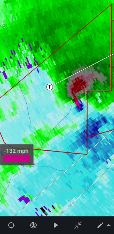
I was following a tornado on Radar Scope yesterday near Brent. One of the most impressive ones I've seen on radar in my 10 years of using Radarscope. We get any info how big the Brent tornado was?
Posted on 3/26/21 at 10:49 am to Roll Tide Ravens
I feel like the one they tracked from Calera to PC in ga is incomplete - i thought it had touched down west of Calera before reaching there.
Posted on 3/26/21 at 10:58 am to DeoreDX
quote:
We get any info how big the Brent tornado was?
It'll be a day or two for prelim assessments to start coming in. They are using helicopters to survey, and I'm sure they want to get on the ground, and probably already are in a lot of places, ASAP. They will do what they can around the clean-up and any search and rescue that is ongoing.
Posted on 3/26/21 at 11:01 am to Thracken13
quote:
I feel like the one they tracked from Calera to PC in ga is incomplete - i thought it had touched down west of Calera before reaching there.
We will see those tracks change. Almost certainly, they won't remain a steady track as if a tornado stayed on the ground and never lifted. We may even see tracks split a bit, or even one path become two distinct tornadoes. It happened with final surveys after April 27.

Posted on 3/26/21 at 11:02 am to LegendInMyMind
3 of the people who died in Ohatchee, AL were from the same family. They were in a wood framed home. Another man died there in a mobile home. A woman died in a mobile home just east of Ohatchee, in the community of Wellington.
This post was edited on 3/26/21 at 11:03 am
Posted on 3/26/21 at 11:05 am to LegendInMyMind
For those wondering about failure mode and lack of more northern development over MS/AL, here is as good a hypothesis that I have seen:
@tlyzawx
Now, I need to look up some acronyms.
@tlyzawx
quote:
Overall, I don't actually regret this. Early postmortem (pending survey results/verification):
-There was indeed a hell of an EML across MS. So much so, that it really largely inhibited convection from maturing until close to the AL border
quote:
-The EML never really made it into AL. The convection that was present there kept modifying it as it was advected in from the west. There was a very slight hint of it at BMX by 00Z, which was around when convective coverage was decreasing in AL as the shortwave began to lift out.
quote:
-One of the most significant players of the day was a major prefrontal trough in central MS. Behind this trough, hodographs absolutely collapsed, as evidenced by the JAN RAOBs and the DGX VWP hodographs.
quote:
-Rapid airmass recovery was observed to some degree, with major mass field improvement on the GWX VWPs in the early-mid afternoon. However, the amount of convection that had developed upstream in central AL just left north AL and NE MS a bit too stable.
quote:
-Despite the EML advection and the CAMs backing off, the amount of convection that resulted in central AL did end up being problematic toward a bigger event. Not so much b/c of interaction w/each other, but b/c of the downstream impact on the environment farther north.
quote:
-The extreme parameter space did verify, just over a much smaller area than what the vast majority of guidance indicated. This was a mesoscale modulation, the understanding of which is predicated largely by processes we still parameterize in models (microphysics).
Now, I need to look up some acronyms.
This post was edited on 3/26/21 at 11:06 am
Posted on 3/26/21 at 11:17 am to Nigel Farage
Texted my old boss to see if they got hit. He lives in Tyrone. Which for our LA baws is NE of Newnan. He said it just missed them.
Posted on 3/26/21 at 11:29 am to Roll Tide Ravens
The one storm on the ground from just west of Tuscaloosa near the MS line and went through Rome and ended in Cartersville(TLaw's hometown) for 225 miles. And the one that hit Newnan starting halfway between B'Ham and Montgomery for 125 miles!
Jesus Christ!
Jesus Christ!
This post was edited on 3/26/21 at 11:36 am
Posted on 3/26/21 at 11:42 am to SteelerBravesDawg
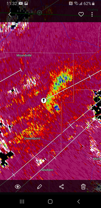
This is video of damage Northeast of Greensboro, AL where velocity looked the strongest on the tornado that ended up in Brent/Centreville.
@HarlessJim
This is a screenshot of the velocity radar image I took at that same spot/time:
This is the Tornado Debris Signature on CC I took at the same spot/time. There appears to be debris lofted and carried upstream from the tornado, similar to radar images from the Newnan tornado.
This would have been CC a bit earlier when the tornado was in the wooded area west of where the video was taken on 25.
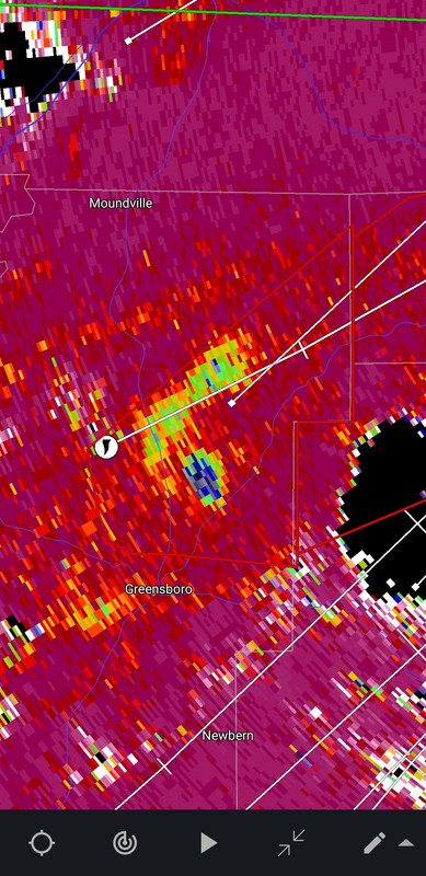
The larger debris signature would have been the heavy tree damage, and any structures in the path before that.
@HarlessJim
quote:
@spann this was about 10 miles north of Greensboro on highway 25. LINK
This is a screenshot of the velocity radar image I took at that same spot/time:
This is the Tornado Debris Signature on CC I took at the same spot/time. There appears to be debris lofted and carried upstream from the tornado, similar to radar images from the Newnan tornado.
This would have been CC a bit earlier when the tornado was in the wooded area west of where the video was taken on 25.
The larger debris signature would have been the heavy tree damage, and any structures in the path before that.
Posted on 3/26/21 at 11:42 am to SteelerBravesDawg
quote:
The one storm on the ground from just west of Tuscaloosa near the MS line and went through Rome and ended in Cartersville(TLaw's hometown) for 225 miles.
That was the first confirmed of the day. That thing just wouldn't die.

Posted on 3/26/21 at 11:45 am to LegendInMyMind
After watching the drone footage from Newnan. Good God, we dodged a bullet here when it lifted up somewhere over Thomas Crossroads west of us.
Posted on 3/26/21 at 12:04 pm to tgrbaitn08
So other than the multiple large and destructive tornados that killed several people, this event was a complete bust! It didn't even rain in my area! You weather thread dorks always rush to be the first to start these threads days in advance and then nothing happens.
Did I do it right?
quote:
tgrbaitn08
Did I do it right?
Posted on 3/26/21 at 1:45 pm to LegendInMyMind
quote:
Definitely alot of work to do on the "When and Where" aspect of this outbreak
This fail mechanism is what makes Dixie so tough to get the when and where right.
Looks to me the synoptics worked to fire storms early (not really sure what was causing the focus where it was though) and overspread that NE MS/NW AL zone with some stable air. Trapping a big hunk of the ridiculous parameters without a ton of instability. And then the surface low wasn't as powerful as advertised.
Left a boundary and the upper level support was still there south of Birmingham. Good set up for one narrow portion of the state to get round after round of long track tornadoes.
Posted on 3/26/21 at 1:48 pm to Lsuhoohoo
Enhanced risk tomorrow for North Ms, West TN, NE Arkansas


Posted on 3/26/21 at 2:18 pm to deltaland
Oh fricked. I’m doomed.
Posted on 3/26/21 at 2:41 pm to Rebel
quote:
NWS Birmingham
@NWSBirmingham
A quick update from our multiple survey teams out in the field today: at least EF-2 damage found in the Eagle Point area. At least EF-2 damage found in the Ohatchee area. We will continue to provide updates as our survey teams evaluate additional damage locations. #alwx
This is the tornado that went through the southern suburbs of the B’ham Metro and then continued northeastward impacting places east of Birmingham like Ohatchee.
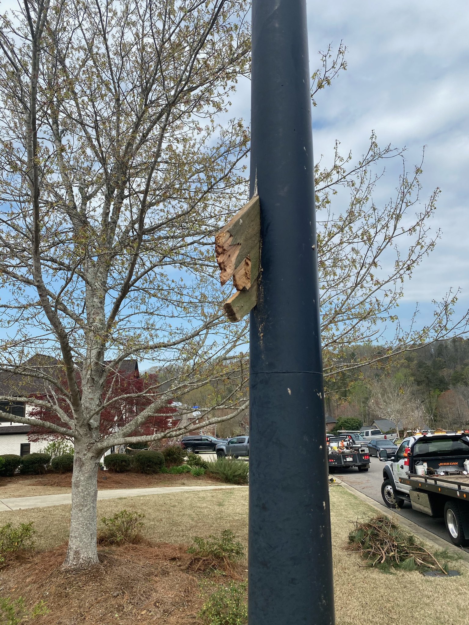
Posted on 3/26/21 at 2:46 pm to Roll Tide Ravens
This picture comes from the Eagle Point neighborhood bit by the southern B’ham metro tornado. A piece of wood impaled this metal light pole.
Posted on 3/26/21 at 3:53 pm to Roll Tide Ravens
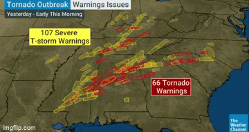
9 Tornado Emergencies were issued yesterday. That's wild, and a testament to the areas these storms tracked through.

Posted on 3/26/21 at 4:03 pm to LegendInMyMind

 Page 67 of 86

Popular
Back to top