- My Forums
- Tiger Rant
- LSU Recruiting
- SEC Rant
- Saints Talk
- Pelicans Talk
- More Sports Board
- Coaching Changes
- Fantasy Sports
- Golf Board
- Soccer Board
- O-T Lounge
- Tech Board
- Home/Garden Board
- Outdoor Board
- Health/Fitness Board
- Movie/TV Board
- Book Board
- Music Board
- Political Talk
- Money Talk
- Fark Board
- Gaming Board
- Travel Board
- Food/Drink Board
- Ticket Exchange
- TD Help Board
Customize My Forums- View All Forums
- Show Left Links
- Topic Sort Options
- Trending Topics
- Recent Topics
- Active Topics
Started By
Message
re: Tuesday Severe weather for the Gulf Coast/Snowstorm for Arkansas
Posted on 1/24/23 at 4:48 pm to Bobby OG Johnson

Posted on 1/24/23 at 4:48 pm to Bobby OG Johnson
Preemptive heads up in DeQuincy. This bookend vortex is ramping up and dropping tornadoes heading that way.
 2
2

Posted on 1/24/23 at 4:50 pm to The Boat
Wife: Maybe we can watch a movie since it'll be raining this evening.
Me: Sure.
tBoat:
Me: Sure.
tBoat:
quote:
QLCS tornadogenesis porn
Posted on 1/24/23 at 4:55 pm to The Boat
Big Woods (SE of Starks) may get a direct hiy shortly.

Posted on 1/24/23 at 4:56 pm to wileyjones
quote:
shell refinery operators are in for a fun afternoon..
It’s Pemex now, but yeah. Flares were all lit up.
This was on Spencer just east of BW8. Bunch of houses with roofs torn up in the neighborhoods. Looks like it missed a mobile home park I passed by about a 1/4 mile. Fire trucks, ambulances, police all over. Might have been worse further into Pasadena, this would be right where it was first ID’d on the ground and not just by radar.


Posted on 1/24/23 at 5:01 pm to The Boat
every storm ahead of the main line is showing rotation
Posted on 1/24/23 at 5:02 pm to LPLGTiger
We are lucky the surface low is this far south and not farther north keeping most of the warm sector over the Gulf. The amount of supercells over the water is crazy. With the low farther north these could be over land. Insane amount of shear.
Got enough trouble as it is

Got enough trouble as it is

Posted on 1/24/23 at 5:08 pm to The Boat
I just got a tornado warning message. Do you have any idea where that may be?

Posted on 1/24/23 at 5:09 pm to SlowFlowPro
I'm in Lake Chuck and got the warning
Posted on 1/24/23 at 5:10 pm to The Boat
quote:
Preemptive heads up in DeQuincy. This bookend vortex is ramping up and dropping tornadoes heading that way.
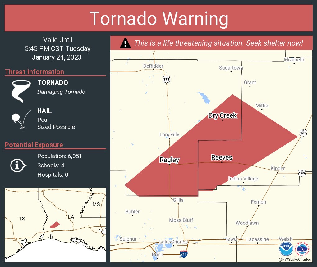
Tornado on the ground SE of DeQuincy heading towards Reeves

Posted on 1/24/23 at 5:11 pm to SlowFlowPro
Could it be the one around edgerly road near vinton? That’s what KPLC has up.
Posted on 1/24/23 at 5:11 pm to SlowFlowPro
quote:
I just got a tornado warning message. Do you have any idea where that may be?
If there's anything it's near 210 heading towards downtown but I don't think there's anything on the ground.
The tornado near DeQuincy is bad
Posted on 1/24/23 at 5:12 pm to The Boat
PDS Tornado Warning in SWLA
Posted on 1/24/23 at 5:12 pm to The Boat
PDS warning for the Tornado heading to US 171 S of Ragley near Gaytine.
This post was edited on 1/24/23 at 5:13 pm
Posted on 1/24/23 at 5:12 pm to sledgehammer


Posted on 1/24/23 at 5:13 pm to Bobby OG Johnson
Posted on 1/24/23 at 5:16 pm to Bobby OG Johnson
Lake Charles is in the clear other than a few minutes of heavy rain. After it passes the threat is over.
Posted on 1/24/23 at 5:18 pm to The Boat
quote:
Lake Charles is in the clear other than a few minutes of heavy rain. After it passes the threat is over.
That's great news.
Posted on 1/24/23 at 5:19 pm to Bobby OG Johnson
Continued

Posted on 1/24/23 at 5:20 pm to SOLA
Confirmed large and extremely dangerous tornado between DeQuincy and Reeves.
Posted on 1/24/23 at 5:22 pm to Roll Tide Ravens
quote:
Confirmed large and extremely dangerous tornado between DeQuincy and Reeves.
You could see that bookend vortex cranking up all the way back before Orange, Tx more than 45 minutes ago. Only a matter of time before it put a big one down.

 Page 10 of 28

Popular
Back to top