- My Forums
- Tiger Rant
- LSU Recruiting
- SEC Rant
- Saints Talk
- Pelicans Talk
- More Sports Board
- Coaching Changes
- Fantasy Sports
- Golf Board
- Soccer Board
- O-T Lounge
- Tech Board
- Home/Garden Board
- Outdoor Board
- Health/Fitness Board
- Movie/TV Board
- Book Board
- Music Board
- Political Talk
- Money Talk
- Fark Board
- Gaming Board
- Travel Board
- Food/Drink Board
- Ticket Exchange
- TD Help Board
Customize My Forums- View All Forums
- Show Left Links
- Topic Sort Options
- Trending Topics
- Recent Topics
- Active Topics
Started By
Message
re: Tropical Storm Claudette - Heading Out Sea
Posted on 6/19/21 at 1:11 am to Bobby OG Johnson

Posted on 6/19/21 at 1:11 am to Bobby OG Johnson
Yeah, no sleep here with the phone popping off for every tornado warning in Hancock County.
 2
2


Posted on 6/19/21 at 1:16 am to RummelTiger
quote:
no sleep here in Hancock
Only one thing left to do
Posted on 6/19/21 at 1:20 am to The Boat
quote:
Only one thing left to do
Watch Friends?

Posted on 6/19/21 at 2:05 am to GreenRockTiger
quote:
I’m in Baton Rouge — where do I meet you
married with 12 kids
Posted on 6/19/21 at 2:49 am to The Boat
Keep up the good work boat
Posted on 6/19/21 at 3:09 am to Adam4848
Flooding is bad in Pass Christian. There’s at least a foot of water under the house right now. Need these torrential downpours to stop for a while.

Posted on 6/19/21 at 3:38 am to RummelTiger
frick..
Posted on 6/19/21 at 4:43 am to LanierSpots
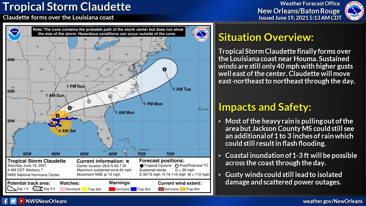
4 am advisory. It has a name now despite being almost on land. Insurance lobby wins, now you have to deal with storm deductibles if you got damage.
WTNT33 KNHC 190858
TCPAT3
BULLETIN
Tropical Storm Claudette Advisory Number 7
NWS National Hurricane Center Miami FL AL032021
400 AM CDT Sat Jun 19 2021
...TROPICAL STORM CLAUDETTE FORMS...
...HEAVY RAINFALL CAUSING DANGEROUS FLOODING REMAINS THE PRIMARY
HAZARD...
SUMMARY OF 400 AM CDT...0900 UTC...INFORMATION
----------------------------------------------
LOCATION...29.6N 90.7W
ABOUT 45 MI...75 KM SW OF NEW ORLEANS LOUISIANA
ABOUT 175 MI...280 KM WSW OF MOBILE ALABAMA
MAXIMUM SUSTAINED WINDS...45 MPH...75 KM/H
PRESENT MOVEMENT...NNE OR 15 DEGREES AT 12 MPH...19 KM/H
MINIMUM CENTRAL PRESSURE...1006 MB...29.71 INCHES
WATCHES AND WARNINGS
--------------------
CHANGES WITH THIS ADVISORY:
None.
SUMMARY OF WATCHES AND WARNINGS IN EFFECT:
A Tropical Storm Warning is in effect for...
* East of Morgan City, Louisiana to the Okaloosa/Walton County line
Florida.
* Lake Pontchartrain, Lake Maurepas, and Metropolitan New Orleans
A Tropical Storm Warning means that tropical storm conditions are
expected somewhere within the warning area.
Interests elsewhere along the northern Gulf Coast should monitor
the progress of this system.
For storm information specific to your area, including possible
inland watches and warnings, please monitor products issued by your
local National Weather Service forecast office.
DISCUSSION AND OUTLOOK
----------------------
At 400 AM CDT (0900 UTC), the center of Tropical Storm Claudette was
located inland near latitude 29.6 North, longitude 90.7 West.
Claudette is moving toward the north-northeast near 12 mph (19
km/h). A turn toward the northeast is expected later today, with a
turn toward the east-northeast expected by tonight or Sunday. On
the forecast track, the system should move farther inland over
Louisiana during the next several hours, then move across portions
of the Gulf coast and southeastern states through the weekend, and
over the western Atlantic Ocean on Monday.
Maximum sustained winds remain near 45 mph (75 km/h) with higher
gusts. Claudette is expected to weaken to a tropical depression by
tonight and become a post-tropical cyclone on Sunday. The system
is forecast to re-develop over the western Atlantic Ocean on Monday.
Tropical-storm-force winds extend outward up to 205 miles (335 km)
from the center.
The estimated minimum central pressure is 1006 mb (29.71 inches).
HAZARDS AFFECTING LAND
----------------------
Key messages for Claudette can be found in the Tropical Cyclone
Discussion under AWIPS header MIATCDAT3, WMO header WTNT43 KNHC,
and on the web at
www.hurricanes.gov/graphics_at3.shtml?key_messages.
RAINFALL: Claudette is expected to produce rainfall totals of 5 to
10 inches with isolated maximum amounts of 15 inches across portions
of the central Gulf Coast. Life-threatening flash flooding impacts
are possible across coastal Mississippi and Alabama, and the far
western Florida Panhandle through the afternoon. Considerable flash,
urban and small stream flooding impacts as well as new and renewed
minor to isolated moderate river flooding are likely across the
remainder of the Central Gulf Coast.
As the system continues to lift northeast through the weekend, heavy
rain will expand across central Alabama, central and northern
Georgia, into the Piedmont of the Carolinas, resulting in rainfall
totals of 3 to 6 inches with isolated maximum amounts of 8 inches.
Flash, urban, small stream and isolated minor river flooding impacts
are possible.
STORM SURGE: The combination of storm surge and the tide will
cause normally dry areas near the coast to be flooded by rising
waters moving inland from the shoreline. The water could reach the
following heights above ground somewhere in the indicated areas if
the peak surge occurs at the time of high tide...
Morgan City, LA to Okaloosa/Walton County Line, FL...2-3 ft
Lake Borgne and Mobile Bay...2-3 ft
Lake Pontchartrain and Lake Maurepas...1-2 ft
Okaloosa/Walton County Line, FL to Panama City, FL...1-2 ft
Pensacola Bay, Choctawhatchee Bay, and Saint Andrew Bay...1-2 ft
Cameron, LA to Morgan City, LA...1-2 ft
Vermilion Bay...1-2 ft
Surge-related flooding depends on the relative timing of the surge
and the tidal cycle, and can vary greatly over short distances. For
information specific to your area, please see products issued by
your local National Weather Service forecast office.
WIND: Tropical storm conditions should continue along the coast in
the warning area today.
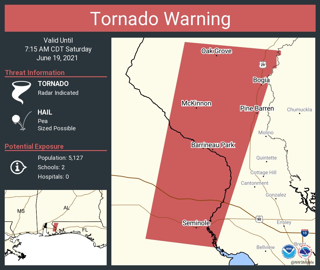
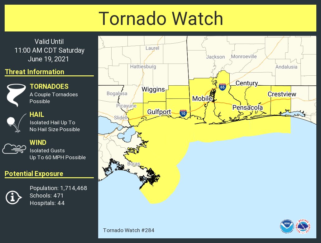
TORNADOES: A few tornadoes are possible today and tonight across
southern Mississippi, southern Alabama, the western Florida
Panhandle, and southwest Georgia.
WTNT33 KNHC 190858
TCPAT3
BULLETIN
Tropical Storm Claudette Advisory Number 7
NWS National Hurricane Center Miami FL AL032021
400 AM CDT Sat Jun 19 2021
...TROPICAL STORM CLAUDETTE FORMS...
...HEAVY RAINFALL CAUSING DANGEROUS FLOODING REMAINS THE PRIMARY
HAZARD...
SUMMARY OF 400 AM CDT...0900 UTC...INFORMATION
----------------------------------------------
LOCATION...29.6N 90.7W
ABOUT 45 MI...75 KM SW OF NEW ORLEANS LOUISIANA
ABOUT 175 MI...280 KM WSW OF MOBILE ALABAMA
MAXIMUM SUSTAINED WINDS...45 MPH...75 KM/H
PRESENT MOVEMENT...NNE OR 15 DEGREES AT 12 MPH...19 KM/H
MINIMUM CENTRAL PRESSURE...1006 MB...29.71 INCHES
WATCHES AND WARNINGS
--------------------
CHANGES WITH THIS ADVISORY:
None.
SUMMARY OF WATCHES AND WARNINGS IN EFFECT:
A Tropical Storm Warning is in effect for...
* East of Morgan City, Louisiana to the Okaloosa/Walton County line
Florida.
* Lake Pontchartrain, Lake Maurepas, and Metropolitan New Orleans
A Tropical Storm Warning means that tropical storm conditions are
expected somewhere within the warning area.
Interests elsewhere along the northern Gulf Coast should monitor
the progress of this system.
For storm information specific to your area, including possible
inland watches and warnings, please monitor products issued by your
local National Weather Service forecast office.
DISCUSSION AND OUTLOOK
----------------------
At 400 AM CDT (0900 UTC), the center of Tropical Storm Claudette was
located inland near latitude 29.6 North, longitude 90.7 West.
Claudette is moving toward the north-northeast near 12 mph (19
km/h). A turn toward the northeast is expected later today, with a
turn toward the east-northeast expected by tonight or Sunday. On
the forecast track, the system should move farther inland over
Louisiana during the next several hours, then move across portions
of the Gulf coast and southeastern states through the weekend, and
over the western Atlantic Ocean on Monday.
Maximum sustained winds remain near 45 mph (75 km/h) with higher
gusts. Claudette is expected to weaken to a tropical depression by
tonight and become a post-tropical cyclone on Sunday. The system
is forecast to re-develop over the western Atlantic Ocean on Monday.
Tropical-storm-force winds extend outward up to 205 miles (335 km)
from the center.
The estimated minimum central pressure is 1006 mb (29.71 inches).
HAZARDS AFFECTING LAND
----------------------
Key messages for Claudette can be found in the Tropical Cyclone
Discussion under AWIPS header MIATCDAT3, WMO header WTNT43 KNHC,
and on the web at
www.hurricanes.gov/graphics_at3.shtml?key_messages.
RAINFALL: Claudette is expected to produce rainfall totals of 5 to
10 inches with isolated maximum amounts of 15 inches across portions
of the central Gulf Coast. Life-threatening flash flooding impacts
are possible across coastal Mississippi and Alabama, and the far
western Florida Panhandle through the afternoon. Considerable flash,
urban and small stream flooding impacts as well as new and renewed
minor to isolated moderate river flooding are likely across the
remainder of the Central Gulf Coast.
As the system continues to lift northeast through the weekend, heavy
rain will expand across central Alabama, central and northern
Georgia, into the Piedmont of the Carolinas, resulting in rainfall
totals of 3 to 6 inches with isolated maximum amounts of 8 inches.
Flash, urban, small stream and isolated minor river flooding impacts
are possible.
STORM SURGE: The combination of storm surge and the tide will
cause normally dry areas near the coast to be flooded by rising
waters moving inland from the shoreline. The water could reach the
following heights above ground somewhere in the indicated areas if
the peak surge occurs at the time of high tide...
Morgan City, LA to Okaloosa/Walton County Line, FL...2-3 ft
Lake Borgne and Mobile Bay...2-3 ft
Lake Pontchartrain and Lake Maurepas...1-2 ft
Okaloosa/Walton County Line, FL to Panama City, FL...1-2 ft
Pensacola Bay, Choctawhatchee Bay, and Saint Andrew Bay...1-2 ft
Cameron, LA to Morgan City, LA...1-2 ft
Vermilion Bay...1-2 ft
Surge-related flooding depends on the relative timing of the surge
and the tidal cycle, and can vary greatly over short distances. For
information specific to your area, please see products issued by
your local National Weather Service forecast office.
WIND: Tropical storm conditions should continue along the coast in
the warning area today.
TORNADOES: A few tornadoes are possible today and tonight across
southern Mississippi, southern Alabama, the western Florida
Panhandle, and southwest Georgia.

Posted on 6/19/21 at 5:12 am to Tarps99
I cannot believe they named it

Posted on 6/19/21 at 5:20 am to geauxtigers87
Insurance companies got dat game.
Posted on 6/19/21 at 5:22 am to TigerBait1971
First thing i thought when I saw they gave it a name just at landfall. Totally an insurance money grab.
Posted on 6/19/21 at 5:35 am to RummelTiger
Went through some real ugly weather last night but looks to be slowing down considerably now.
I didn’t go outside but could hear the rain being blown against the house and I kept a sunbrella up on purpose to see if it would get blown over. It did
I didn’t go outside but could hear the rain being blown against the house and I kept a sunbrella up on purpose to see if it would get blown over. It did
This post was edited on 6/19/21 at 5:53 am
Posted on 6/19/21 at 5:51 am to Tarps99
According to TWC Radar the “center of this storm will be passing about 1/2 from my house in an hour or so. It is now 3 and a half miles SW of me.
The cone line is on the edge of my property line about 200 feet from the house. I think I’ll be safe.
I’m on my dock loading up to go fishing.
The cone line is on the edge of my property line about 200 feet from the house. I think I’ll be safe.
I’m on my dock loading up to go fishing.
This post was edited on 6/19/21 at 5:59 am
Posted on 6/19/21 at 6:11 am to Tarps99
Zero energy anywhere near the eye, the "effective eye" made landfall yesterday evening.

Posted on 6/19/21 at 6:11 am to Bigfishchoupique
Posted on 6/19/21 at 6:12 am to Bobby OG Johnson
Posted on 6/19/21 at 6:22 am to Roll Tide Ravens
quote:
I’m not sure what people were expecting. It was always going to be a weak system with most of the rain displaced east of the center.
Well I can tell you, Jay was doing his best to pump this up Thursday night. He didn’t have his sleeves rolled up yet, but he was emphasizing all the potential bad things that could happen. He wasn’t dismissing it.
Until Friday night
Posted on 6/19/21 at 6:26 am to Bobby OG Johnson
Posted on 6/19/21 at 6:30 am to Bobby OG Johnson


 Page 65 of 72

Popular
Back to top