- My Forums
- Tiger Rant
- LSU Recruiting
- SEC Rant
- Saints Talk
- Pelicans Talk
- More Sports Board
- Coaching Changes
- Fantasy Sports
- Golf Board
- Soccer Board
- O-T Lounge
- Tech Board
- Home/Garden Board
- Outdoor Board
- Health/Fitness Board
- Movie/TV Board
- Book Board
- Music Board
- Political Talk
- Money Talk
- Fark Board
- Gaming Board
- Travel Board
- Food/Drink Board
- Ticket Exchange
- TD Help Board
Customize My Forums- View All Forums
- Show Left Links
- Topic Sort Options
- Trending Topics
- Recent Topics
- Active Topics
Started By
Message
re: Tropical Storm Claudette - Heading Out Sea
Posted on 6/17/21 at 7:37 am to rds dc
Posted on 6/17/21 at 7:37 am to rds dc
Not much change in thinking with models showing 4-6"+ of rain for areas eaat of the "track"

This will probably get a name in the Gulf but it's likely going to struggle as the upper level environment looks pretty hostile up through landfall. The exiting trough leaves an upper low over Texas and the system looks to stay tangled up with all of that.

This will probably get a name in the Gulf but it's likely going to struggle as the upper level environment looks pretty hostile up through landfall. The exiting trough leaves an upper low over Texas and the system looks to stay tangled up with all of that.
This post was edited on 6/18/21 at 6:59 am
 2
2

Posted on 6/17/21 at 8:13 am to rds dc
Why are the spaghetti models so different from the operational models right now? No defined center?
The TVCN has this thing going almost to Brownsville
The TVCN has this thing going almost to Brownsville
Posted on 6/17/21 at 8:24 am to Midtiger farm
quote:
Why are the spaghetti models so different from the operational models right now? No defined center?
The TVCN has this thing going almost to Brownsville
I don't really look at them but some ensemble trackers are picking up on a vort in the BOC that tracks inland and towards the Pacific. So we are getting stuff like this:

This post was edited on 6/17/21 at 8:29 am

Posted on 6/17/21 at 8:52 am to rds dc
Looks like the center moves over SE LA and all the rain goes over Mobile and the Fla panhandle.
Posted on 6/17/21 at 9:06 am to TheHarahanian
Y’all thinking this is going to move through quickly? Have a trip planned to Aubur...I mean Punta Cana on Monday and am wondering if I need to reschedule.
Posted on 6/17/21 at 9:54 am to StringedInstruments
So these seem very different.


Posted on 6/17/21 at 10:31 am to TheHarahanian
quote:
Looks like the center moves over SE LA and all the rain goes over Mobile and the Fla panhandle.
Appears BR and surrounding areas will get 4 to 6" over Friday and Sat?
Posted on 6/17/21 at 10:33 am to Mystictiger
This "storm" hasn't developed yet. Any track until it does is pretty speculative.
Posted on 6/17/21 at 10:38 am to rds dc
looks like there might be a sharp rainfall gradient from this, all the rain will be far to the east of the circulation with the circulation being nearly dry, then a near due north track as it goes inland
Posted on 6/17/21 at 11:00 am to Impotent Waffle
quote:
will get 4 to 6" over Friday and Sat
Leave your weekend plans out of this

Posted on 6/17/21 at 11:27 am to Impotent Waffle
quote:
Appears BR and surrounding areas will get 4 to 6" over Friday and Sat?
More like 7.
Posted on 6/17/21 at 11:33 am to TigerstuckinMS
quote:
Y’all thinking this is going to move through quickly? Have a trip planned to Aubur...I mean Punta Cana on Monday and am wondering if I need to reschedule.
It’s going to be at worst a very minimal TS with a few inches of rain. I’ll will be over by Sunday morning like a summer afternoon rain storm
Posted on 6/17/21 at 11:38 am to purple18
Is it going to be a washout in BR tomorrow and saturday? When should the rain begin in BR?
Posted on 6/17/21 at 11:38 am to rds dc
12z GFS 24Hr Accumulated Rainfall through the 22nd:
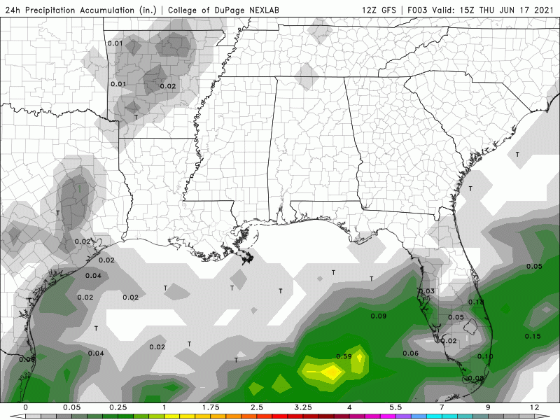
Pretty similar to previous runs, but with the hook East a bit farther North this run. This also shows more lingering rain on the backside of the system than previous runs.
Pretty similar to previous runs, but with the hook East a bit farther North this run. This also shows more lingering rain on the backside of the system than previous runs.
Posted on 6/17/21 at 11:44 am to StringedInstruments
quote:
Y’all thinking this is going to move through quickly? Have a trip planned to Aubur...I mean Punta Cana on Monday and am wondering if I need to reschedule.
We literally have thunderstorms that are worse than this. The majority of Louisiana will get rain, but 4-6 inches of 48-72 hours isn't out of the norm.

Posted on 6/17/21 at 11:45 am to TheAstroTiger
quote:
but 4-6 inches of 48-72 hours isn't out of the norm.
Twss

Posted on 6/17/21 at 11:52 am to LegendInMyMind
quote:Oh, snap. Looks like the majority of the rain won't be coming through until after this NOLA wedding tomorrow evening.
12z GFS 24Hr Accumulated Rainfall through the 22nd:
Alanis Morissette ON [OFF]
Posted on 6/17/21 at 11:53 am to jaytothen
quote:
Leave your weekend plans out of this ?
Well damn it, I walked right into that one.....
Posted on 6/17/21 at 11:54 am to LegendInMyMind
12z GFS Total Accumulated Precip through the 22nd. This is for all the rain that could fall between now and the 22nd, not what I have been posting which is the 24Hr accumulations.

Posted on 6/17/21 at 11:55 am to When in Rome
quote:
Oh, snap. Looks like the majority of the rain won't be coming through until after this NOLA wedding tomorrow evening.
Yeah, most of tomorrow looks okay as far as rain goes. Saturday will probably be a washout.

 Page 42 of 72

Popular
Back to top