- My Forums
- Tiger Rant
- LSU Recruiting
- SEC Rant
- Saints Talk
- Pelicans Talk
- More Sports Board
- Fantasy Sports
- Golf Board
- Soccer Board
- O-T Lounge
- Tech Board
- Home/Garden Board
- Outdoor Board
- Health/Fitness Board
- Movie/TV Board
- Book Board
- Music Board
- Political Talk
- Money Talk
- Fark Board
- Gaming Board
- Travel Board
- Food/Drink Board
- Ticket Exchange
- TD Help Board
Customize My Forums- View All Forums
- Show Left Links
- Topic Sort Options
- Trending Topics
- Recent Topics
- Active Topics
Started By
Message
re: TORNADO!!! Pine Belt Tornado preliminary rating of EF-4 with 1 fatality
Posted on 4/19/20 at 4:48 pm to Bobby OG Johnson
Posted on 4/19/20 at 4:48 pm to Bobby OG Johnson
That's between Montgomery and Birmingham for those who don't know
 2
2

Posted on 4/19/20 at 4:51 pm to East Coast Band
Storms starting to erupt between Baton Rouge and North of Lafayette
Posted on 4/19/20 at 4:52 pm to East Coast Band

Posted on 4/19/20 at 4:55 pm to Paul Allen
quote:
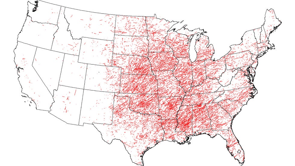
Does the Gulf of Mexico help south of I-10 when it comes to the severity and frequency of tornadoes? Seems like Cen LA north and same with MS seem to always get it worse.
Well, going by this map of the tracks of reported U.S. tornadoes from 1950 through 2014, something helps.
That map brings up an interesting weather discussion: As a geomatics "person" by major and by trade, and therefore a lover of maps and geospatial trends, what always amazed me about tornado tracks is not just how they tend to be clustered in the macro sense of geography where trends and reasons can be more easily identified on a continental scale, but also in how they are clustered on the micro scale and most importantly, why?
Below is a University of Illinois link that has the Esri "Tornado Tracks Tool" map embedded on the page. Geographically speaking for many areas of Mississippi, tornado paths as well as their "points of beginning," especially regarding EF3+ tornadoes, tend to be clustered in the same particular areas relative to the surrounding ones. It is geospatial prevalence that's hard to ignore. Esri "Tornado Track Tool" Map-U of Illinois
What I'm saying is that the geographic distribution of large tornadoes is not nearly as random as one would assume- not in many parts of Mississippi, at least.
An example is a rural community located within Choctaw County, Mississippi. In watching the weather over the years and to whom the meteorologists say are under the gun during any given weather event, one name always pops up: the Chester community. I've been through there many times with work and it's extremely rural, and that's good because they always seem to have a generational tornado or two swing through their area. The rest of the county is relatively untouched by violent tornadoes:

Likewise, the county to the southwest, that is Attala county, is the same way, as are most other MS counties: Large, violent, long-track tornadoes tend to follow the same paths like some sort of microclimate set of conditions decides their fate and the fate of the poor souls who live downrange. Even more striking is that large tornadoes in Attala County Mississippi start their dance in a pretty well defined & concentrated area, geographically speaking, but Attala county is not "special" in that sense: The concentration of points where a storm says, "This is a good place to start." is another fairly common geospatial occurrence (albeit less so than the prevalence of serial tornado corridors):

I'm not saying there aren't outliers or that there aren't poor SOB's like those in Kemper County where no one is safe (see pic below), but overall this phenomena tends to repeat itself over and over throughout the state: The collision of air masses might be what makes Mississippi home for tornadoes in April, but what makes the northeast corner of Attala county Mississippi so peculiarly attractive? And speaking of Kemper County, statistically and geospatially speaking, save that one pesky EF4 down at the bottom, you're in much better shape to be in the southern half of the county rather than the northern one judging by a visual study of the county map:

Ever since noticing this trend in my own home area (and having Esri pretty much verify it) of the clustering of points where storms not only tend to spawn violent tornadoes, but also where storms are moving in what I call a "volatile corridor," I've always paid extra close attention to any dangerous thunderstorms that are doing just that: Moving into those areas where, statistically speaking, they are as likely as ever to send a wedge my way.
An example of what I mean is this:
If I'm in Chester, Mississippi on April 27th and there are dangerous tornadic storms on the brink of putting a tornado on the ground all around me and they're moving in the same azimuthal direction as those in the pic (instead of a more horizontal or vertical path), but of all of the storms one moves into the community of that quadrant in Attala county to my southwest that tends to send big ones my way, then I'm paying damned close attention to it- more so than the others.
Assuming that these statistical trends could be scientifically identified and verified (and I feel they could using GIS analysis), I've always felt that if cartographers, GIS analysts and meteorologists teamed up to identify "super at-risk corridors" and integrated them in with the other forecasting and warning systems, especially on a local scale, then it might help save a life, because I know this much: If I were looking for a new property in which to build a home within the county where I currently reside, then there are a couple of specific communities where I wouldn't DREAM of building a home without the finest in-home shelter that money could buy. They have too many close calls until eventually they take a direct hit.
Posted on 4/19/20 at 4:57 pm to Bigbee Hills

This post was edited on 4/19/20 at 4:57 pm
Posted on 4/19/20 at 4:58 pm to blake243
quote:
The alexandria market hasnt really covered us very well over the last year or so sports or weather... monroe has been more reliable
I miss Adaleigh Rowe
Posted on 4/19/20 at 4:59 pm to lsuman25

Posted on 4/19/20 at 5:00 pm to rt3

Posted on 4/19/20 at 5:00 pm to Hurricane Mike
Adaleigh left?
Posted on 4/19/20 at 5:00 pm to rt3
going right for the radar
Posted on 4/19/20 at 5:00 pm to rt3
yo... this tornado warning that just popped up in CenLA could end up threatening Alexandria
Posted on 4/19/20 at 5:04 pm to rt3


Posted on 4/19/20 at 5:04 pm to rt3

Posted on 4/19/20 at 5:08 pm to Bobby OG Johnson

Posted on 4/19/20 at 5:11 pm to rt3


Posted on 4/19/20 at 5:12 pm to rt3
My dad just called and said they're huddled up in the bathroom. Leesville / Anacoco area.
This post was edited on 4/19/20 at 5:14 pm
Posted on 4/19/20 at 5:12 pm to rt3

Posted on 4/19/20 at 5:17 pm to rt3
Ft. Polk radar is still active at the moment... so that's good 
Posted on 4/19/20 at 5:19 pm to rt3

Posted on 4/19/20 at 5:20 pm to rt3
So dumb question here....l. I've seen you all post all of these warning and there have been many. Are none of these touching down? I'm sure it's kind of soon for much of the pics to start coming in, but I'm curious.

 Page 17 of 34

Popular
Back to top