- My Forums
- Tiger Rant
- LSU Recruiting
- SEC Rant
- Saints Talk
- Pelicans Talk
- More Sports Board
- Coaching Changes
- Fantasy Sports
- Golf Board
- Soccer Board
- O-T Lounge
- Tech Board
- Home/Garden Board
- Outdoor Board
- Health/Fitness Board
- Movie/TV Board
- Book Board
- Music Board
- Political Talk
- Money Talk
- Fark Board
- Gaming Board
- Travel Board
- Food/Drink Board
- Ticket Exchange
- TD Help Board
Customize My Forums- View All Forums
- Show Left Links
- Topic Sort Options
- Trending Topics
- Recent Topics
- Active Topics
Started By
Message
 0
0

Posted on 12/10/21 at 11:02 pm to pioneerbasketball
Mostly standard squall lines?
Posted on 12/10/21 at 11:02 pm to pioneerbasketball
quote:
what do yall make of this?
QLCS(s), nice bookend vort near England. The bow earned the severe warning. This is what is expected, but there is a ton of potential for quick tornadoes in those line, stay aware.
Also, very suspicious cell near Quitman.

Posted on 12/10/21 at 11:02 pm to Bobby OG Johnson

Posted on 12/10/21 at 11:02 pm to Impotent Waffle
And The Weather Channel has ended their live coverage…
Posted on 12/10/21 at 11:03 pm to Duke
quote:
nice bookend vort
My new obsession and I haven't even been able to look for any tonight.

Posted on 12/10/21 at 11:03 pm to pioneerbasketball
quote:
Someone posted that everything was demolished if it didn't have a concrete foundation.
Be careful on these reports. Several reported the courthouse was leveled in Mayfield and obviously was not.
Posted on 12/10/21 at 11:04 pm to Bobby OG Johnson
Posted on 12/10/21 at 11:04 pm to Roll Tide Ravens
quote:
And The Weather Channel has ended their live coverage…
Maybe they did it at the top of the hour to have a midnight crew change. They are on Eastern time.
Posted on 12/10/21 at 11:04 pm to Bobby OG Johnson

Posted on 12/10/21 at 11:04 pm to tWildcat
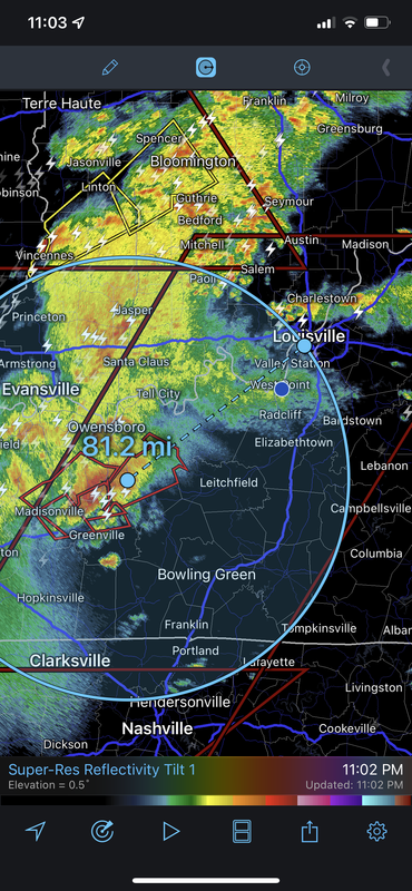
quote:
It just keeps getting closer and closer to Louisville.
Any local Louisville stations going live?

Posted on 12/10/21 at 11:05 pm to Roll Tide Ravens
quote:
And The Weather Channel has ended their live coverage…
Watch Fox Weather. Download the fox weather app on your phone, or the foxnow app in your smart tv, also available in tubi
Posted on 12/10/21 at 11:05 pm to Bobby OG Johnson
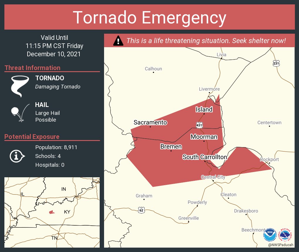
quote:
DISCUSSION...The long-track supercell, now entering Hopkins county,
Kentucky, has now had a nearly continuous TDS for over 3 hours with
an average vRot over 70 knots. The radar presentation and downstream
environment does not show any sign of weakening this storm in the
near term. In fact, recent observations ahead of this supercell have
shown temperature increases of 2 to 3 F and dewpoint increases of 2
to 3F. This, combined with the cooling temperatures aloft, has
actually increased instability ahead of this storm over the last 2
hours. Warm sector winds have veered slightly in the last hour which
has reduced low-level shear slightly. However, there is still
significant turning between the surface and the southwesterly
low-level jet, and therefore, despite this slightly weaker shear, it
likely won't have much of an impact on storm tornadic potential.
The likely catalysts for weakening this long-lived tornadic
supercell will be eventual movement into low to mid 60s dewpoints
and weaker instability, or storm interference as the storms to the
west catch up with the lead supercell. Neither of these are expected
to have an impact in the next hour, but may bring some reprieve
after 06Z.
Well that's a nightmare of a MCD.
Posted on 12/10/21 at 11:05 pm to LegendInMyMind
Over 100 people are trapped in the Amazon facility with at least 2 confirmed deaths
Posted on 12/10/21 at 11:05 pm to SATNIGHTS
Anybody have a live news feed for the one that's still going heading towards louisville?

Posted on 12/10/21 at 11:06 pm to LaBR4
I’ve got family in anchorage and Louisville asleep right now so I’m not getting any sleep in honor of them
Posted on 12/10/21 at 11:06 pm to LaBR4
quote:
Any local Louisville stations going live?
WAVE3
I have their link like a page or 2 back
Posted on 12/10/21 at 11:06 pm to LaBR4
Posted on 12/10/21 at 11:06 pm to Impotent Waffle
quote:
Please excuse the accidental downvote
FYI…refresh, change vote, refresh, fixed
Posted on 12/10/21 at 11:06 pm to tWildcat
thanks

 Page 39 of 90

Back to top