- My Forums
- Tiger Rant
- LSU Recruiting
- SEC Rant
- Saints Talk
- Pelicans Talk
- More Sports Board
- Fantasy Sports
- Golf Board
- Soccer Board
- O-T Lounge
- Tech Board
- Home/Garden Board
- Outdoor Board
- Health/Fitness Board
- Movie/TV Board
- Book Board
- Music Board
- Political Talk
- Money Talk
- Fark Board
- Gaming Board
- Travel Board
- Food/Drink Board
- Ticket Exchange
- TD Help Board
Customize My Forums- View All Forums
- Show Left Links
- Topic Sort Options
- Trending Topics
- Recent Topics
- Active Topics
Started By
Message
re: Tornado outbreak, 94 dead, Upwards of 100 unaccounted for search/rescue & cleanup ongoing
Posted on 12/8/21 at 8:58 pm to LegendInMyMind
Posted on 12/8/21 at 8:58 pm to LegendInMyMind
NO RDS NO CARE.
No offense. You do good work. But he’s the Jedi Master when it comes to weather.
No offense. You do good work. But he’s the Jedi Master when it comes to weather.
 1
1

Posted on 12/8/21 at 9:18 pm to tigerinthebueche
quote:
NO RDS NO CARE.
No offense. You do good work. But he’s the Jedi Master when it comes to weather.
Fair enough. It doesn't change anything, though.
Posted on 12/8/21 at 9:24 pm to LegendInMyMind
I was on the windy app looking at models in AK when I accidently moved the model focus to the middle of America.
It doesn't take a weather guy to look at the models in the windy app to see the setup can be conducive for a strong storm system.
The pretty strong SW flow from the Gulf/Texas area in combination with a pretty strong low moving across the upper miss valley.
Even my coworker saw the set up and was like damn that might be bad
This post was edited on 12/8/21 at 9:26 pm
Posted on 12/8/21 at 9:39 pm to gaetti15
How have you enjoyed the freezer lately?
Posted on 12/8/21 at 10:07 pm to LegendInMyMind
The weather this month has been fricking disgusting. Mid 80s in December? Son of a bitch.
Posted on 12/8/21 at 10:45 pm to LegendInMyMind
Dont care for the southern shortwave getting rotated around.
Posted on 12/8/21 at 10:53 pm to LegendInMyMind
Looks like I’m in for a ride Friday evening
And to think I wasn’t gonna drink this weekend
And to think I wasn’t gonna drink this weekend
Posted on 12/8/21 at 11:25 pm to deltaland
quote:
Looks like I’m in for a ride Friday evening
And to think I wasn’t gonna drink this weekend

Posted on 12/9/21 at 1:14 am to LegendInMyMind
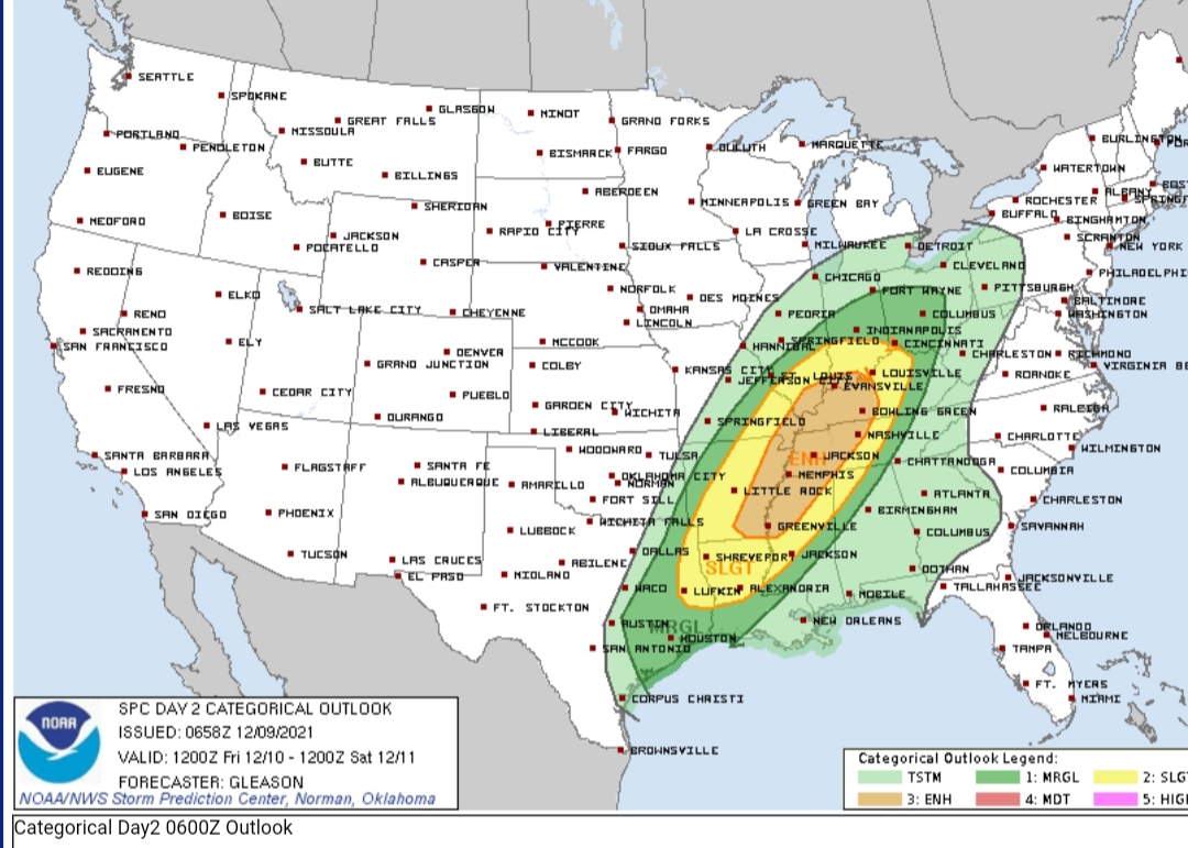
Enhanced on the board D2.
The most interesting/concerning bit of the discussion:
Thunderstorms
may develop ahead of the cold front along one or more pre-frontal
confluence bands late Friday evening. If this occurs, then a broken
band of supercells may develop, with additional thunderstorms
forming later along the cold front farther west.
Posted on 12/9/21 at 1:37 am to Duke
Yep.
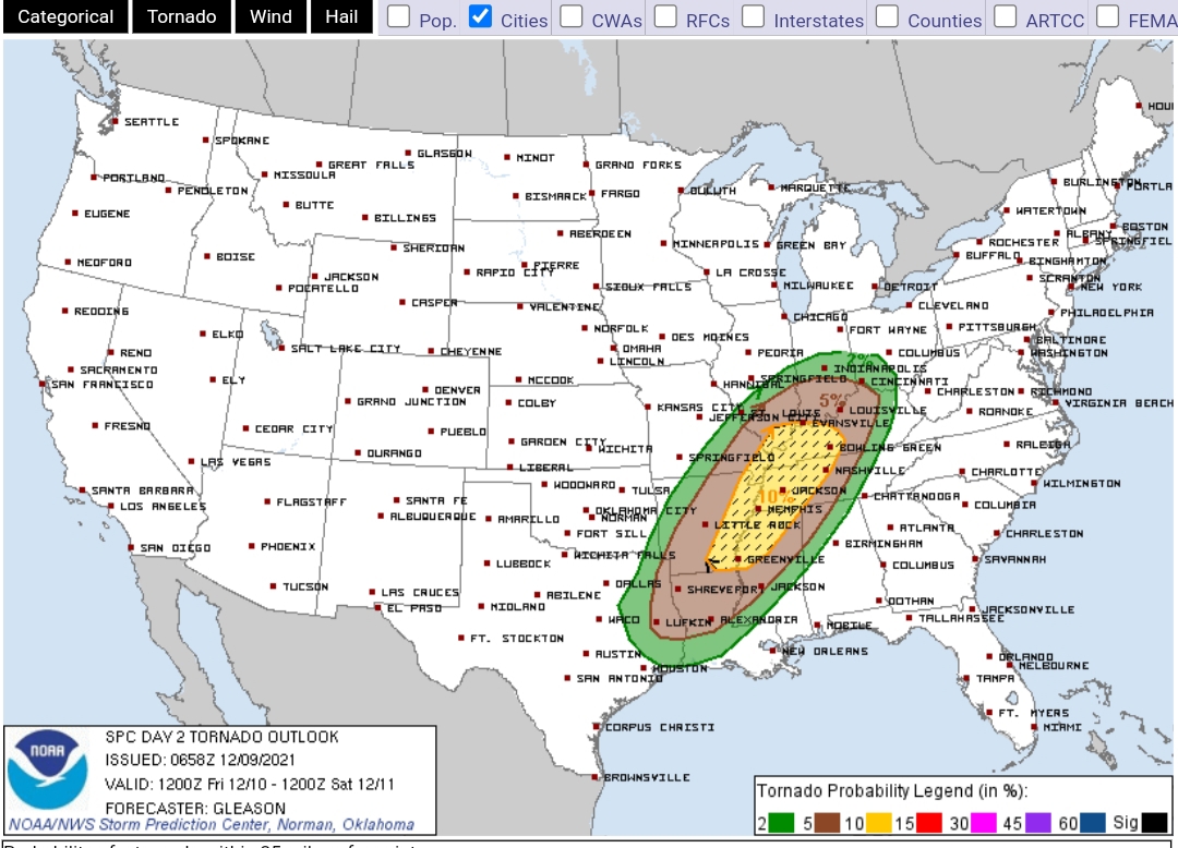
10% hatched for tornadoes:
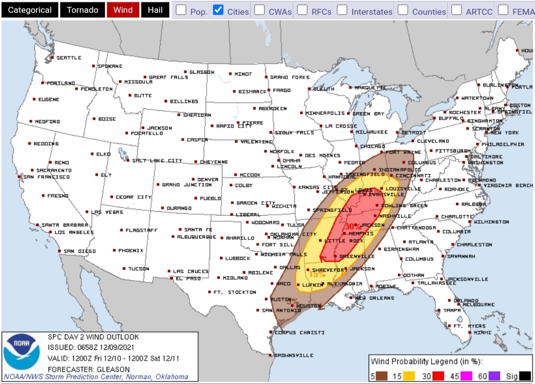
30% wind:
And by the sound of the discussion they are on board with the earlier/pre-line storm mode. Makes sense with the 06z HRRR not backing off on firing that convection.
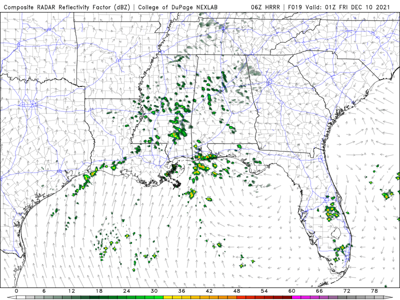
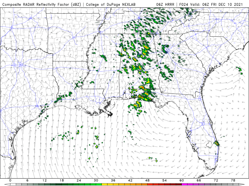
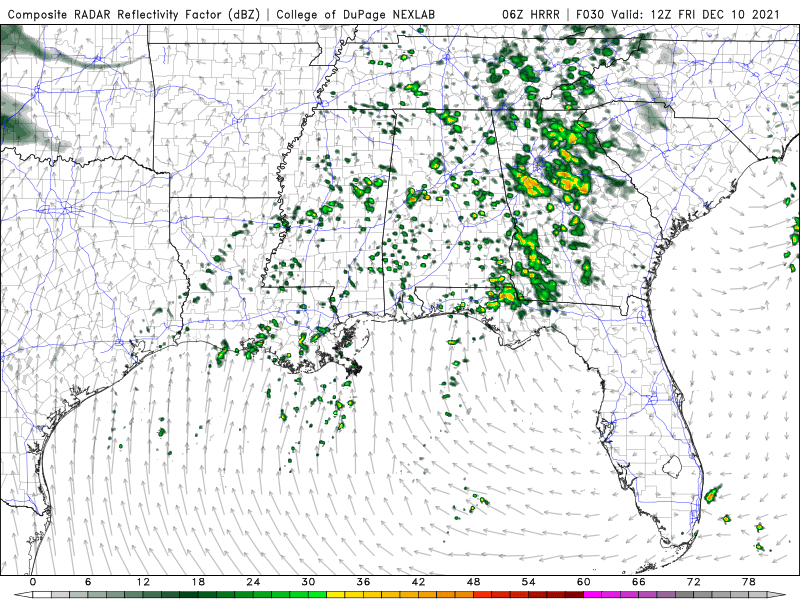
Fairly well distributed across the warm sector, too, before even a hint of the QLCS forming.
10% hatched for tornadoes:
30% wind:
And by the sound of the discussion they are on board with the earlier/pre-line storm mode. Makes sense with the 06z HRRR not backing off on firing that convection.
Fairly well distributed across the warm sector, too, before even a hint of the QLCS forming.
This post was edited on 12/9/21 at 2:07 am
Posted on 12/9/21 at 2:07 am to LegendInMyMind
Ive been focused on the local (to me) impacts vs what is out in front. There's going to be a shortwave ejecting out of the south while the main through swings out of the Rockies.
That energy is what has been flexing the trough the last few runs and could reasonably have some storms fire from a little bit of lift provided, ahead of the trough bringing the real shear.
That energy is what has been flexing the trough the last few runs and could reasonably have some storms fire from a little bit of lift provided, ahead of the trough bringing the real shear.
Posted on 12/9/21 at 2:34 am to LegendInMyMind
quote:
QLCS forming
What’s this?
Posted on 12/9/21 at 5:36 am to CCT
QLCS:
Quick spin up tornadoes along a line of storms. They can be brief or a few minutes. Still can cause damage. Always look for that inflow notch on the leading edge of that line of storms.
Oklahoma went through an October for the books when it came to tornadic storms.
Quick spin up tornadoes along a line of storms. They can be brief or a few minutes. Still can cause damage. Always look for that inflow notch on the leading edge of that line of storms.
Oklahoma went through an October for the books when it came to tornadic storms.

Posted on 12/9/21 at 6:28 am to LegendInMyMind
cool. i didn't want to see the sun this week anyways

Posted on 12/9/21 at 7:07 am to Oklahomey
QLCS: Quasi-Linear Convective System
Quasi-Linear: (Almost) A line
Convective System: Thunderstorms
QLCS: A scientific way of saying a line of thunderstorms
Quasi-Linear: (Almost) A line
Convective System: Thunderstorms
QLCS: A scientific way of saying a line of thunderstorms
This post was edited on 12/9/21 at 7:08 am
Posted on 12/9/21 at 7:08 am to LegendInMyMind
This is one of those lines that they make a huge arse deal about because there's no significant thing for weather people to focus on this time of year.
Will be a nothing burger and they'll look stupid.
Will be a nothing burger and they'll look stupid.
Posted on 12/9/21 at 8:26 am to LegendInMyMind
Enhanced area looks too far north if you compare to the convection of the HRRR

Posted on 12/9/21 at 8:39 am to Briella
quote:
Quasi-Linear

Posted on 12/9/21 at 12:02 pm to Briella
One of our new high res models (FV3) is coming in hot on supercells. Might be a little too warm at the surface but at the same time, youre generally going to have a cold surface bias on models this time of year.
Posted on 12/9/21 at 2:55 pm to Duke
I'm thinking that even if we don't see alot of cells pre-line that the line is going to be fairly broken with supercell characteristics, at least for a while.
I pulled a sounding on the NAM on one of the cells way out in front in central AL and the hodo looked good. Of course, almost any sounding you pull will show tornado at this point.
I pulled a sounding on the NAM on one of the cells way out in front in central AL and the hodo looked good. Of course, almost any sounding you pull will show tornado at this point.

 Page 2 of 90

Popular
Back to top