




- My Forums
- Tiger Rant
- LSU Recruiting
- SEC Rant
- Saints Talk
- Pelicans Talk
- More Sports Board
- Fantasy Sports
- Golf Board
- Soccer Board
- O-T Lounge
- Tech Board
- Home/Garden Board
- Outdoor Board
- Health/Fitness Board
- Movie/TV Board
- Book Board
- Music Board
- Political Talk
- Money Talk
- Fark Board
- Gaming Board
- Travel Board
- Food/Drink Board
- Ticket Exchange
- TD Help Board
Customize My Forums- View All Forums
- Show Left Links
- Topic Sort Options
- Trending Topics
- Recent Topics
- Active Topics
Started By
Message

 1
1


Posted on 1/21/17 at 5:49 pm to NorthEndZone
quote:
A bit of a hook on that cell just SW of Lutcher. Take cover if you are near there just in case.
Yeah those cells have just kind of sat there for the past half hour. No rotation yet though, thankfully.

Posted on 1/21/17 at 5:51 pm to NorthEndZone
quote:
Very small town that is one of the perennial powers in high school basketball in Class C.
These tornado threads have a way of turning into a who's who of 1-A or lower sports powerhouses, especially in northern LA.
Posted on 1/21/17 at 5:51 pm to slackster
If there is any hail in that one it is right over Airline highway in Gramercy now.

Posted on 1/21/17 at 5:52 pm to slackster
I absolutely hate days like this. 5+ hours of my butthole clinched watching the radars 
Posted on 1/21/17 at 5:57 pm to chinhoyang
quote:
I could sit outside and watch the top grow of the tornadic storm headed just south of Natchitoches. Went to get my camera, but some low clouds obscured the shot in the meantime.
That storm is looking pretty interesting. Looks like the original rotation was went away and a new rotation is forming.


Posted on 1/21/17 at 5:59 pm to slackster
Has that classic look to it.
You can see the rear Flank Downdraft strengthing up (the hook).
You can see the rear Flank Downdraft strengthing up (the hook).
Posted on 1/21/17 at 5:59 pm to Duke
Not what you want to see on radar


Posted on 1/21/17 at 6:01 pm to rds dc
Why is that Rds? All those are supercells popping up ahead of the main line?

Posted on 1/21/17 at 6:01 pm to rds dc
They're forming up fast too. Going to be a long night up that way.
ETA: 50, it's those isolated cells that are tornado makers. A line interferes with the inflow. All alone, nothing to impede that warm air inflow.
ETA: 50, it's those isolated cells that are tornado makers. A line interferes with the inflow. All alone, nothing to impede that warm air inflow.
This post was edited on 1/21/17 at 6:03 pm
Posted on 1/21/17 at 6:02 pm to Duke
cell between Lafayette and Baton Rouge has my attention
Posted on 1/21/17 at 6:03 pm to Duke
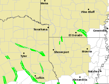
What's my outlook in Shreveport?
Posted on 1/21/17 at 6:03 pm to lsuman25
No rotation yet. Probably going to be a problem toward the state line and into Mississippi.
Posted on 1/21/17 at 6:05 pm to rds dc
quote:
Not what you want to see on radar
Yeah, what most people would just write off as isolated thunderstorms is a bad thing in this environment. You'd rather see a line of magenta stretching across the whole state than a few blobs of red like you do now.

Posted on 1/21/17 at 6:06 pm to Lsuhoohoo
quote:
That storm headed for Springhill got its act together in a hurry.
3 or 4 warnings in a small area but nothing on the ground so far as far as I can tell.

Posted on 1/21/17 at 6:07 pm to Scoop
Crazy that it is all quiet in Shreveport but it all around us
Posted on 1/21/17 at 6:07 pm to rds dc
quote:
Current warnings
Things are blowing up in NW LA so fast that this is already incorrect. Just got a new warning @ 6:04 for Haynesville up into Arkansas.
Posted on 1/21/17 at 6:07 pm to slackster
That tornado was not on the ground in Cotton Valley.
Not sure what it does later.
Not sure what it does later.

 Page 13 of 27

Popular
Back to top
 Follow TigerDroppings for LSU Football News