




- My Forums
- Tiger Rant
- LSU Recruiting
- SEC Rant
- Saints Talk
- Pelicans Talk
- More Sports Board
- Fantasy Sports
- Golf Board
- Soccer Board
- O-T Lounge
- Tech Board
- Home/Garden Board
- Outdoor Board
- Health/Fitness Board
- Movie/TV Board
- Book Board
- Music Board
- Political Talk
- Money Talk
- Fark Board
- Gaming Board
- Travel Board
- Food/Drink Board
- Ticket Exchange
- TD Help Board
Customize My Forums- View All Forums
- Show Left Links
- Topic Sort Options
- Trending Topics
- Recent Topics
- Active Topics
Started By
Message

 1
1



Posted on 1/21/17 at 4:21 pm to dukke v
quote:
What cell... the one north of BR????? Dude give me ONE reason the Baton Rouge area has anything to worry about....
Welp, BR is boned.
Posted on 1/21/17 at 4:26 pm to Duke
Amateur Meteorologists are so fricking pretentious.
We get it, you weren't smart enough to be an actual meteorologist. Stop using the jargon.
We get it, you weren't smart enough to be an actual meteorologist. Stop using the jargon.
Posted on 1/21/17 at 4:28 pm to dukke v
quote:
What cell... the one north of BR?????
He's not talking about BR. He's a weather nerd. He's watching the cell for the sake of watching the cell.
quote:
Dude give me ONE reason the Baton Rouge area has anything to worry about....
Easy. The conditions are such that if a cell gets up and going it will likely go severe and maybe drop a tornado. If one of those comes over BR, might want to worry. The NWS doesn't throw out Tornado Watches for fun.
Peej, I agree it's really unlikely BR sees much impact at all. That doesn't make it "no chance".
Posted on 1/21/17 at 4:33 pm to Chuker
Then stay out the thread if you don't want to read it dumbass

Posted on 1/21/17 at 4:35 pm to Duke
Pretty much lots of volatility in the stuff up my way that I am watching (Arklatex). Different cells are intensifying and de intensifying rapidly. Very fluid.
Posted on 1/21/17 at 4:36 pm to Chuker
quote:
Chuker
Convective Available Potential Energy
Vorticity
Differential wind velocity with height
Temperature Inversion
Negatively Tilted
Lapse Rate
Couplet
Rear Flank Downdraft
Evaporative Cooling

Posted on 1/21/17 at 4:39 pm to Duke
Southeast of Jefferson might get a warning soon. That will be two right next to eachother. It's popping in the arklatex.
West of Mooringsport.
No warning yet but it's spinning and is getting a hook.
West of Mooringsport.
No warning yet but it's spinning and is getting a hook.
This post was edited on 1/21/17 at 4:41 pm
Posted on 1/21/17 at 4:42 pm to Scoop
Arklatex is the spot to watch right now. Those will be dropping some big hail once they mature in that general Moderate area.
Stay safe up there Scoop.
ETA: That southern cell will get a warning soon.
Stay safe up there Scoop.
ETA: That southern cell will get a warning soon.
This post was edited on 1/21/17 at 4:45 pm


Posted on 1/21/17 at 4:44 pm to Duke
I'm in a part of NWLa that's getting the slide by right now from these cells so far. Not under the gun but not by much.
Posted on 1/21/17 at 4:46 pm to rds dc
Yeah. South of the active warning is the one I've been watching for a little bit.
Any time now.
Any time now.
Posted on 1/21/17 at 4:47 pm to Scoop
There it is.

Posted on 1/21/17 at 4:52 pm to slackster
quote:
I don't know if there have been any confirmed tornadoes today as the system from earlier this morning moved across Alabama, GA, and into SC.
I know for certain of one in the town I grew up in. Barnwell, SC had a confirmed tornado a couple of hours ago near highway 78. I'm in Maryland right now and haven't really talked to anyone that way yet to see about the damage. Fortunately hwy 78 in Barnwell is an extremely rural area so it isn't heavily populated.
Posted on 1/21/17 at 4:55 pm to Duke
The way the undercut in the fold should be very concerning the Jefferson area. Look like mid-mass is falconating with the oncoming overwhips.
I'd put the chance of a hurricane hitting the area at 92%
I'd put the chance of a hurricane hitting the area at 92%
Posted on 1/21/17 at 4:58 pm to Chuker
quote:
I'd put the chance of a hurricane hitting the area at 92%
More like 93% you Philistine!
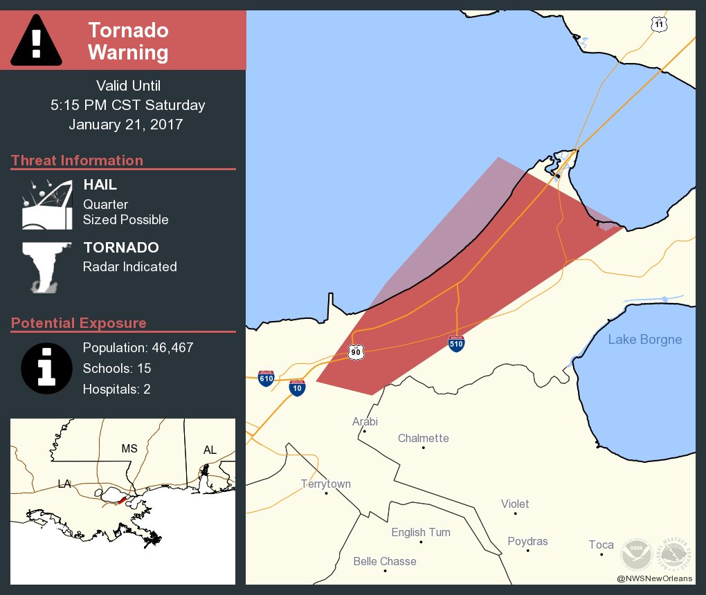
Posted on 1/21/17 at 5:07 pm to rds dc
Nice call PJ!
Posted on 1/21/17 at 5:11 pm to WylieTiger
Yeah he's such a fcktard

 Page 11 of 27

Popular
Back to top
 Follow TigerDroppings for LSU Football News