




- My Forums
- Tiger Rant
- LSU Recruiting
- SEC Rant
- Saints Talk
- Pelicans Talk
- More Sports Board
- Fantasy Sports
- Golf Board
- Soccer Board
- O-T Lounge
- Tech Board
- Home/Garden Board
- Outdoor Board
- Health/Fitness Board
- Movie/TV Board
- Book Board
- Music Board
- Political Talk
- Money Talk
- Fark Board
- Gaming Board
- Travel Board
- Food/Drink Board
- Ticket Exchange
- TD Help Board
Customize My Forums- View All Forums
- Show Left Links
- Topic Sort Options
- Trending Topics
- Recent Topics
- Active Topics
Started By
Message
re: Tornado! Flash Flood Watch & Warnings
Posted on 5/3/17 at 9:00 pm to Dale Doubak
Posted on 5/3/17 at 9:00 pm to Dale Doubak
Flash flood warnings (burgundy color) for basically all of SW Louisiana tonight
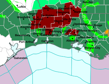
I wouldn't be surprised to see warnings issued for portions of SE Louisiana with cells training off the Gulf out ahead of the main line.
I wouldn't be surprised to see warnings issued for portions of SE Louisiana with cells training off the Gulf out ahead of the main line.
 0
0



Posted on 5/3/17 at 9:00 pm to tigercraig
quote:
BR should be in the clear by 10pm
I'm not sure it's moving that fast, there's still some rain after the big storms move through so my guess is like 1am by the time everything's over.
Looks like MSY is about to shutdown after this flight from Tampa arrives. The flight from DFW just landed to the west which was odd, rest of the flights have been landing to the east or north. Plenty of flights circling now from Philly, Nashville, Charlotte and DC.
ETA: How's our current OT resident Rome doing at the airport? On the plane or waiting in the terminal?
This post was edited on 5/3/17 at 9:02 pm


Posted on 5/3/17 at 9:02 pm to CuseTiger
Can you imagine the turbulence right now?!
Posted on 5/3/17 at 9:03 pm to Paul Allen
Only one time have I landed at MSY when I thought the plane was going down. Landed into a tstorm to the west and the wind was from the north, plane was sideways the entire time until landing
Tampa flight said frick it for landing at MSY, currently on it's way out
Tampa flight said frick it for landing at MSY, currently on it's way out
This post was edited on 5/3/17 at 9:04 pm
Posted on 5/3/17 at 9:04 pm to CuseTiger
Wow that would be terrifying for anyone! Was anyone injured?
Posted on 5/3/17 at 9:04 pm to Paul Allen
Nah, pilots didn't say anything. Typical 


Posted on 5/3/17 at 9:05 pm to Paul Allen
quote:
Can you imagine the turbulence right now?!
My parents are on a flight right now coming back from China through Chicago. I told them today once they landed back in the states this evening that they may be in for a very bumpy ride.

Posted on 5/3/17 at 9:06 pm to CuseTiger
Lightning show has just begun!
Btw, thank you rds, slack, rt3, geauxmedic, cusetiger for all of yalls updates during these storms. Also to anyone else that I forgot
Btw, thank you rds, slack, rt3, geauxmedic, cusetiger for all of yalls updates during these storms. Also to anyone else that I forgot

Posted on 5/3/17 at 9:09 pm to CuseTiger
Landed at MSY once form Salt Lake in the middle of a thunderstorm.
Only time I've ever been scared while flying
Only time I've ever been scared while flying

Posted on 5/3/17 at 9:09 pm to Large Farva

MESOSCALE PRECIPITATION DISCUSSION 0186
NWS WEATHER PREDICTION CENTER COLLEGE PARK MD
926 PM EDT WED MAY 03 2017
AREAS AFFECTED...FAR SOUTHEAST AND SOUTHERN LA
CONCERNING...HEAVY RAINFALL...FLASH FLOODING LIKELY
VALID 040130Z - 040730Z
SUMMARY...CONVECTION TRAINING AHEAD OF A COLD FRONT IN A HIGH
MOISTURE ENVIRONMENT IS EXPECTED TO PRODUCE FLASH FLOODING AS THE
FRONT CROSSES SOUTHERN LA INTO THE EARLY MORNING HOURS.
DISCUSSION...EXPERIMENTAL GOES-16 IR IMAGERY SHOWED A BLOSSOMING
AREA OF COOLING CLOUD TOPS WITH CONVECTION EXTENDING FROM CENTRAL
LA INTO FAR EASTERN TX. THE CONVECTION WAS
DEVELOPING/STRENGTHENING IN AN AXIS OF 1500-2500 J/KG OF SBCAPE
(PER THE 00Z LCH SOUNDING) POKING NORTHEAST FROM CENTRAL TX INTO
FAR SOUTHWEST LA. REGIONAL VWP ACROSS SOUTHEAST TX AND SOUTHWEST
LA SHOWED A 35 TO 45 KNOT LOW LEVEL SOUTHWEST FLOW...WHICH
CONTINUES TO TRANSPORTS 1.75/2.00 INCH PRECIPITABLE WATER AIR
(WITH 1.94 INCH PWAT VALUES ON THE 00Z LCH SOUNDING) AHEAD OF THE
COLD FRONT TRACKING SLOWLY SOUTHEAST ACROSS EAST TX AND FAR
NORTHWEST LA.
THE 00Z LCH SOUNDING SHOWED A MOIST COLUMN THROUGH 700
MB...SUGGESTING THAT THE HAIL THREAT LAS LESSENED ACROSS SOUTHERN
LA. THE KPOE RADAR SHOWED HOURLY RAINFALL RATES NEAR 1.75
INCHES...AND BASED ON MESONET REPORTS...THIS MAY BE JUST A BIT ON
THE HIGH SIDE. THE REGIONAL VWP SHOWED STRONG VEERING IN THE LOW
LEVELS...SUGGESTING THAT THE CONVECTION AHEAD OF THE FRONT WILL
CONTINUE TO ORGANIZE AS IT MOVES SLOWLY SOUTHEAST.
THROUGH ABOUT 06Z...THE 300 MB FLOW BECOMES INCREASINGLY DIFFLUENT
AHEAD OF LONG WAVE TROUGH CROSSING THE SOUTHERN PLAINS SHOULD ALSO
ALLOW CONVECTION TO DEEPEN. EARLY IN THE PERIOD...THE MID LEVEL
FLOW BECOMES BETTER ALIGNED WITH THE CONVECTION... PROMOTING
TRAINING ACROSS PORTIONS OF SOUTHWEST LA. AFTER THE SHORT WAVE
APPROACHES...THE CONVECTION SHOULD BEGIN TO ACCELERATE TO THE
SOUTHEAST...REACHING SOUTHEAST LA BY THE END 0730Z OR SO.
THE TRAINING SHOULD RESULT IN AREAS OF 2.00 TO 4.00 INCHES OF
RAINFALL ALONG AND AHEAD OF THE SLOW MOVING FRONT (WITH THE 00Z
HRRR INDICATING THE POTENTIAL FOR LOCAL 6.00 INCH AMOUNTS ACROSS
SOUTH CENTRAL LA). GIVEN THE RAINFALL RATES OCCURRING WITH THE
CONVECTION...THESE VALUES SEEM PLAUSIBLE. THE MOST RECENT HRRR
SOIL SATURATION PRODUCE SHOWED A LARGE AREA OF GREATER THAN 95
PERCENT SATURATION STRETCHING FROM FAR EASTERN TX INTO SOUTHWEST
MS. THE ADDITIONAL RAINFALL AMOUNTS OVER SATURATED SOILS COULD
RESULT IN LOCALLY LIFE THREATENING FLOODING.
THE THREAT FOR FLASH FLOODING MAY PERSIST PAST 0730Z...SO
ADDITIONAL MPD MESSAGES COULD BE REQUIRED.

Posted on 5/3/17 at 9:11 pm to Paul Allen
quote:
Can you imagine the turbulence right now?!
Turbulence can suck it! I was on a flight into DCA earlier this year with crazy turbulence. When we were making our final decent the plane dropped eastward (what felt like several hundred feet) and it looked like we were just going to drop into Old Town. Then the plane lurched back out over the Potomac before blasting into DCA. The flight attendants were cursing and openly telling people that they couldn't believe the pilot tried to land in that

Posted on 5/3/17 at 9:23 pm to rds dc
quote:
@NWSNewOrleans
KLIX out of Slidell appears to have taken a lightning strike is inoperable right now.
Posted on 5/3/17 at 9:25 pm to GEAUXmedic
perfect timing for that
Posted on 5/3/17 at 9:25 pm to GEAUXmedic
quote:
lightning strike
A couple of pretty good pics from earlier today:


Posted on 5/3/17 at 9:27 pm to rds dc
Looks like something from Dragon Ball Z..
Posted on 5/3/17 at 9:27 pm to rds dc
Gozer has come back!
This post was edited on 5/3/17 at 9:28 pm


Posted on 5/3/17 at 9:32 pm to lsuman25
It's like a strobe light show in meraux right now
Posted on 5/3/17 at 9:32 pm to rds dc
I love that first picture. I want it blown up for a picture.

Posted on 5/3/17 at 9:35 pm to rds dc

Pretty big rainfall totals so far.
This post was edited on 5/3/17 at 9:38 pm

 Page 17 of 20

Popular
Back to top
 Follow TigerDroppings for LSU Football News