- My Forums
- Tiger Rant
- LSU Recruiting
- SEC Rant
- Saints Talk
- Pelicans Talk
- More Sports Board
- Fantasy Sports
- Golf Board
- Soccer Board
- O-T Lounge
- Tech Board
- Home/Garden Board
- Outdoor Board
- Health/Fitness Board
- Movie/TV Board
- Book Board
- Music Board
- Political Talk
- Money Talk
- Fark Board
- Gaming Board
- Travel Board
- Food/Drink Board
- Ticket Exchange
- TD Help Board
Customize My Forums- View All Forums
- Show Left Links
- Topic Sort Options
- Trending Topics
- Recent Topics
- Active Topics
Started By
Message

 2
2

Posted on 6/6/20 at 9:58 am to rt3
Going right over BR? Is this good or bad?
Nobody is talking about this thing so I’m not sure if that’s a good thing or we should be concerned.
Nobody is talking about this thing so I’m not sure if that’s a good thing or we should be concerned.
Posted on 6/6/20 at 10:01 am to TDsngumbo
quote:
Heaviest rainfall over Gulfport this time.
The last couple of Euro runs have been picking up on an area of rain pushing nearly a 12" but it is very small. Also, the Euro has been overdoing rainfall totals in some setups over the past few months, so it will be interesting to see how it handles this system.
06z Euro

vs. 06 GFS

vs. WPC forecast


This post was edited on 6/6/20 at 10:26 am

Posted on 6/6/20 at 10:02 am to whoa
CriscoBaw about to frick shite up
Posted on 6/6/20 at 10:02 am to whoa
quote:
Going right over BR? Is this good or bad?
Nobody is talking about this thing so I’m not sure if that’s a good thing or we should be concerned.
the worst of the rain from this storm is offset to the east
some rain... some winds... this should be an easy one to ride out with little issue
Posted on 6/6/20 at 10:03 am to rds dc
So thats looking a little bit better for NOLA...am I reading that right?
thats better than the 10"-12" they were saying yesterday
thats better than the 10"-12" they were saying yesterday
Posted on 6/6/20 at 10:05 am to rds dc
Tropical Storm Cristobal Discussion Number 20
NWS National Hurricane Center Miami FL AL032020
1000 AM CDT Sat Jun 06 2020
Cristobal's satellite presentation continues to lack the appearance
of a classic tropical cyclone, with a large curved band over the
northern semicircle and little deep convection near the center.
The latest flight-level and SFMR-observed surface wind observations
from an Air Force Hurricane Hunter aircraft support a current
intensity of 45 kt. Based on the poorly-organized state of
the system, some dry air entrainment, and interaction with an
upper-level low, only some slow strengthening is forecast, as in
the previous advisories. The NHC intensity forecast remains in
good agreement with the model consensus.
The storm is moving northward at a slightly slower 10 kt. There
has not been much change in the track forecast or forecast
reasoning. Cristobal should continue northward through a weakness
in the subtropical ridge until tomorrow evening, bringing the
center to the northern Gulf coast in about 36 hours. Later, a turn
to the north-northwest, and then back to the north is forecast as
the cyclone moves between a mid-level ridge and a trough approaching
the central United States. In 3-4 days, the post-tropical system
should accelerate north-northeastward on the east side of the trough
and move into Canada.
Cristobal is likely to remain a broad and asymmetric storm when it
makes landfall. Therefore, users are urged to not focus on the
exact forecast path as the associated winds, storm surge, and
rainfall will extend well to the east of the center.
Posted on 6/6/20 at 10:05 am to rds dc
they were actually saying up to 10" through Monday....thats showing 6-8" through 7 days

Posted on 6/6/20 at 10:06 am to whoa
quote:
Going right over BR? Is this good or bad?
Nobody is talking about this thing so I’m not sure if that’s a good thing or we should be concerned.
I think in BR, we gonna get some rain and a little wind but does not appear to be much to be worried about....
Not a professional or pretend to be one....

Posted on 6/6/20 at 10:06 am to Zephyrius
Orange Beach aint so orange today

Posted on 6/6/20 at 10:12 am to rt3
One silver lining to getting a mild storm early in the season, clears out a lot of weak tree limbs that may be a problem during a hurricane later in the year.
Posted on 6/6/20 at 10:19 am to The Boat
quote:
2004 was bad then 2005 was the worst ever so the media was stroking themselves over it. Then 2006 turned out to be a total nothingburger season.
It all has to do with the El Niño/Nina patterns. You get a couple bad years then a few not so bad
Posted on 6/6/20 at 10:25 am to deltaland
I don’t know how broad the center if TS Cris is but in the past six hours it only went northward about 0.4 deg N or about 30 miles.
speed ~ 5 mph.
speed ~ 5 mph.
Posted on 6/6/20 at 10:30 am to Klingler7
quote:
speed ~ 5 mph.
Pick up the pace

Posted on 6/6/20 at 10:46 am to Impotent Waffle
He's definitely trying to wrap some convection around his center this morning but there's still dry air being sucked into the circulation. So far, though, he's doing a very good job of fighting it off in my opinion.
Posted on 6/6/20 at 10:47 am to rds dc
Could be some tornadoes tomorrow as the system approaches landfall.

The long fetch of southerly flow will also produce some storm surge.

The long fetch of southerly flow will also produce some storm surge.

Posted on 6/6/20 at 10:50 am to rds dc
Those possible tornadoes are what scare me. It can rain all it wants and the wind can blow but I can’t afford to lose power with Mrs. PJ’S medical condition.

Posted on 6/6/20 at 10:50 am to Athletix
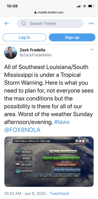
Timeline of when we can begin expecting conditions to worsen in SELA

Posted on 6/6/20 at 10:50 am to TDsngumbo
How much do we trust the euro wind output? This is gusts, not sustained, but I'm kind of surprised it's this high for Sunday at 1pm.


Posted on 6/6/20 at 10:51 am to TDsngumbo
quote:You should clear your browser history.
He's definitely trying to wrap some convection around his center this morning but there's still dry air being sucked into the circulation. So far, though, he's doing a very good job of fighting it off in my opinion.
Sounds like the plot of porno.

 Page 57 of 107

Popular
Back to top