- My Forums
- Tiger Rant
- LSU Recruiting
- SEC Rant
- Saints Talk
- Pelicans Talk
- More Sports Board
- Fantasy Sports
- Golf Board
- Soccer Board
- O-T Lounge
- Tech Board
- Home/Garden Board
- Outdoor Board
- Health/Fitness Board
- Movie/TV Board
- Book Board
- Music Board
- Political Talk
- Money Talk
- Fark Board
- Gaming Board
- Travel Board
- Food/Drink Board
- Ticket Exchange
- TD Help Board
Customize My Forums- View All Forums
- Show Left Links
- Topic Sort Options
- Trending Topics
- Recent Topics
- Active Topics
Started By
Message
re: Storm Update:- Ida Moves Away - The Cleanup Begins...
Posted on 8/28/21 at 4:39 pm to LegendInMyMind
Posted on 8/28/21 at 4:39 pm to LegendInMyMind
On the bright side, Sillin's plotting almost makes it look like Ida has a hankering for Miss Issippi.
I for one will not judge her for her preference...it is 2021 after all.
I for one will not judge her for her preference...it is 2021 after all.
Posted on 8/28/21 at 4:39 pm to toosleaux
Does he have reasoning or is he just randomly speculating
Posted on 8/28/21 at 4:39 pm to LegendInMyMind
Yikes, nam is overshooting wpc totals...

And I posted these earlier, but I don't think they've been updated:
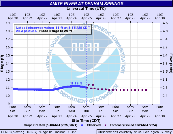
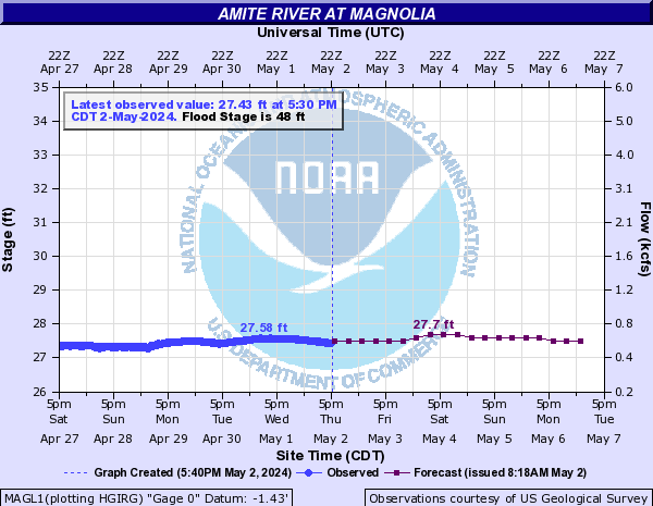
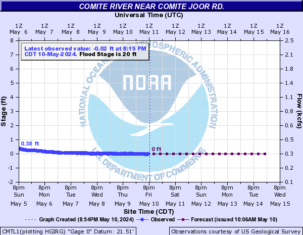
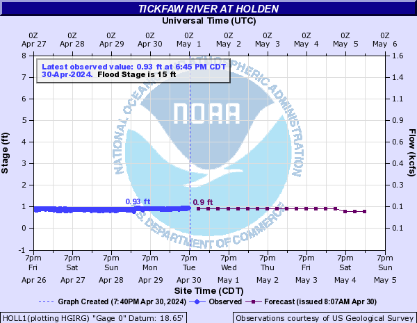

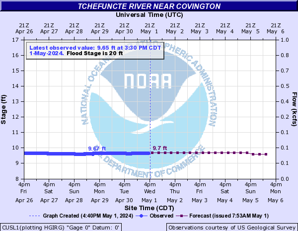

And I posted these earlier, but I don't think they've been updated:


Posted on 8/28/21 at 4:39 pm to Pedro
quote:
this is some shite I’d expect a drunk leppert to put on a PowerPoint
"Any questions or comments about this?"
Posted on 8/28/21 at 4:40 pm to Nguyener
NWS seems to think ALL of SE LA is gonna get fricked.
quote:
@NWSNewOrleans
There is some confusion surrounding the impacts that will occur across our area. Here is a breakdown of all the impacts we are expecting from Hurricane #Ida below by area/region. #Ida is a dangerous hurricane and it WILL produce LIFE-THREATENING impacts. #mswx #lawx
For the Baton Rouge metro area: Expect winds >110mph sustained. Rainfall 10-15” with 20”+ possible. Brief tornadoes possible. #lawx
For the River Parishes: Expect winds >110mph sustained. Rainfall 10-15” with 20”+ possible. Brief tornadoes possible. 5-8 ft of inundation in Lake Pontchartrain. #lawx
For Northshore: Expect winds >110mph sustained. Rainfall 15-20” with 20”+ possible. Brief tornadoes possible. 5-8ft of inundation in Lake Pontchartrain. #lawx
For metro NOLA: Expect winds >110mph sustained. Rainfall 15-20” with 20”+ possible. Brief tornadoes possible.
For the Coastal LA: Expect winds >110mph sustained. Rainfall 10-15” with 20”+ possible. Brief tornadoes possible. 10-15ft of inundation.
For SW MS: Expect winds >74mph sustained. Rainfall 8-12” with locally higher possible. Brief tornadoes possible.#mswx
For coastal MS: Expect winds >74mph sustained. Rainfall 8-12” with locally higher possible. Brief tornadoes possible. 7-11ft of inundation. 4-7ft inundation ocean springs to AL/MS line. #mswx
Conditions will begin to deteriorate TONIGHT! All preparations need to be completed by then. If you are under ANY evacuation order, PLEASE LEAVE! Your LIFE is worth more than your property. Stay safe! #mswx #lawx
This post was edited on 8/28/21 at 4:41 pm
Posted on 8/28/21 at 4:40 pm to MississippiLSUfan
This is my first hurricane thread I’ve actually followed (and has really affected me). Gentlemen it has been an honor.
Posted on 8/28/21 at 4:40 pm to LSUJuice
quote:
LSUJuice
Thank You for flooding related posting.
This is going to be a big part of the story I'm afraid.
Posted on 8/28/21 at 4:40 pm to LegendInMyMind
quote:
It is the NHC cone overlayed Jack Sillin's "Wobble Plot". He uses the satellite center fix to track the wobbles. He did pretty well with it on Laura last year.
I see what it is. I just can't look at it for more than 2 seconds without blacking out
Posted on 8/28/21 at 4:40 pm to Nguyener
From watching zoom.earth for the past hour, it’s definitely tracking more northerly now.
Not good for New Orleans.
Not good for New Orleans.
Posted on 8/28/21 at 4:41 pm to The Boat
Levi just spoke in tongues on Twitter.
Posted on 8/28/21 at 4:41 pm to Cuz413
quote:
The discussion is moving the landing closer to Port Fourchon due to the Northward jog.
 [quote]
Posted on 8/28/21 at 4:41 pm to bhtigerfan
So what's the chance this bitch keeps slipping east?
Posted on 8/28/21 at 4:41 pm to sp22
quote:
Does he have reasoning or is he just randomly speculating
trying to up the hype for nola
Posted on 8/28/21 at 4:41 pm to Bayou_Tiger_225
quote:
it's clearly showing a different path than every other model, and the NHC.
I’m not saying that guy is accurate, but the NHC tends to update slower and less drastically by design. It’s not a bad thing but it doesn’t respond to quick shifts.
It’s not a bad idea to watch both.
Posted on 8/28/21 at 4:42 pm to GREENHEAD22
It all depends on the High Presure System. Anybody know when that will come into play?
Posted on 8/28/21 at 4:42 pm to jlovel7
quote:
This is my first hurricane thread I’ve actually followed (and has really affected me). Gentlemen it has been an honor.
I do way more reading than posting, but have been following these for years. There’s really nothing like it. Welcome
Posted on 8/28/21 at 4:42 pm to Elleshoe
Any predictions for northshore north of 12?
Posted on 8/28/21 at 4:44 pm to Swagga
Looks like Ida is following the track direction, just slightly on the right side of it.
Posted on 8/28/21 at 4:45 pm to GEAUXmedic
quote:
For the Baton Rouge metro area: Expect winds >110mph sustained. Rainfall 10-15” with 20”+ possible. Brief tornadoes possible. #lawx
quote:
For metro NOLA: Expect winds >110mph sustained. Rainfall 15-20” with 20”+ possible. Brief tornadoes possible
well then
Popular
Back to top


 0
0


