- My Forums
- Tiger Rant
- LSU Recruiting
- SEC Rant
- Saints Talk
- Pelicans Talk
- More Sports Board
- Fantasy Sports
- Golf Board
- Soccer Board
- O-T Lounge
- Tech Board
- Home/Garden Board
- Outdoor Board
- Health/Fitness Board
- Movie/TV Board
- Book Board
- Music Board
- Political Talk
- Money Talk
- Fark Board
- Gaming Board
- Travel Board
- Food/Drink Board
- Ticket Exchange
- TD Help Board
Customize My Forums- View All Forums
- Show Left Links
- Topic Sort Options
- Trending Topics
- Recent Topics
- Active Topics
Started By
Message
re: Southeast Severe Weather Threat: March 4-5, 2025
Posted on 3/4/25 at 10:16 am to Roll Tide Ravens

Posted on 3/4/25 at 10:16 am to Roll Tide Ravens
Well...frick.
quote:
Here is the significant tornado parameter from the HRRR valid at 4:00 PM CST this afternoon.
 0
0


Posted on 3/4/25 at 10:20 am to Roll Tide Ravens
Getting good wind out here at the ol trailer house
Posted on 3/4/25 at 10:21 am to Odysseus32
What direction is wind expected to come out of in the Gonzales area?
This post was edited on 3/4/25 at 10:22 am

Posted on 3/4/25 at 10:22 am to Tiger328
quote:
What direction is wind expected to come out of?
Important info for the baseball game tonight.
Posted on 3/4/25 at 10:22 am to MorbidTheClown
That too, but East/West winds are not a good combo for my DIY gate I build for my fence!

Posted on 3/4/25 at 10:25 am to Tiger328
Wind is picking up in Metairie...

Posted on 3/4/25 at 10:26 am to Tiger328
quote:
What direction is wind expected to come out of in the Gonzales area?
SSE then dude south ahead of the line. SW behind the line

Posted on 3/4/25 at 10:27 am to Roll Tide Ravens


Posted on 3/4/25 at 10:28 am to Capt ST
Decently significant wind and/or suspected tornado damage in the upper burbs of Dallas. Moved through really fast to cause the damage we saw this am.
Posted on 3/4/25 at 10:41 am to Roll Tide Ravens
Clear velo hook on the south end of toledo bend heading toward Hornbeck
Posted on 3/4/25 at 10:43 am to TDsngumbo
quote:
That's the most I've seen posted for our area in a while. Is the thinking still that the biggest threat will be from discrete storms or are they thinking more of a solid line?
Sigtor is kind of a shite product. Watch along the gradient more than within the high values themselves. Central La, Ms line to Jackson
Posted on 3/4/25 at 10:44 am to The Boat
I think we just got the worst of what we’re going to get in N central LA.
Wind was nuts. It was swinging the big pine trees around like they were flaccid.
Wind was nuts. It was swinging the big pine trees around like they were flaccid.
Posted on 3/4/25 at 10:45 am to Roll Tide Ravens
Winds of 28 gusting to 40 at MSY.
Posted on 3/4/25 at 11:27 am to NorthEndZone
Fort Polk just got whacked

Posted on 3/4/25 at 11:28 am to The Boat
Stone cold beer gif
Posted on 3/4/25 at 11:30 am to S
Looks like a tornado went through
Posted on 3/4/25 at 11:33 am to 9Fiddy
quote:
It was swinging the big pine trees around like they were flaccid.
I've got a gif I could post but yall don't want to see it. tbh, I don't want to see it either.
Posted on 3/4/25 at 11:52 am to NorthEndZone
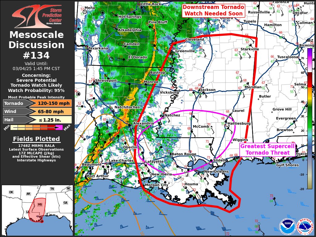
Mesoscale Discussion 0134
NWS Storm Prediction Center Norman OK
1149 AM CST Tue Mar 04 2025
Areas affected...Mississippi and eastern Louisiana
Concerning...Severe potential...Tornado Watch likely
Valid 041749Z - 041945Z
Probability of Watch Issuance...95 percent
SUMMARY...A downstream tornado watch will be needed soon.
DISCUSSION...Low to mid 60s dewpoints have started to surge inland
across southeast Louisiana over the past 2 hours. Sustained 15 to 25
knot southeasterly flow ahead of the squall line should lead to
rapid northward destabilization across Mississippi during the next
few hours. This squall line is currently producing severe wind gusts
with a 61 knot wind gust at KPOE at 1727 UTC. Mid 60s dewpoints are
expected south of I-20 in Mississippi which should correspond to the
area of greatest instability and tornado threat this afternoon.
North of I-20, upper 50s to low 60s dewpoints should result in
sufficient instability for a severe wind threat and perhaps some
line-embedded tornadoes given the magnitude of the low-level shear.
Across eastern Louisiana and southern Mississippi, where better
low-level moisture will be present and some heating may result in
greater instability, discrete supercells may be possible. This is a
scenario supported by the HRRR consistently. Even if mature
supercells do not develop ahead of the main squall line, the weaker
forced southern end of the squall line will likely result in a less
defined line with embedded supercells. Any supercells which develop,
ahead of or within the line, will pose a threat for strong tornadoes
given RAP forecast STP values around 3 to 4 this afternoon and
evening. Additionally, the strong kinematic environment will support
QLCS tornadoes within the better defined squall line.
A tornado watch will be issued soon to address the threat from the
squall line and any supercells which may develop ahead of the line.
This post was edited on 3/4/25 at 11:57 am
Posted on 3/4/25 at 12:02 pm to Roll Tide Ravens
Definitely concerning in the HRRR for that circled purple area
Discrete in the purple area, linear farther north
Discrete in the purple area, linear farther north

Posted on 3/4/25 at 12:03 pm to DVinBR
When is the worst of it supposed to come through Baton Rouge?

 Page 4 of 9

Popular
Back to top