- My Forums
- Tiger Rant
- LSU Recruiting
- SEC Rant
- Saints Talk
- Pelicans Talk
- More Sports Board
- Fantasy Sports
- Golf Board
- Soccer Board
- O-T Lounge
- Tech Board
- Home/Garden Board
- Outdoor Board
- Health/Fitness Board
- Movie/TV Board
- Book Board
- Music Board
- Political Talk
- Money Talk
- Fark Board
- Gaming Board
- Travel Board
- Food/Drink Board
- Ticket Exchange
- TD Help Board
Customize My Forums- View All Forums
- Show Left Links
- Topic Sort Options
- Trending Topics
- Recent Topics
- Active Topics
Started By
Message
re: Severe weather threat tomorrow
Posted on 10/11/22 at 3:54 pm to winkchance
Posted on 10/11/22 at 3:54 pm to winkchance
quote:
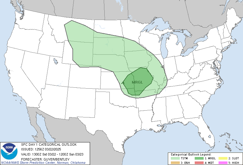
Marginal = Severe?
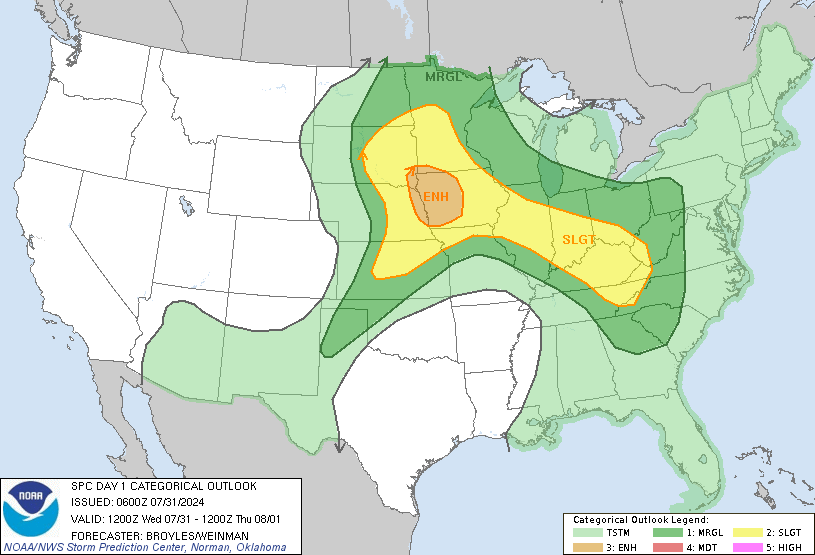
The Eastern Kentucky area may see a bump to Slight in the morning. There's a decent enough chance some of the cells prior to the front could cause problems. Those storms this time of year are the ones that catch people off guard. There's a narrow corridor where what favorable conditions are present could come together to be a problem.
I imagine it is enough for Ryan Hall to throw up a scary graphic to grab some attention.
This post was edited on 10/11/22 at 3:59 pm
Posted on 10/11/22 at 3:55 pm to Chad504boy
quote:
that'sagreenpenisgif:
Perhaps if we’re talking about a serious case of peyronie’s disease.
Posted on 10/11/22 at 3:56 pm to tigerinthebueche
quote:
motherfricker, I had plenty from July through the first week of September. frick off with the "we need rain" bullshite.
Technically, you do need rain. You're probably pushing ten inches below normal for the year at this point.
Posted on 10/11/22 at 4:23 pm to The Boat
quote:
SMH at rds starting a thread for the shitter that went straight into Central America but not for the shitter invest that's actually in the Gulf.
We have a named storm in the gulf and I found out about from somewhere other than TD.
What is this world coming to.
Posted on 10/11/22 at 4:28 pm to fightin tigers
North Gulf closed baw. Its cold front season.
This post was edited on 10/11/22 at 4:29 pm
Posted on 10/11/22 at 4:38 pm to fightin tigers
quote:
We have a named storm in the gulf and I found out about from somewhere other than TD.
What is this world coming to.
There's a reason, and that reason is this:

Even the NHC is struggling to take that windfield graphic seriously.
Posted on 10/11/22 at 4:40 pm to LegendInMyMind
quote:
The Eastern Kentucky area may see a bump to Slight in the morning. There's a decent enough chance some of the cells prior to the front could cause problems. Those storms this time of year are the ones that catch people off guard.
And to think you chastised me for making the thread
I’m just looking out for my fellow man
Posted on 10/11/22 at 4:49 pm to deltaland
quote:
And to think you chastised me for making the thread
There's still no yellow on the outlook, baw. This thread is anarchy, and I'm to blame for posting in it.
Posted on 10/11/22 at 4:55 pm to Cosmo
quote:
Hurricane season is over for the northern gulf, stronger and stronger cold fronts pushing through weekly for the next month
Michael made landfall 3 years ago yesterday.
I definitely prefer my storms to be land fueled.
Water fueled storms can get really nasty.
Posted on 10/11/22 at 4:58 pm to LegendInMyMind
Ryan Hall will throw up a scary graphic for a warm (or cold) breeze.
Posted on 10/11/22 at 6:41 pm to LegendInMyMind
It’s coming I can feel it. I’m just ahead of the curve
Posted on 10/11/22 at 7:57 pm to Cosmo
Yep Karl was the last ditch hope for the northern Gulf; but wind shear is too strong to his North.
Low's in the upper 40's mid next week should shut down Tropical Storm season too
Low's in the upper 40's mid next week should shut down Tropical Storm season too
Posted on 10/11/22 at 8:09 pm to deltaland
So nowadays, we call thunderstorm forecasts “slight, marginal or enhanced severe weather”.
And in the map above, about a third of the country will be under a “marginal severe weather alert”, which means “it’s gonna rain y’all”.
And in the map above, about a third of the country will be under a “marginal severe weather alert”, which means “it’s gonna rain y’all”.
Posted on 10/12/22 at 8:01 am to lz2112
quote:
quote:
Hurricane season is over for the northern gulf, stronger and stronger cold fronts pushing through weekly for the next month
Michael made landfall 3 years ago yesterday.
I definitely prefer my storms to be land fueled.
Water fueled storms can get really nasty.
Michael was a monster, but also Hurricane Zeta was much later, friggin October 28th landfall as a Cat 3 I think. It's never over till it's over, seems you can't relax till couple weeks into Nov these days.
Posted on 10/12/22 at 8:14 am to deltaland
Slight risk expanded

May actually get a narrow corridor of ENH depending on how conditions evolve this morning
Mid-South to Lower MS and TN Valleys...
A band of thunderstorms is ongoing across parts of the Ozark
Plateau, just ahead of a surface cold front. Bulk of CAM guidance
suggests this leading activity will persist to the east-southeast
through the day towards the Mid-South portion of the MS Valley,
likely aided by low-level warm theta-e advection from the southern
Great Plains atop an initially dry boundary layer over AR.
Pronounced boundary-layer heating across the Lower MS Valley should
yield intensification of the band towards early afternoon with
potential for a QLCS to evolve into the TN Valley later. The
initially bifurcated low-level moisture plume suggests that
relatively large surface temperature/dew point spreads would favor
scattered damaging winds as the primary severe threat during the
afternoon.
A second round of severe thunderstorm development is anticipated
towards late afternoon near the intersection of trailing outflow
from the lead activity with the lagging cold front, as it impinges
on a moderately buoyant air mass over the Lower MS Valley where
MLCAPE should reach 1500-2000 J/kg. Despite initially veered and
modest low-level flow, remnants of the Great Plains elevated mixed
layer in conjunction with adequate deep-layer speed shear will favor
semi-discrete storms, including a few supercells. Large hail will be
most likely in the first few hours of development before convection
tends to consolidate into additional southeast-moving line segments
this evening, with a primary threat of damaging winds and a couple
brief tornadoes.
...OH/KY...
The eastern fork of the bifurcated low-level moisture plume
emanating from the Gulf is expected to advect north across
central/eastern KY to southern OH. Pre-frontal thunderstorm activity
ongoing across the Mid-MS Valley will likely persist east and may
intensify as it impinges on this eastern moisture plume. Confidence
is low with respect to the degree of destabilization into this
portion of the OH Valley given the abundant upstream
precipitation/cloud cover. Should a confined corridor of weak to
modest MLCAPE occur later this afternoon, adequate low-level
hodograph curvature will exist for a supercell or two capable of a
brief tornado and locally damaging winds.
Posted on 10/12/22 at 11:53 am to deltaland
Thread is shite. Looks to be dry as your gmaws pussy today
Posted on 10/12/22 at 12:01 pm to tunechi
quote:
Thread is shite. Looks to be dry as your gmaws pussy today
You understand that the world extends beyond your front yard, right?
Popular
Back to top


 2
2


