- My Forums
- Tiger Rant
- LSU Recruiting
- SEC Rant
- Saints Talk
- Pelicans Talk
- More Sports Board
- Fantasy Sports
- Golf Board
- Soccer Board
- O-T Lounge
- Tech Board
- Home/Garden Board
- Outdoor Board
- Health/Fitness Board
- Movie/TV Board
- Book Board
- Music Board
- Political Talk
- Money Talk
- Fark Board
- Gaming Board
- Travel Board
- Food/Drink Board
- Ticket Exchange
- TD Help Board
Customize My Forums- View All Forums
- Show Left Links
- Topic Sort Options
- Trending Topics
- Recent Topics
- Active Topics
Started By
Message
re: Severe weather threat continues today for parts of the southeast - Threat is Over.
Posted on 3/17/21 at 1:25 pm to LegendInMyMind
Posted on 3/17/21 at 1:25 pm to LegendInMyMind
 1
1


Posted on 3/17/21 at 1:25 pm to rds dc
quote:
Conditions look to become more favorable for tornadoes
What area are you referencing?
Nevermind, I see your edit now. Do you think south Louisiana will actually get any significant severe weather? I'm just so numb to it after the last, what - 8-10 times, where it was hyped up big time for us and it was a huge bust for the most part.
This post was edited on 3/17/21 at 1:30 pm
Posted on 3/17/21 at 1:27 pm to TDsngumbo
quote:
What area are you referencing?
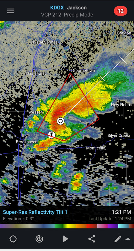
Looks to be the PDS warning over western MS.

Posted on 3/17/21 at 1:27 pm to The Boat
quote:
Debris ball
Since I moved from Oklahoma City to New Orleans 13 years ago, I’ve been out of the severe weather game. In the hours and hours I spent watching weather coverage in my 22 years in OK, I don’t recall hearing Gary England talk about “debris balls” in radar imagery. Is this something new?
Posted on 3/17/21 at 1:28 pm to TDsngumbo
Probabaly those cells near lake Charles as they lift off to the northeast later this afternoon
Posted on 3/17/21 at 1:28 pm to TDsngumbo
quote:
quote:
Conditions look to become more favorable for tornadoes
What area are you referencing?
Mostly that internet is hard for me
Here is what I was trying to post:
Over the next few hours cnditions look to become more favorable for tornadoes across S. LA. I would expect a new watch in not too long.
Posted on 3/17/21 at 1:29 pm to LegendInMyMind
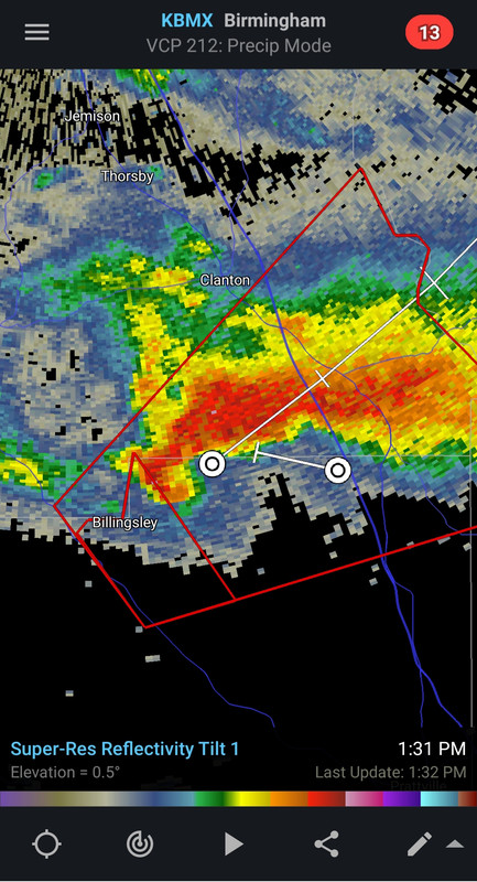
The Selma storm is so far the long-track storm of the day. Still a good chance it is on the ground.

Posted on 3/17/21 at 1:29 pm to theOG
quote:
Since I moved from Oklahoma City to New Orleans 13 years ago, I’ve been out of the severe weather game. In the hours and hours I spent watching weather coverage in my 22 years in OK, I don’t recall hearing Gary England talk about “debris balls” in radar imagery. Is this something new?
Dat dual pol correlation coefficient shows you the uniformity or non uniformity of what the radar beams are bouncing off of. If you have houses and trees and boards and cars and children flying through the air where the tornado is you get what looks like a black hole where the non uniformity is.
Posted on 3/17/21 at 1:30 pm to rds dc
quote:
Mostly that internet is hard for me
Here is what I was trying to post:
Over the next few hours cnditions look to become more favorable for tornadoes across S. LA. I would expect a new watch in not too long.
You zigged when you meant to zag on that one and got me.

Posted on 3/17/21 at 1:31 pm to LegendInMyMind
It seems like these Alabama tornadoes so often hit the same areas. Places like Oak Grove, Cullman, Carbon Hill, etc. seem to always be in the mix.
Posted on 3/17/21 at 1:31 pm to The Boat
quote:
If you have houses and trees and boards and cars and children flying through the air where the tornado is you get what looks like a black hole where the non uniformity is.
I'm a father of two beautiful and perfect children and I literally tear up at the thought of how much I love them, but this made me laugh out loud.
Posted on 3/17/21 at 1:31 pm to The Boat
quote:
If you have houses and trees and boards and cars and children flying through the air where
Posted on 3/17/21 at 1:32 pm to TideCPA
quote:
It seems like these Alabama tornadoes so often hit the same areas. Places like Oak Grove, Cullman, Carbon Hill, etc. seem to always be in the mix.
Tanner, East Limestone, Harvest....
It is a classic path.

Posted on 3/17/21 at 1:32 pm to TDsngumbo
quote:
Why is Brookhaven to Hattiesburg such a magnet to tornados? Seems that general area gets one or two significant tornados every year or two.
I swear there almost has to be some sort of geographic component to this, because we hear the exact same small community names mentioned in Mississippi and Alabama almost every time.
Posted on 3/17/21 at 1:33 pm to LegendInMyMind

Posted on 3/17/21 at 1:33 pm to LegendInMyMind
quote:
If you have houses and trees and boards and cars and children flying through the air where
quote:

This post was edited on 3/17/21 at 1:34 pm
Posted on 3/17/21 at 1:34 pm to theOG
quote:
22 years in OK, I don’t recall hearing Gary England talk about “debris balls” in radar imagery. Is this something new?
No it’s just nothing in Oklahoma to make debris
Posted on 3/17/21 at 1:35 pm to lsuman25
The Lake Charles area WOULD be the first in Louisiana to receive bad weather out of this.
Posted on 3/17/21 at 1:35 pm to LegendInMyMind
Still has a defined hook. That random westward storm path is weird, though.

Posted on 3/17/21 at 1:35 pm to paperwasp
quote:
some sort of geographic component to this
trailer parks?

 Page 35 of 64

Popular
Back to top