- My Forums
- Tiger Rant
- LSU Recruiting
- SEC Rant
- Saints Talk
- Pelicans Talk
- More Sports Board
- Coaching Changes
- Fantasy Sports
- Golf Board
- Soccer Board
- O-T Lounge
- Tech Board
- Home/Garden Board
- Outdoor Board
- Health/Fitness Board
- Movie/TV Board
- Book Board
- Music Board
- Political Talk
- Money Talk
- Fark Board
- Gaming Board
- Travel Board
- Food/Drink Board
- Ticket Exchange
- TD Help Board
Customize My Forums- View All Forums
- Show Left Links
- Topic Sort Options
- Trending Topics
- Recent Topics
- Active Topics
Started By
Message
re: Severe weather threat continues today for parts of the southeast - Threat is Over.
Posted on 3/17/21 at 8:33 am to Impotent Waffle

Posted on 3/17/21 at 8:33 am to Impotent Waffle
quote:
What are we expecting in BR this afternoon?
panic and confusion on the part of the safety guy.
 0
0

Posted on 3/17/21 at 8:36 am to lsuman25

Posted on 3/17/21 at 8:39 am to CaptSpaulding
Is everybody really freaking out about this little line of storms over Texas right now? Looks like it will last 5 minutes and be over

Posted on 3/17/21 at 8:41 am to Fox McCloud
quote:
Is everybody really freaking out about this little line of storms over Texas right now?
Nah, it's what's going to develop out in front of it in a few hours that's the problem I believe.
This post was edited on 3/17/21 at 8:42 am

Posted on 3/17/21 at 8:46 am to HogX
Pretty foggy and overcast here in west Georgia. Hopefully it hangs around and keeps the atmosphere from heating up too much. High today is only 69.
Posted on 3/17/21 at 8:47 am to Roll Tide Ravens
The "new" radar set up by the NWS sucks. Under the old system, you could click on a button and get the Shreveport or Ft. Polk radar. It was clear, and warnings were in boxes. The new system gives you two radar options: The Shreveport radar which highlights in mildly opaque yellow the warnings (but obscures and covers the radar data) or enlarge the national radar which inexplicably uses blue boxes (instead of the yellow everywhere else) for a severe thunderstorm warning.
The old system also had more location clues. You could really figure out what was coming your way.
The old system also had more location clues. You could really figure out what was coming your way.

Posted on 3/17/21 at 8:48 am to Fox McCloud
quote:
Is everybody really freaking out about this little line of storms over Texas right now? Looks like it will last 5 minutes and be over
No. In places like Mississippi and Alabama we will be having multiple rounds of severe weather. We will have discreet supercells well in advance of that line, which will have a threat of producing tornadoes. Then, that “little line” won’t be so little when it comes through here as a second round of severe weather for us later tonight. By then, that “little line” will be a broken line of semi-discreet supercells that will have a threat of producing tornadoes.
This post was edited on 3/17/21 at 8:49 am

Posted on 3/17/21 at 8:49 am to chinhoyang
Posted on 3/17/21 at 8:53 am to SM6
quote:Same here in north Gwinnett. WSB this morning was saying that the storms shouldn't show up in west metro area until 8 or so tonight.
Pretty foggy and overcast here in west Georgia
Posted on 3/17/21 at 8:53 am to PJinAtl

Posted on 3/17/21 at 8:54 am to Roll Tide Ravens
This sucker blew through DFW pretty good last night. Some pretty strong wind. Woke me up and I usually sleep through storms.
Posted on 3/17/21 at 9:05 am to McCaigBro69
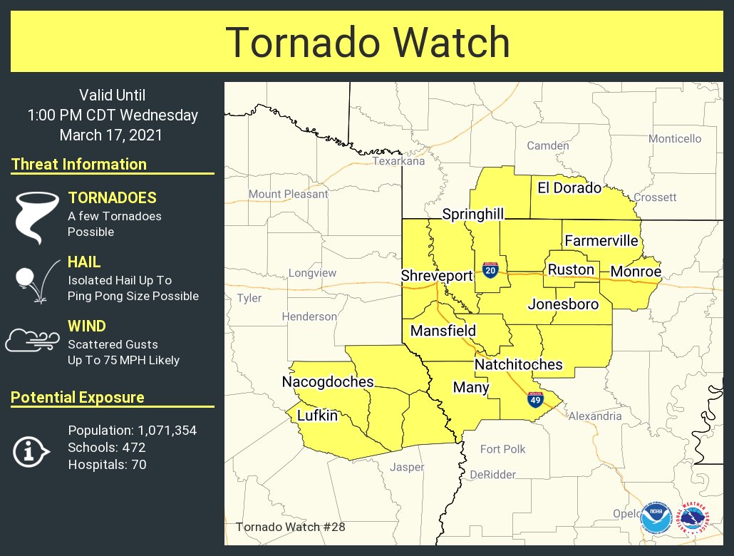
current conditions from the Monroe airport... which is in the high risk zone
73 degrees
Mostly Cloudy
humidity 81%
wind S @ 15 gusting to 30
73 degrees
Mostly Cloudy
humidity 81%
wind S @ 15 gusting to 30
This post was edited on 3/17/21 at 9:07 am
Posted on 3/17/21 at 9:05 am to McCaigBro69
Sun is starting to peak through the clouds in Lafayette. That's not what we want.
Posted on 3/17/21 at 9:06 am to purple18
Satellite imagery showing substantial clearing over central Mississippi. Not what we want to see.
Posted on 3/17/21 at 9:08 am to Roll Tide Ravens
quote:
Meteorologist Nick Mikulas
Sorry for the delay. Here you go. Looks like quite an active day.
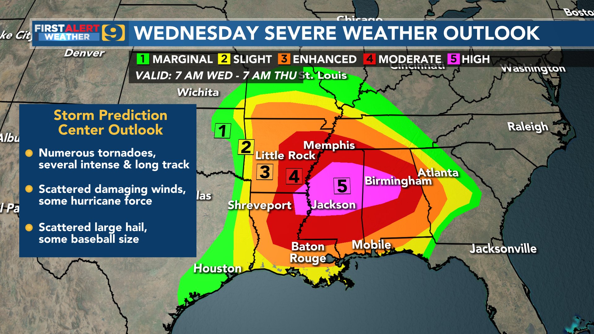
There have already been tornado warnings in North Mississippi, and Northeast Texas to start things off, and this is only just a little piece of the beginning. It looks like a 2 day outbreak of severe weather is underway. That outbreak will stretch from East Texas through most of the southeast as far north as Virginia, and as far south as Florida. Let me be clear that this is only a 1 day, and mainly a 6-8 hour window for us locally, but I think we will see several long track, damaging tornadoes across the southeastern 1/4 of the United States in the next two days, with a good potential we see some problems in our area. Here’s what I think will happen locally.
Radar is lighting up ahead of the main cold front in east Texas. Those storms have been consistently severe, and should remain strong to severe this morning, and early afternoon. The main issue will come as storms start to fire out ahead of that main line. That’s when they can become isolated supercells that have the potential to produce strong tornadoes, large hail in excess of 2 inches in diameter, and damaging wind in excess of 75 mph. Those threats will generally remain isolated, but it is likely that we see all of them somewhere in our area this afternoon. Again, the highest risk is to our northeast, but that basically means they will have a longer duration of a threat, not so much that the threat is for much more severity to the storms. It’s just that they may have to deal with a few rounds, and I think most of us see 1 round, maybe 2. Most of our area is under a moderate risk, or level 4 of 5 threat for severe weather. As the current SPC forecast breaks down, we have a 30% chance of damaging wind within 25 miles of a point, a 30% chance for hail greater than 1 inch in diameter within 25 miles of a point, and a 15% chance of tornadoes within 25 miles of a point. I know that’s a bit confusing, but that roughly equates to the chances of us seeing each of these events in a parish the size of Rapides. These are high end chances, even though the numbers may seem a bit low. In simplest terms, that means that SPC is saying there is a 1 in 6 chance that a tornado hits Rapides Parish today. There is also a 10% chance for significant severe weather, meaning tornadoes of EF2 or greater strength, hail greater than 2 inches in diameter, and wind in excess of 75 mph.
The good news, if you can call it that, is that this is happening during the day, so we will all be aware of what is happening. Don’t find yourself saying you had no idea today was going to be a busy weather day. Have multiple ways to get warnings, especially from around 12:00-8:00 PM. I think 1:00-5:00 is prime time in Rapides Parish, and that timing will be a bit earlier out west, and a bit later to the east. This could absolutely coincide with school pick up. Remember, your child is in a relatively safe place at school. Don’t get caught in a damaging storm trying to get to the pick up line. I would imagine they wouldn’t be letting them out if there are active warnings in place. At least I hope not! There may be a couple of inches of rain in stronger storms, but our main concern today will be severe weather. I will likely be on the road chasing after noon, so I’ll transition from general information, to following along behind the most suspect storm, or the one threatening the most people. It’s always tough to impossible to see tornadoes in Louisiana, so don’t try and see something if you have a tornado warning in your area. It’s why so few people chase here. It’s tough to see, and can be quite dangerous if you aren’t in the right position. I’ll update as things start to unfold.
Posted on 3/17/21 at 9:08 am to purple18
(no message)
This post was edited on 3/17/21 at 9:09 am
Posted on 3/17/21 at 9:09 am to Large Farva
quote:
Sun is starting to peak through the clouds in Lafayette. That's not what we want.
Why do you not want that?
Posted on 3/17/21 at 9:10 am to purple18
quote:
Sun is starting to peak through the clouds in Lafayette. That's not what we want.
Apparently public schools are getting out early. Is it really supposed to be that bad here?

Posted on 3/17/21 at 9:11 am to PJinAtl
quote:
WSB this morning was saying that the storms shouldn't show up in west metro area until 8 or so tonight.
Are they naming the storm “GameStop”? Acronyms are out of control.
Posted on 3/17/21 at 9:12 am to TDTOM
quote:
Brett Adair
@AlaStormTracker
Finally to all my chaser friends... Welcome to the Jungle.

 Page 21 of 64

Back to top