- My Forums
- Tiger Rant
- LSU Recruiting
- SEC Rant
- Saints Talk
- Pelicans Talk
- More Sports Board
- Fantasy Sports
- Golf Board
- Soccer Board
- O-T Lounge
- Tech Board
- Home/Garden Board
- Outdoor Board
- Health/Fitness Board
- Movie/TV Board
- Book Board
- Music Board
- Political Talk
- Money Talk
- Fark Board
- Gaming Board
- Travel Board
- Food/Drink Board
- Ticket Exchange
- TD Help Board
Customize My Forums- View All Forums
- Show Left Links
- Topic Sort Options
- Trending Topics
- Recent Topics
- Active Topics
Started By
Message
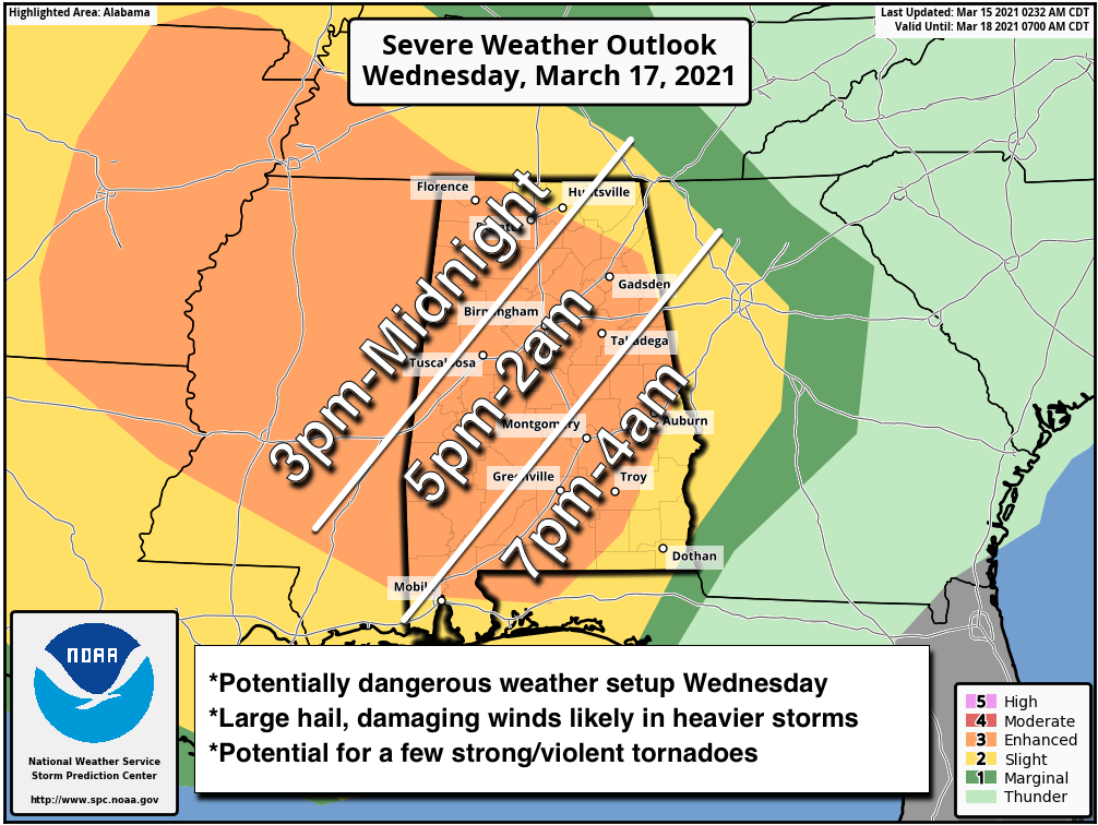
re: Severe weather threat continues today for parts of the southeast - Threat is Over.
Posted on 3/15/21 at 6:30 am to Roll Tide Ravens
Posted on 3/15/21 at 6:30 am to Roll Tide Ravens
Spann marked some timing forecasts for Alabama. Can assume you can extrapolate the times back into Mississippi.
 1
1


Posted on 3/15/21 at 6:32 am to Rebel
quote:
I’m in the 30% zone.
Does that also mean there is a 70% chance there won’t be severe weather?
Not really, it means there is a good chance of severe storms in that area. A 30% risk is a significant risk.
I get that 30% seems low, but again, it is significant. Even high risk days are usually 45%.
This post was edited on 3/15/21 at 6:49 am
Posted on 3/15/21 at 7:01 am to Roll Tide Ravens
I thought the 30% was something along the lines of reasoning that there is a 30% chance of a severe weather event, thunderstorm or tornado, that will occur within so many miles of any particular location.
It's much different terminology than a rain forecast of, say 30% chance of rain.
It's much different terminology than a rain forecast of, say 30% chance of rain.
Posted on 3/15/21 at 7:09 am to East Coast Band
quote:
thought the 30% was something along the lines of reasoning that there is a 30% chance of a severe weather event, thunderstorm or tornado, that will occur within so many miles of any particular location.
That’s exactly right. It means there is a 30% of severe weather within 25 miles of a given point in that area.
This post was edited on 3/15/21 at 7:10 am
Posted on 3/15/21 at 8:20 am to Roll Tide Ravens
I’ve seen discussion from multiple meteorologists about the possibility of a few long-track, strong/violent tornadoes with this event. Certainly concerning.

Posted on 3/15/21 at 8:31 am to Roll Tide Ravens
I've been in west central Georgia for a few years now and always follow severe weather events in the area. It seems like without fail, they largely dissipate by the time they reach the Georgia/Alabama border. I know Georgia will occasionally get hit, but it seems like Alabama always gets slammed then it quickly calms down.
Is there some reason for that, or am I just imagining things?
Is there some reason for that, or am I just imagining things?
Posted on 3/15/21 at 8:44 am to Roll Tide Ravens
Forecasts linked below show the worse weather for Tennessee coming on Thursday. LINK

Posted on 3/15/21 at 8:53 am to LegendInMyMind
quote:
It is like the OT, but for storms.
Posted on 3/15/21 at 9:10 am to SM6
Well, yesterday was the anniversary of the tornado that struck the Georgia Dome while the SEC tournament was going on.
But to answer your question, I'll guess it has something to do with the Appalachian mountains that causes fewer tornadoes. Or possibly that the Gulf of Mexico, which provides a lot of the instability, isn't directly south of most of Georgia.
But to answer your question, I'll guess it has something to do with the Appalachian mountains that causes fewer tornadoes. Or possibly that the Gulf of Mexico, which provides a lot of the instability, isn't directly south of most of Georgia.
Posted on 3/15/21 at 9:20 am to SM6
quote:
Is there some reason for that, or am I just imagining things?
It’s probably a combination of different things. I don’t have the meteorological knowledge to really explain it, but I can list a few factors that probably contribute. As storms enter Georgia in these events, the better dynamic support from the low pressure system is likely pulling away many times, so the ingredients for severe storms/tornadoes start to lessen (wind shear, helicity, etc.). A lot of these events occur when it is after dark, so when the storms enter Georgia it has often been dark for several hours so there is less heating from the daytime to coincide with the storms, which can mean less instability for the storms to work with. Another thing that sometimes comes into play is a wedge of cooler air coming down the Appalachians.
This post was edited on 3/15/21 at 9:24 am
Posted on 3/15/21 at 9:24 am to Roll Tide Ravens
quote:
Roll Tide Ravens
That makes sense, appreciate the answer. We always keep an eye on it, but have been fortunate so far. When the big storms came through on March 19, 2018 one small twister ripped up the GDOT storage shed on I-85 not too far from us, but all of the serious storms were in Alabama.
Posted on 3/15/21 at 11:04 am to Roll Tide Ravens
quote:
I’ve seen discussion from multiple meteorologists about the possibility of a few long-track, strong/violent tornadoes with this event. Certainly concerning.
I have tried and tried to find the historical analog model like the others I posted, but for potential for long track tornadoes, instead. I saw it posted once on Twitter, but can't find the source. I'd like to see it if I could find it.
Posted on 3/15/21 at 11:08 am to East Coast Band
quote:
Do we have any new terms that the SPC have added this year?
The only thing they changed were the Advisories. I think they pretty much did away with them, and will use similar guidance in the discussions and outlooks instead of cluttering the warning process with all the different advisories.
Posted on 3/15/21 at 11:15 am to LegendInMyMind
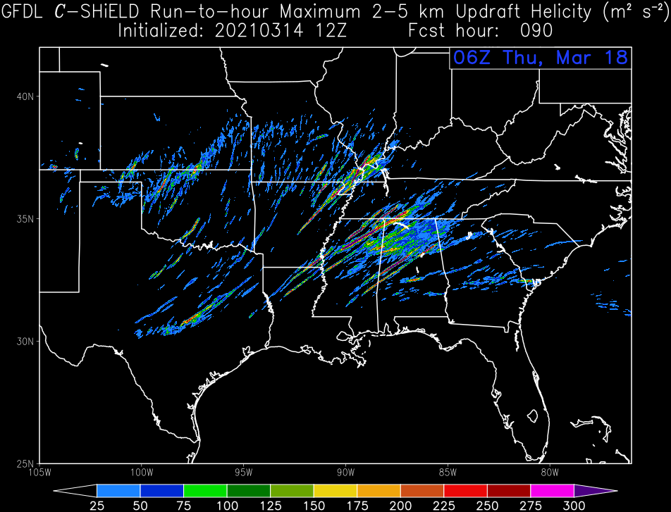
Pretty good helicity signatures showing up. This is cumulative for 90 hours out from 12z today. It is pretty much right where you'd expect it to be.
Posted on 3/15/21 at 11:25 am to East Coast Band
quote:
But to answer your question, I'll guess it has something to do with the Appalachian mountains that causes fewer tornadoes. Or possibly that the Gulf of Mexico, which provides a lot of the instability, isn't directly south of most of Georgia.
It really is weird how localized geography can affect a given storm, or system. Like you said, it can impact negatively and serve to decrease tornado development. Or, it can be the exact opposite. There is pretty good research into this going on right now in the Sand Mountain area of Northeast Alabama. Usually, storms seem to weaken as the move across the state, but often restrengthen when approaching the mountainous terrain. They still don't completely understand why, but they know it has to do with the microclimate that exists in the area.
Posted on 3/15/21 at 11:39 am to LegendInMyMind

I'm no weather expert but it seems like this stretch of Southeastern states has really ramped up in activity to rival or even surpass Tornado alley as the more notorious tornado belt. Seems like from somewhere around Alexandria in Louisiana and ramping up in the more intense storms into Central Mississippi and Northern Alabama.
Posted on 3/15/21 at 11:48 am to Lsuhoohoo
quote:
I'm no weather expert but it seems like this stretch of Southeastern states has really ramped up in activity to rival or even surpass Tornado alley
That's why they call it "Dixie Alley", which I'm surprised hasn't been canceled yet. I wouldn't say that it has ramped up, necessarily. The area has always had more than it's fair share of tornadoes. What sets it apart from Tornado Alley is population density. There are so many medium and larger cities and towns that aren't separated by that much real estate. When you have a long track tornado out west, it can go for 20 miles and never cross paths with a town. That's not the case in MS, AL, TN, etc.
Posted on 3/15/21 at 11:51 am to LegendInMyMind
James Spann
@spann
New output from the 3km NAM shows elevated STP (Significant Tornado Parameter) values across Alabama and Mississippi (valid at 7p CT)… severe storms are likely with potential for a few strong/violent tornadoes Wednesday afternoon and Wednesday night.
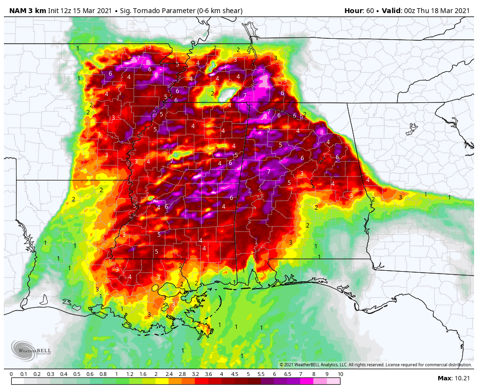
@spann
New output from the 3km NAM shows elevated STP (Significant Tornado Parameter) values across Alabama and Mississippi (valid at 7p CT)… severe storms are likely with potential for a few strong/violent tornadoes Wednesday afternoon and Wednesday night.
Posted on 3/15/21 at 11:57 am to weadjust
I assume those numbers embedded are not good for you if it's a "7"
Posted on 3/15/21 at 12:02 pm to weadjust
Low level jet has been trending stronger since last night, which is something that favors severe weather/tornadoes.

 Page 2 of 64

Popular
Back to top