- My Forums
- Tiger Rant
- LSU Recruiting
- SEC Rant
- Saints Talk
- Pelicans Talk
- More Sports Board
- Fantasy Sports
- Golf Board
- Soccer Board
- O-T Lounge
- Tech Board
- Home/Garden Board
- Outdoor Board
- Health/Fitness Board
- Movie/TV Board
- Book Board
- Music Board
- Political Talk
- Money Talk
- Fark Board
- Gaming Board
- Travel Board
- Food/Drink Board
- Ticket Exchange
- TD Help Board
Customize My Forums- View All Forums
- Show Left Links
- Topic Sort Options
- Trending Topics
- Recent Topics
- Active Topics
Started By
Message

 0
0

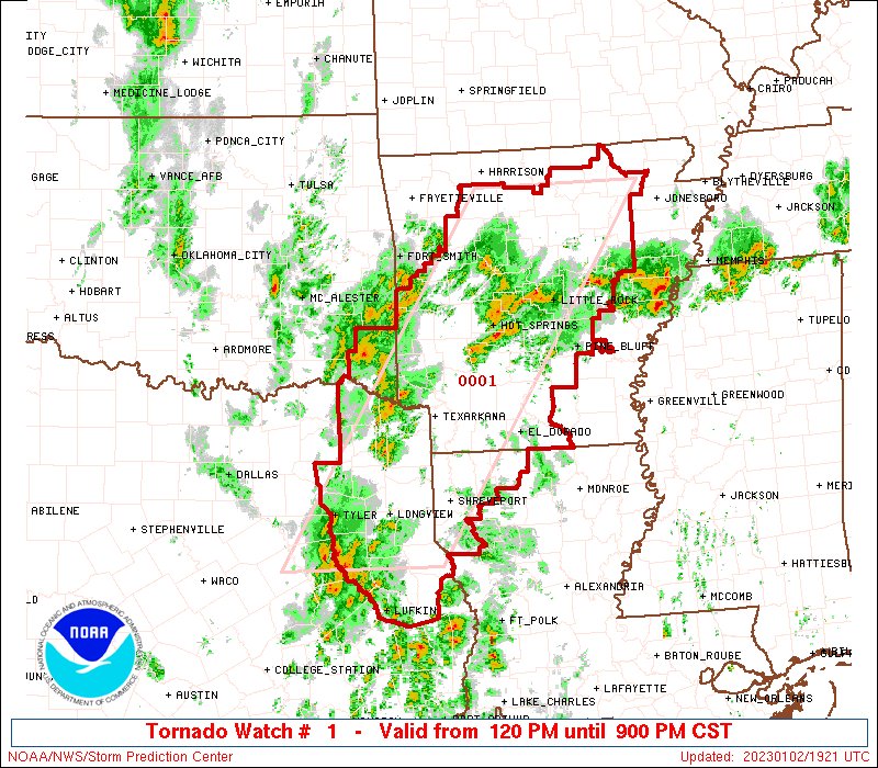
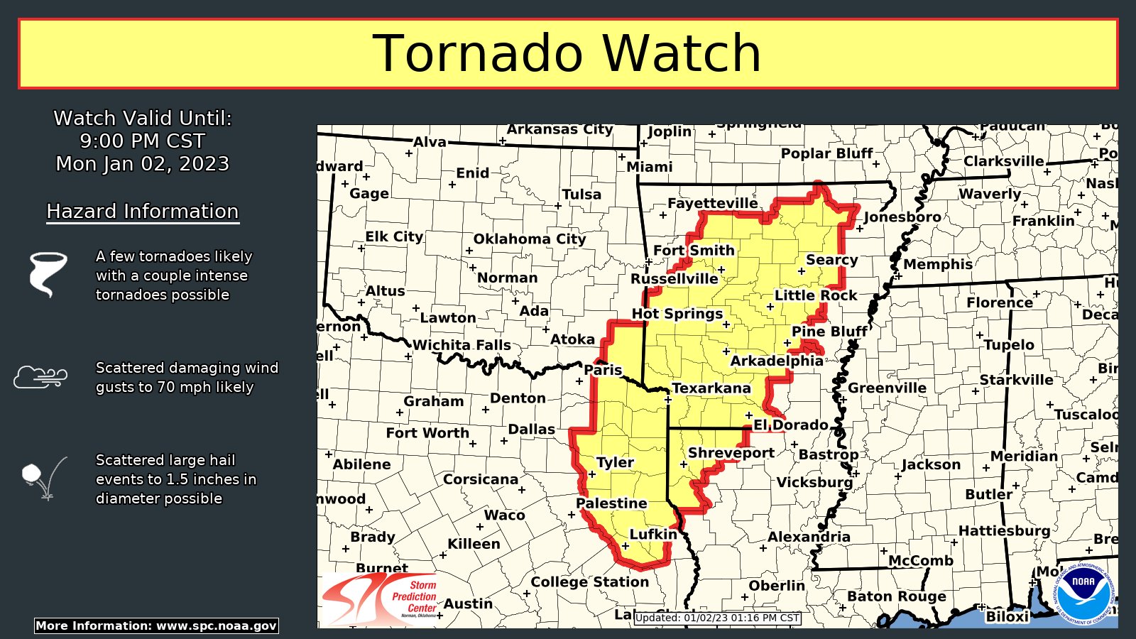
Posted on 1/2/23 at 1:18 pm to lachellie
quote:
Remind me again, is that good or bad? And thanks for your (all you mets) patience and service in these threads.
Higher CAPE is bad. Seeing the temps and dews rise like they have means storms have more instability and energy to work with. We've seen surface winds shift more out of the SSE throughout the day, and that's helped ramp up moisture across the at risk area. Shreveport is currently at 77°/66°, with similar readings across the open warm sector.

Posted on 1/2/23 at 1:28 pm to Bobby OG Johnson
Posted on 1/2/23 at 1:32 pm to LegendInMyMind
quote:
Higher CAPE is bad. Seeing the temps and dews rise like they have means storms have more instability and energy to work with. We've seen surface winds shift more out of the SSE throughout the day, and that's helped ramp up moisture across the at risk area. Shreveport is currently at 77°/66°, with similar readings across the open warm sector.
Thanks. I know at times it must seem like Severe Weather for Dummies on these threads but y’all’s experience and expertise is a big help. For me the CAPE/cap thing gets me every time.
Posted on 1/2/23 at 1:39 pm to lachellie
quote:
Thanks. I know at times it must seem like Severe Weather for Dummies on these threads but y’all’s experience and expertise is a big help. For me the CAPE/cap thing gets me every time.
No problem at all. I can talk about this stuff all the time.

Posted on 1/2/23 at 1:43 pm to LegendInMyMind
I’m right on the edge of the enhanced risk. In Murray it’s cloudy and 70 degrees
Posted on 1/2/23 at 1:56 pm to Pisco
Shreveport's 18z sounding shows the higher than expected CAPE. Some storms could have decent hail, also. Shear should ramp up as we get into the afternoon/evening.

Posted on 1/2/23 at 2:01 pm to lachellie
It’s raining like a sum bitch here in Houston. Hold on to your britches if it’s heading that way.
Posted on 1/2/23 at 2:02 pm to supadave3
Tornado Warning SW of Browndell, TX.
Posted on 1/2/23 at 2:03 pm to Bobby OG Johnson
Incredible. Effectively all of the U.S. east of the Rockies is "tornado alley" nowadays.
Posted on 1/2/23 at 2:06 pm to tarzana
quote:
Incredible. Effectively all of the U.S. east of the Rockies is "tornado alley" nowadays.
Keep in mind that those are just tornado warnings. It would be helpful, and would tell a more complete story, to have an overlay of NWS confirmed tornadoes with that map.
Posted on 1/2/23 at 2:18 pm to LegendInMyMind
Is the Shreveport CAPE over 4000 joules/kg already?

Posted on 1/2/23 at 2:35 pm to tarzana
quote:
Incredible. Effectively all of the U.S. east of the Rockies is "tornado alley" nowadays.
What do you mean nowadays? Its always been like this.
Posted on 1/2/23 at 2:38 pm to Strannix
First Louisiana tor warning including Zwolle, Noble, and Many.
That storm is really trying to put one down.
That storm is really trying to put one down.
This post was edited on 1/2/23 at 2:48 pm
Posted on 1/2/23 at 2:48 pm to supadave3
quote:
’s raining like a sum bitch here in Houston. Hold on to your britches if it’s heading that way.
Thanks, but I had that last Thursday. You can keep it over there.

Posted on 1/2/23 at 2:57 pm to LegendInMyMind
quote:
First Louisiana tor warning including Zwolle, Noble, and Many.
Storm track puts that 10 miles give or take to my west. Guess I’m activating the plan. And I’m not even in watch area … yet.
This post was edited on 1/2/23 at 2:57 pm
Posted on 1/2/23 at 3:00 pm to LegendInMyMind
quote:
First Louisiana tor warning including Zwolle, Noble, and Many.
Outside the watch area
Posted on 1/2/23 at 3:09 pm to lachellie
Not a good look for Many
Posted on 1/2/23 at 3:10 pm to tarzana
When is this weather supposed to cross I-55 in south Mississippi? Supposed to be driving from Jackson to Hammond tmrw around 1pm

 Page 4 of 11

Popular
Back to top