- My Forums
- Tiger Rant
- LSU Recruiting
- SEC Rant
- Saints Talk
- Pelicans Talk
- More Sports Board
- Fantasy Sports
- Golf Board
- Soccer Board
- O-T Lounge
- Tech Board
- Home/Garden Board
- Outdoor Board
- Health/Fitness Board
- Movie/TV Board
- Book Board
- Music Board
- Political Talk
- Money Talk
- Fark Board
- Gaming Board
- Travel Board
- Food/Drink Board
- Ticket Exchange
- TD Help Board
Customize My Forums- View All Forums
- Show Left Links
- Topic Sort Options
- Trending Topics
- Recent Topics
- Active Topics
Started By
Message
re: Severe Weather Thread: 4/17 --Extra Bonus Easter Edition-- North LA and Northshore
Posted on 4/13/22 at 11:20 am to LegendInMyMind
Posted on 4/13/22 at 11:20 am to LegendInMyMind
quote:
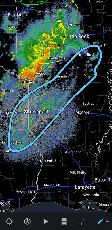
Alright Arkansas people, what is the story on Perry County's Northwest border? Did the town drunk draw that thing?
they thought they were designing a house instead of a county border and that's where the stairwell was going to go
 0
0


Posted on 4/13/22 at 11:20 am to LegendInMyMind
quote:
FWIW, the only PDS I pulled on the HRRR was generally in North central LA. I didn't save it and couldn't find it again.
I just pulled one on the 15z HRRR in western MS, not far from where MS, AR, and LA all come together. Valid at 4pm CDT this afternoon.

Posted on 4/13/22 at 11:22 am to Roll Tide Ravens
Interesting bit of embedded rotation NW of Texarkana.
Posted on 4/13/22 at 11:23 am to Roll Tide Ravens

Posted on 4/13/22 at 11:23 am to rt3

Posted on 4/13/22 at 11:25 am to Roll Tide Ravens
Its contaminated due to the convection ongoing. Which cranks the tornado potential for the sounding.
Posted on 4/13/22 at 11:26 am to Roll Tide Ravens
quote:
I just pulled one on the 15z HRRR in western MS, not far from where MS, AR, and LA all come together. Valid at 4pm CDT this afternoon.
One thing to watch for when pulling soundings from models is contamination. Sometimes if you pull one from an area with convection already firing, that convection can contaminate the sounding. The key way to tell this are the red lines on the left extending way too far to the right. Another is the dew and temp being abnormally/unusually close together throughout the column. You can usually pick a slightly different spot or back the model up by an hour to get a clean sounding.
This post was edited on 4/13/22 at 11:28 am
Posted on 4/13/22 at 11:28 am to LegendInMyMind
Seems to me that broken line is moving pretty slow it’s been hanging around Texarkana for awhile.
I remember reading yesterday the reason discrete cells were possible in my area is the tail end was expected to lag behind allowing for daytime heating and increased instability
I remember reading yesterday the reason discrete cells were possible in my area is the tail end was expected to lag behind allowing for daytime heating and increased instability
Posted on 4/13/22 at 11:29 am to LegendInMyMind
Thanks for pointing that out Duke and Legend! I'm still learning about reading soundings. Now I know something new.
Posted on 4/13/22 at 11:29 am to LegendInMyMind
quote:
generally in North central LA.
Legend, in this case does North Central LA mean east or west of a line from, say, Ruston to Alexandria?
Posted on 4/13/22 at 11:34 am to lachellie
New SPC convective outlook:

Tornado probs

Severe wind probs

Tornado probs
Severe wind probs
Posted on 4/13/22 at 11:52 am to lachellie
Watch all these little boundaries starting to show up. Cells/storms can fire along any of those as we start to get toward the heating of the day.
Posted on 4/13/22 at 11:55 am to Roll Tide Ravens
Moderate Extended south just like I figured
Timing of it arriving here keeps getting pushed back later. Earlier this morning it was 2pm now saying 4pm. Which is bad news
Timing of it arriving here keeps getting pushed back later. Earlier this morning it was 2pm now saying 4pm. Which is bad news
This post was edited on 4/13/22 at 11:58 am
Posted on 4/13/22 at 12:00 pm to deltaland
I think that line of storms will move across central Arkansas toward Memphis and everything south will have discrete cell potential this afternoon
Posted on 4/13/22 at 12:02 pm to deltaland
He, Wishin....there's also a radar down near Hernando that I didn't know about:
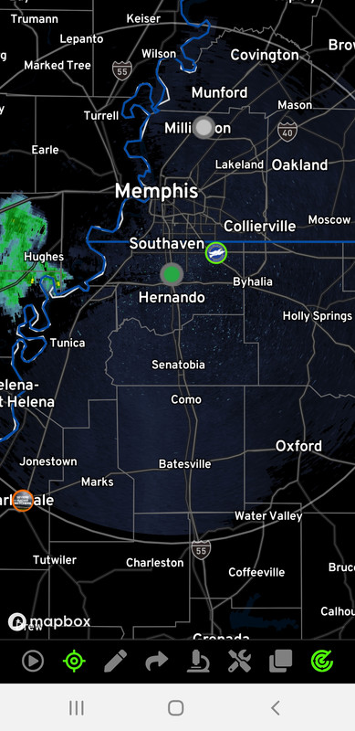
It isn't dual-pol, but it is another that can show Base data.
ETA: Nevermind, that's the airport one that shows up on RadarScope. It is just labeled differently on Omega. Carry on....
It isn't dual-pol, but it is another that can show Base data.
ETA: Nevermind, that's the airport one that shows up on RadarScope. It is just labeled differently on Omega. Carry on....
This post was edited on 4/13/22 at 12:05 pm
Posted on 4/13/22 at 12:15 pm to LegendInMyMind
Yea I knew that one was there, won’t quite get here sadly plus isn’t dual pole
Ohh well, I figured when the cows start flying by it’s time to take cover
Ohh well, I figured when the cows start flying by it’s time to take cover
Posted on 4/13/22 at 12:18 pm to Wishnitwas1998
Yeah, I noticed what it was after I posted.
Posted on 4/13/22 at 12:37 pm to LegendInMyMind

Posted on 4/13/22 at 12:46 pm to Roll Tide Ravens
What MPH wind triggers the warning/probability?
Posted on 4/13/22 at 12:50 pm to Roll Tide Ravens
quote:
Thanks for pointing that out Duke and Legend! I'm still learning about reading soundings. Now I know something new.
Grabbing a contaminated sounding is basically a rite of passage on the journey.
This post was edited on 4/13/22 at 12:51 pm

 Page 46 of 81

Popular
Back to top