- My Forums
- Tiger Rant
- LSU Score Board
- LSU Recruiting
- SEC Rant
- SEC Score Board
- Saints Talk
- Pelicans Talk
- More Sports Board
- Coaching Changes
- Fantasy Sports
- Golf Board
- Soccer Board
- O-T Lounge
- Tech Board
- Home/Garden Board
- Outdoor Board
- Health/Fitness Board
- Movie/TV Board
- Book Board
- Music Board
- Political Talk
- Money Talk
- Fark Board
- Gaming Board
- Travel Board
- Food/Drink Board
- Ticket Exchange
- TD Help Board
Customize My Forums- View All Forums
- Show Left Links
- Topic Sort Options
- Trending Topics
- Recent Topics
- Active Topics
Started By
Message


 0
0

Posted on 3/14/25 at 5:14 am to East Coast Band
So the consensus for the Spring Breakers in PCB FL traveling back to Oxford is for them to leave today or Sunday?
I have not been able to get a hold of my son but sent him a text about the risk of traveling back on Saturday and also the risk in Oxford.
Still no reply from him. I may resort to sending his GF a text. It may not change their travel plans but at least I will know just how much and what to worry about on Saturday if I know what they are doing.
Ugh. Like Spring Break in FL wasn't enough to worry about?
Posted on 3/14/25 at 5:49 am to Bobby OG Johnson
Well bama, it was nice knowing you

Posted on 3/14/25 at 6:00 am to RebelSquared
quote:
Oxford
quote:
I may resort to sending his GF a text.
Be careful, that is how it started with Mary Kate and how she ended up being a 50+ page long thread on tOT.
Posted on 3/14/25 at 6:17 am to jsmoove
Times like these I miss Glenn Burns, he was our James Spann.
My Atlanta peeps know.
My Atlanta peeps know.
This post was edited on 3/14/25 at 6:50 am
Posted on 3/14/25 at 7:16 am to LegendInMyMind
quote:
We haven't had one like this in a while.
These conditions are very favorable for tornadoes
quote:
The exit region of the mid-level jet streak is forecast to move across the lower Mississippi Valley and Tennessee during the mid to late afternoon, which will be timed well with afternoon max heating. Forecast soundings at 21Z across parts of southern and central Mississippi have MLCAPE in the 2000 to 3500 J/kg range, with 0-6 km shear of 70 to 80 knots. 700-500 mb lapse rates are forecast to be near 8 C/km, with 0-3 km storm-relative helicity in the 400 to 500 m2/s2 range. This will be very favorable for intense severe storms, with a threat for tornadoes, wind damage and large hail. Several tornadic supercells are expected to develop within this cluster by mid to late afternoon as the low-level jet intensifies. Multiple long-track high-end tornadoes will be possible. The greatest tornado threat is expected to shift into Alabama by early to mid evening, with a significant tornado threat also impacting parts of middle Tennessee.
Posted on 3/14/25 at 7:21 am to 4x4tiger
The problem with that map is that every single little cell that moves through is going to be trying to spin from Dauphin Island to Huntsville.
What I recall from some of the major outbreaks is that causes the NWS to miss smaller tornadoes as they have to worry about PDS situations for larger markets.
Hopefully we don’t get to that point tomorrow with this front, but it’s a concern.
And with this happening overnight at my location and the weather teams burned out from tracking all day I plan to stay up to look at this on my app rather than waiting on a warning that has often come late or not at all where I am.
Posted on 3/14/25 at 7:25 am to slackster
quote:
Kinda surprising because the HRRR isn’t exactly peachy for some of those areas.
That storm mode looks messy in Alabama, couldn’t that choke off the energy and stabilize the environment?
Doesn’t look good for south and central Ms though
Posted on 3/14/25 at 7:28 am to jsmoove
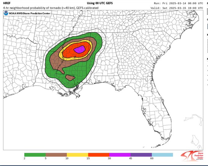
That looks way too low of probabilities for southern Ms
Posted on 3/14/25 at 7:30 am to deltaland
quote:
That storm mode looks messy in Alabama, couldn’t that choke off the energy and stabilize the environment?
That's my hope. Both HRRR and NAM delay what was tonight's storms into the early morning hours of Saturday, too. Those storms had been earlier on the lower res models. At the same time, though, the SPC has pushed the MOD risk area farther north.

Posted on 3/14/25 at 7:37 am to 4x4tiger
quote:
Well bama, it was nice knowing you
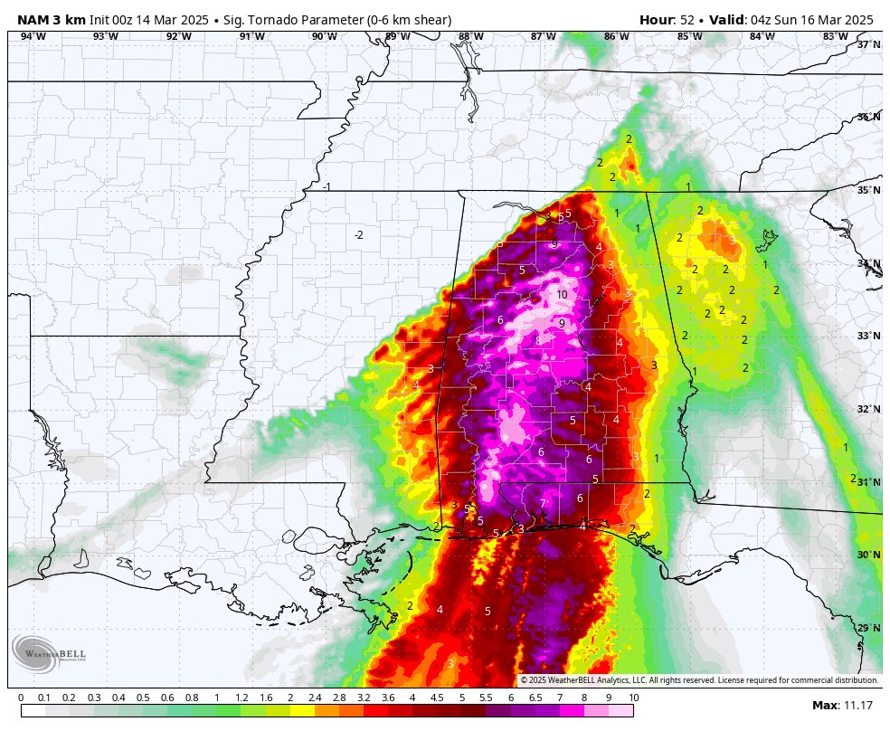
What do the numbers on this map represent? Rain totals?
Posted on 3/14/25 at 7:41 am to LegendInMyMind
quote:
Both HRRR and NAM delay what was tonight's storms into the early morning hours of Saturday, too
Chance if that pans out it would stabilize the air tomorrow?
Posted on 3/14/25 at 7:44 am to Obtuse1
quote:
Be careful, that is how it started with Mary Kate and how she ended up being a 50+ page long thread on tOT.
Thanks for the warning but since I am his mom and I am straight at least that is something I don't need to worry about.
Posted on 3/14/25 at 7:46 am to dallasga6
quote:
What do the numbers on this map represent?
This is the Significant Tornado Parameter. A significant tornado, shortened to Sigtor, is defined as an EF2+ tornado. The STP is a composite product that incorporates various other severe weather products/data to give an overall representation of an environment's capability to produce significant tornadoes. Saturday's environment is off the charts as far as STP is concerned.
However, taking the STP alone isn't very helpful in determining the overall threat or floor/ceiling of a setup.
Posted on 3/14/25 at 7:48 am to schwartzy
quote:
Chance if that pans out it would stabilize the air tomorrow?
It COULD help the North AL area. The HRRR still rebounds the environment pretty well between rounds of storms, though. There will just be a lot of spin in the atmosphere, so it won't take much to get things going.
Posted on 3/14/25 at 7:51 am to East Coast Band
The weather sensationalism is ridiculous. No one wants to go fishing today or tomorrow because they are scared of the weather. Nuts.
Posted on 3/14/25 at 7:53 am to Bigfishchoupique
quote:
The weather sensationalism is ridiculous. No one wants to go fishing today or tomorrow because they are scared of the weather. Nuts.
I don't see the problem with going today. I can see wanting to lay out and knock back a few beers at the house/camp tomorrow.
This post was edited on 3/14/25 at 8:00 am
Posted on 3/14/25 at 8:00 am to LegendInMyMind
We are going to have to drink our way through tomorrow. It’s the only way.
Posted on 3/14/25 at 8:08 am to genuineLSUtiger
Trying to decide whether to stay in Birmingham or head to mandeville.
Posted on 3/14/25 at 8:13 am to reds on reds on reds
If you’re going to Mandeville to avoid the weather that would be pointless. They could get a tornado too.
Just need to have a plan of where to go if you get a warning in your area. The odds of a tornado hitting your home is very low
Just need to have a plan of where to go if you get a warning in your area. The odds of a tornado hitting your home is very low

 Page 18 of 21

Popular
Back to top