- My Forums
- Tiger Rant
- LSU Recruiting
- SEC Rant
- Saints Talk
- Pelicans Talk
- More Sports Board
- Fantasy Sports
- Golf Board
- Soccer Board
- O-T Lounge
- Tech Board
- Home/Garden Board
- Outdoor Board
- Health/Fitness Board
- Movie/TV Board
- Book Board
- Music Board
- Political Talk
- Money Talk
- Fark Board
- Gaming Board
- Travel Board
- Food/Drink Board
- Ticket Exchange
- TD Help Board
Customize My Forums- View All Forums
- Show Left Links
- Topic Sort Options
- Trending Topics
- Recent Topics
- Active Topics
Started By
Message
re: Severe Weather Moving East Today
Posted on 1/10/20 at 11:52 pm to red sox fan 13
Posted on 1/10/20 at 11:52 pm to red sox fan 13
quote:
Been a windy day but now it feels like a hurricane is coming or I’m at the beach. Pretty ominous.
Windy.com is showing about 20 mph wind from the SE with gusts up to the low 40 mph.
We're getting a slightly higher wind (low 20s) but lower gusts (about 35 mph) and I can hear the shutters moving a bit outside. It's not enjoyable at all.
 1
1

Posted on 1/10/20 at 11:54 pm to rt3
quote:
tornado warning just outside Houston moving dead red to the center of the city
quote:
From 11:46pm CST, Fri Jan 10 until 12:15am CST, Sat Jan 11
Action Recommended: Take shelter in place or per instructions
Issued by: Houston/Galveston - TX, US, National Weather Service,
THE NATIONAL WEATHER SERVICE IN LEAGUE CITY HAS ISSUED A * TORNADO WARNING FOR... NORTHEASTERN FORT BEND COUNTY IN SOUTHEASTERN TEXAS... SOUTH CENTRAL HARRIS COUNTY IN SOUTHEASTERN TEXAS... * UNTIL 1215 AM CST. * AT 1146 PM CST, A SEVERE THUNDERSTORM CAPABLE OF PRODUCING A TORNADO WAS LOCATED OVER FOUR CORNERS, OR OVER TOWN WEST, MOVING NORTHEAST AT 40 MPH. HAZARD...TORNADO. SOURCE...RADAR INDICATED ROTATION. IMPACT...FLYING DEBRIS WILL BE DANGEROUS TO THOSE CAUGHT WITHOUT SHELTER. MOBILE HOMES WILL BE DAMAGED OR DESTROYED. DAMAGE TO ROOFS, WINDOWS, AND VEHICLES WILL OCCUR. TREE DAMAGE IS LIKELY. * THIS DANGEROUS STORM WILL BE NEAR... STAFFORD, MEADOWS PLACE AND WESTCHASE AROUND 1155 PM CST. NORTHERN MISSOURI CITY, ALIEF, WESTWOOD, BRAEBURN, BRAYS OAKS, MID WEST AND BRIAR FOREST AROUND 1200 AM CST. BELLAIRE, HUNTERS CREEK VILLAGE, BUNKER HILL VILLAGE, PINEY POINT VILLAGE, SPRING VALLEY, HEDWIG VILLAGE, HILSHIRE VILLAGE, SHARPSTOWN, GULFTON AND THE GALLERIA AROUND 1205 AM CST. WEST UNIVERSITY PLACE, GREENWAY / UPPER KIRBY AREA, AFTON OAKS / RIVER OAKS AREA, SOUTHWESTERN MEMORIAL PARK, SOUTHSIDE PLACE, BRAESWOOD, GREATER UPTOWN, SOUTH MAIN AND SPRING BRANCH EAST AROUND 1210 AM CST. OTHER LOCATIONS IMPACTED BY THIS TORNADIC THUNDERSTORM INCLUDE MEMORIAL. PRECAUTIONARY/PREPAREDNESS ACTIONS... TAKE COVER NOW! MOVE TO A BASEMENT OR AN INTERIOR ROOM ON THE LOWEST FLOOR OF A STURDY BUILDING. AVOID WINDOWS. IF YOU ARE OUTDOORS, IN A MOBILE HOME, OR IN A VEHICLE, MOVE TO THE CLOSEST SUBSTANTIAL SHELTER AND PROTECT YOURSELF FROM FLYING DEBRIS. TORNADOES ARE EXTREMELY DIFFICULT TO SEE AND CONFIRM AT NIGHT. DO NOT WAIT TO SEE OR HEAR THE TORNADO. TAKE COVER NOW! && TORNADO...RADAR INDICATED HAIL...<.75IN
This post was edited on 1/10/20 at 11:55 pm

Posted on 1/10/20 at 11:55 pm to rt3
quote:
tornado warning just outside Houston moving dead red to the center of the city
Well... That ain’t good.
Posted on 1/10/20 at 11:59 pm to rds dc
11:36 pm : MSY ASOS recorded peak wind gust of 34 knots (39 mph).
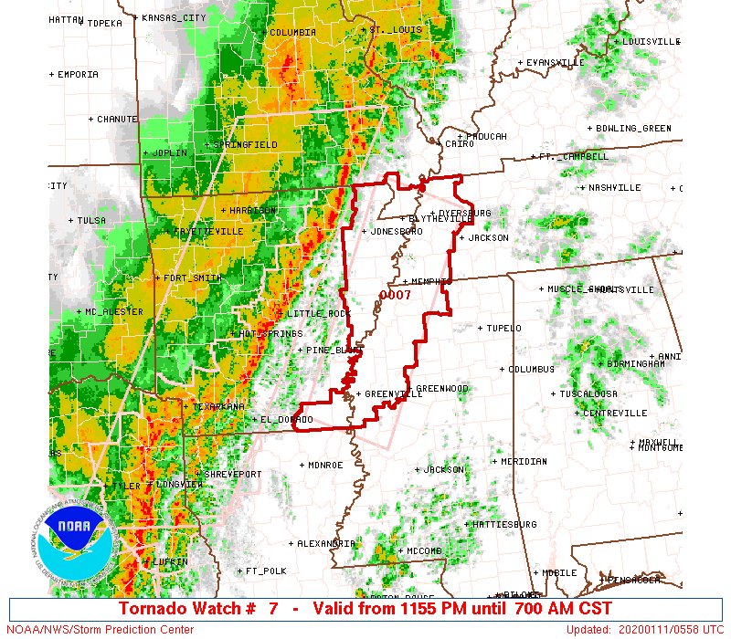
Posted on 1/11/20 at 12:00 am to bbrownso
new tornado watch
Posted on 1/11/20 at 12:02 am to red sox fan 13
quote:
Well... That ain’t good.
TWC seemed to indicate the tornadic potential of that storm was lessening but high wind potential was still there
Posted on 1/11/20 at 12:10 am to rt3
new tornado watch coming soon covering southeast Texas to CenLA

Posted on 1/11/20 at 12:14 am to rt3
I’m at a hotel in Batesville, AR and we are getting terrible weather right now. Of course my room is on the top (4th) floor and in the corner of the building.
Posted on 1/11/20 at 12:15 am to TigerFanInSouthland
Sirens going off in Marshall, TX.

Posted on 1/11/20 at 12:15 am to Bullfrog
quote:
I’m supposed to meat some bro’s
Posted on 1/11/20 at 12:17 am to LSUneaux
stay safe, that shite looks bad
were getting pounded by rain, they expect major flooding by 2morrow, in the off shoot rivers of Miss/Missouri rivers. Especially Meramec river.
were getting pounded by rain, they expect major flooding by 2morrow, in the off shoot rivers of Miss/Missouri rivers. Especially Meramec river.
Posted on 1/11/20 at 12:19 am to SeeeeK
Gulf Coast-style thunder and lightning and torrential rainfall. It’s been two fricking hours now. Satellite tv is out. I’m just chilling in the lobby so I don’t have to hear the wind and thunder. Hopefully this passes in the next 15-30 minutes.
Posted on 1/11/20 at 12:20 am to rt3
60-70 mph straight line winds in Marshall, TX
Posted on 1/11/20 at 12:23 am to LSUneaux
Yeah I’ve always wondered why every time I’m at the beach and rain is in the forecast, it storms hard as hell.

Posted on 1/11/20 at 12:25 am to rt3
Houston might be a worse place than Dallas for a tornado to hit. At least we won’t drown after the glass rips us to shreds.
Posted on 1/11/20 at 12:27 am to Lsuhoohoo
quote:
60-70 mph straight line winds in Marshall, TX
Wow

Posted on 1/11/20 at 12:28 am to LSUGrrrl
All good here in the Upper Kirby/Montrose area
Posted on 1/11/20 at 12:37 am to offshoreangler
I’m sitting out on my back porch in Benton right now enjoying the light show.
...for now
...for now
This post was edited on 1/11/20 at 12:39 am
Posted on 1/11/20 at 12:45 am to TigerFanInSouthland
Tornado warnings are popping up near you just to the west. Your area along with the whole Shreveport metro are about to get slammed
Posted on 1/11/20 at 12:46 am to TigerFanInSouthland
Joe Haynes (KTBS 3 Shreveport meteorologist) just reported 90 mph winds at state line.

 Page 34 of 51

Popular
Back to top