- My Forums
- Tiger Rant
- LSU Recruiting
- SEC Rant
- Saints Talk
- Pelicans Talk
- More Sports Board
- Coaching Changes
- Fantasy Sports
- Golf Board
- Soccer Board
- O-T Lounge
- Tech Board
- Home/Garden Board
- Outdoor Board
- Health/Fitness Board
- Movie/TV Board
- Book Board
- Music Board
- Political Talk
- Money Talk
- Fark Board
- Gaming Board
- Travel Board
- Food/Drink Board
- Ticket Exchange
- TD Help Board
Customize My Forums- View All Forums
- Show Left Links
- Topic Sort Options
- Trending Topics
- Recent Topics
- Active Topics
Started By
Message
 1
1

Posted on 1/10/20 at 11:24 am to shel311
quote:
quote:Its gonna get spooky here starting at 2.Thanks! Looks like I'm leaving work at 12p.
This is the most recent short range model run. This graphic is at 1PM.


Posted on 1/10/20 at 11:31 am to slackster
Lots of small cells firing off along 35W Corridor

Posted on 1/10/20 at 11:34 am to East Coast Band
quote:
They might as well put up a tornado watch for a large area now
There is a watch now for the area where the warnings are/were.
This post was edited on 1/10/20 at 11:35 am
Posted on 1/10/20 at 11:36 am to TDsngumbo
quote:
Does it look like the BR area is at risk for these winds too or is it just north LA?
BR is just under the hatched area for tomorrow, but the Florida Parishes are all under the gun for now:


Posted on 1/10/20 at 11:40 am to GEAUXmedic
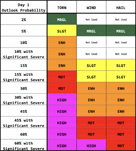
Question about hatched - it states that it means significant. Why not just bump it up into the next color? Or is hatched a step in between bumping up to the next probability color
Posted on 1/10/20 at 11:46 am to slackster
Enhanced risk for tomorrow has been pulled further north. Includes nearly all of Mississippi and Alabama in the enhanced risk.

This post was edited on 1/10/20 at 11:47 am
Posted on 1/10/20 at 11:47 am to rds dc
quote:
Where is that and what time did you pull it for?
Benton County, AR. Around 4pm
Posted on 1/10/20 at 11:48 am to TigerTatorTots
Yep. The entire state of AL is now covered under the enhanced risk. Haven't had time to read the day 2 Outlook, but I suspect the chances of supercell formation out front will be greater. Wind is going to be significant on this one, tornado or not.
Posted on 1/10/20 at 11:52 am to TigerTatorTots
quote:
Question about hatched - it states that it means significant. Why not just bump it up into the next color? Or is hatched a step in between bumping up to the next probability color
NOAA conversion table might help:
ETA -
quote:
Sometimes, a black hatched area will be overlaid with the severe probabilities. Black hatching means a 10% or higher probability for significant severe events within 25 miles of any point. "Significant" is defined as: tornadoes rated EF2 or greater, thunderstorm wind gusts of hurricane force (74 mph) or higher, or hail 2 inches or larger in diameter.
This post was edited on 1/10/20 at 11:55 am
Posted on 1/10/20 at 11:53 am to Roll Tide Ravens
RDS
Why is this lining out already?

Why is this lining out already?
Posted on 1/10/20 at 11:56 am to slackster
quote:
BR is just under the hatched area for tomorrow, but the Florida Parishes are all under the gun for now:
Baton Rouge is still included in the Hatched area for tomorrow.

Posted on 1/10/20 at 12:00 pm to lsuman25
One thing I dont miss about louisiana is the severe outbreak of random weather.
One time in 2009 lightning stuck my house from a small cell of a storm that came out of nowhere and lasted only 10 minutes. In those 10 minutes I lost a computer with all the work i had on it.
I was so pissed that I immediately went bought an exact one and just pretended it never happened.
One time in 2009 lightning stuck my house from a small cell of a storm that came out of nowhere and lasted only 10 minutes. In those 10 minutes I lost a computer with all the work i had on it.
I was so pissed that I immediately went bought an exact one and just pretended it never happened.
Posted on 1/10/20 at 12:06 pm to 50_Tiger
quote:
Why is this lining out already?
I don't think it is permanently, just a small feature.
Posted on 1/10/20 at 12:08 pm to slackster
iirc the main show is supposed to be here later. Is this ahead of schedule?

Posted on 1/10/20 at 12:14 pm to 50_Tiger

Posted on 1/10/20 at 12:15 pm to slackster
Will these straight line winds be coming directly from the west?
Posted on 1/10/20 at 12:16 pm to biggsc

Posted on 1/10/20 at 12:16 pm to 50_Tiger
quote:
Why is this lining out already?
I would call that clustering vs "lining" out, esp since they are in the open warm sector. Those cells could cause some trouble up in Oklahoma as they mature. Later on, storms should line out pretty quickly because of how the winds (shear) are oriented with regards to the front.
Posted on 1/10/20 at 12:16 pm to biggsc

New Tornado watch coming shortly

 Page 16 of 51

Popular
Back to top