- My Forums
- Tiger Rant
- LSU Recruiting
- SEC Rant
- Saints Talk
- Pelicans Talk
- More Sports Board
- Fantasy Sports
- Golf Board
- Soccer Board
- O-T Lounge
- Tech Board
- Home/Garden Board
- Outdoor Board
- Health/Fitness Board
- Movie/TV Board
- Book Board
- Music Board
- Political Talk
- Money Talk
- Fark Board
- Gaming Board
- Travel Board
- Food/Drink Board
- Ticket Exchange
- TD Help Board
Customize My Forums- View All Forums
- Show Left Links
- Topic Sort Options
- Trending Topics
- Recent Topics
- Active Topics
Started By
Message
Severe Weather: April 27-29, 2026
Posted on 4/27/26 at 7:19 pm

Posted on 4/27/26 at 7:19 pm


This post was edited on 4/29/26 at 5:38 am
 9
9

Posted on 4/27/26 at 7:20 pm to Roll Tide Ravens
I'll be in here more so later when things ramp up in our area 

Posted on 4/27/26 at 7:35 pm to Roll Tide Ravens
Water from the sky


Posted on 4/27/26 at 7:37 pm to Roll Tide Ravens
Hoping for some more rain here in gods country
Posted on 4/27/26 at 7:40 pm to HeadSlash
quote:
Water from the sky
Here is your attention....
Posted on 4/27/26 at 7:41 pm to HeadSlash
quote:
HeadSlash
I would genuinely like to know why these threads bother you. I’ve asked before when you’ve made this same post in previous severe weather threads but you never respond.
There have been damaging storms today, and over the last several days. Not sure why you think it’s just rain.
This post was edited on 4/27/26 at 7:41 pm
Posted on 4/27/26 at 7:44 pm to HeadSlash
quote:
Water from the sky
Mine has been frozen so far. Hope my cars aren't too beat up.
Posted on 4/27/26 at 7:58 pm to Roll Tide Ravens
The northernmost warning in IL looks like it is close to putting one down.

Posted on 4/27/26 at 8:06 pm to LegendInMyMind
ORD been battling 3 hour inbound delays all day. DFW has about 40 planes in line to takeoff for the eastbound flights due to the storms just south and east of the airfield
Posted on 4/27/26 at 8:13 pm to CuseTiger
Posted on 4/27/26 at 8:17 pm to Cosmo
Kind of stating the obvious at this point but tonight is shaping up to be a rough one. Hopefully at least we all get some much needed rain
Posted on 4/27/26 at 8:20 pm to Wishnitwas1998
Getting really active in Missouri and Illinois now.
Posted on 4/27/26 at 8:20 pm to Wishnitwas1998
We had hail and tornadadic activity throughout St. Louis area today. Currently sitting in a power outage.
Posted on 4/27/26 at 8:21 pm to Roll Tide Ravens
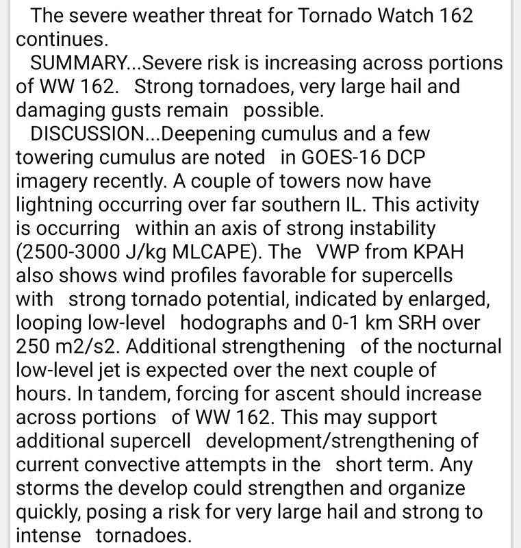
Confirmed large and extremely dangerous tornado near Carlyle, IL, east of St. Louis.
Severe Weather Statement
National Weather Service St Louis MO
819 PM CDT Mon Apr 27 2026
...TORNADO WARNING REMAINS IN EFFECT UNTIL 9 PM CDT FOR NORTHEASTERN CLINTON, SOUTHERN FAYETTE AND MARION COUNTIES IN SOUTH CENTRAL ILLINOIS...
At 819 PM CDT, a confirmed and extremely dangerous tornado was located over Carlyle, moving east at 45 mph.
This is a PARTICULARLY DANGEROUS SITUATION. TAKE COVER NOW!
HAZARD...Damaging tornado and quarter size hail.
SOURCE...Radar confirmed tornado.
IMPACT...You are in a life-threatening situation. Flying debris may be deadly to those caught without shelter. Mobile homes will be destroyed. Considerable damage to homes, businesses, and vehicles is likely and complete destruction is possible.
This tornado will be near... Carlyle around 820 PM CDT. Shattuc around 830 PM CDT. Sandoval, Boulder and Central City around 835 PM CDT.
Other locations impacted by the tornado include Posey, Huey, Hoffman, Ferrin, Keyesport, Junction City, Selmaville, Tonti, Brubaker and Alma.
Posted on 4/27/26 at 8:22 pm to Roll Tide Ravens
Tornado debris signature right over Carlyle.
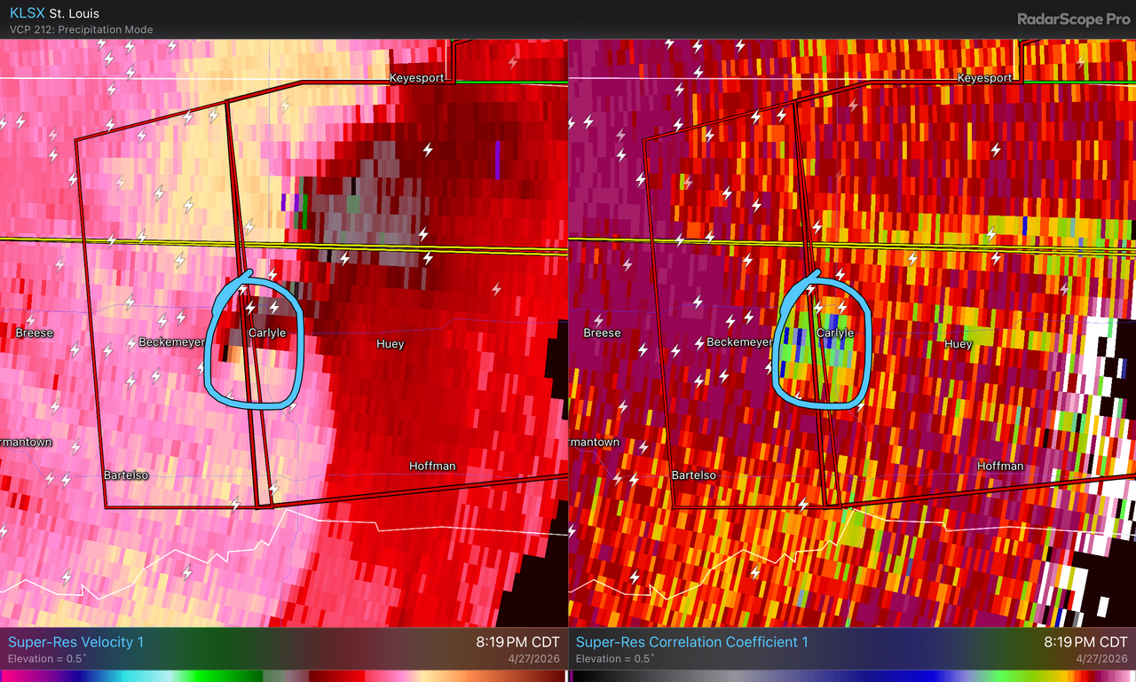
This post was edited on 4/27/26 at 8:24 pm
Posted on 4/27/26 at 9:15 pm to Roll Tide Ravens
Severe thunderstorm warning in north MS.
Loading Twitter/X Embed...
If tweet fails to load, click here.
Posted on 4/27/26 at 9:21 pm to Roll Tide Ravens
Cool, just as I’m driving to Little Rock tomorrow
Posted on 4/27/26 at 9:54 pm to Roll Tide Ravens
Posted on 4/27/26 at 10:01 pm to Roll Tide Ravens
Warnings from Indianapolis to Arkansas right now.

 Page 1 of 4

Popular
Back to top