





 1
1











- My Forums
- Tiger Rant
- LSU Recruiting
- SEC Rant
- Saints Talk
- Pelicans Talk
- More Sports Board
- Fantasy Sports
- Golf Board
- Soccer Board
- O-T Lounge
- Tech Board
- Home/Garden Board
- Outdoor Board
- Health/Fitness Board
- Movie/TV Board
- Book Board
- Music Board
- Political Talk
- Money Talk
- Fark Board
- Gaming Board
- Travel Board
- Food/Drink Board
- Ticket Exchange
- TD Help Board
Customize My Forums- View All Forums
- Show Left Links
- Topic Sort Options
- Trending Topics
- Recent Topics
- Active Topics
Started By
Message
re: Severe Weather - Today - LA, MS, AL, NW FL
Posted on 4/17/19 at 11:49 pm to Paul Allen
Posted on 4/17/19 at 11:49 pm to Paul Allen

quote:
Well if it’s on mutha fricka then it’s on
-BRgetthenet, 18 tee box at La Tour Golf Club
Posted on 4/17/19 at 11:52 pm to Winston Cup

Posted on 4/18/19 at 12:01 am to East Coast Band
I suggest drinking heavily. You sleep tight through this shite
Posted on 4/18/19 at 12:13 am to slackster
We are supposed to drive from Tuscaloosa to New Orleans tomorrow, leaving around 11. This is looking like a bad idea. Would driving down to Mobile, then cutting across improve conditions? Only add about 1.5 hours...
This post was edited on 4/18/19 at 12:24 am
Posted on 4/18/19 at 12:14 am to tigersownall
It's going through my area of DFW right now. Into the 15th minute. No wind. No hail. Some thunder and lightning and heavy rain that's already easing up.
They shut down Love Field for this? Pfft.
They shut down Love Field for this? Pfft.
Posted on 4/18/19 at 12:26 am to HubbaBubba

Posted on 4/18/19 at 12:28 am to GEAUXmedic
Hope everyone stays safe tonight and tomorrow.
Posted on 4/18/19 at 12:32 am to momentoftruth87
Lighting strikes. But no thunder. Rain not super heavy in sw Austin
Posted on 4/18/19 at 12:34 am to Winston Cup
Regardless, my thoughts are with anyone in the path of any storm. I'm up North and supposed to start storming at 2am-12 tomorrow.
It just snowed here the other day and it was 70s two days later
It just snowed here the other day and it was 70s two days later
This post was edited on 4/18/19 at 12:35 am
Posted on 4/18/19 at 12:46 am to momentoftruth87
ETA2: Hmmm... It's not there anymore. False alarm. Sorry guys
quote:
Local NBC reporting tornadic activity in Carrollton and Lewisville.
NBC Radar
ETA: Click Layers and enable Storm Track option.
This post was edited on 4/18/19 at 12:53 am
Posted on 4/18/19 at 12:48 am to momentoftruth87
The weather report is fraud. That was a very weak storm and we were supposed to get hit hard. The weatherman is full of shite. Expect good weather Easter weekend
The radar isn’t accurately displaying this storm. Weak af
The radar isn’t accurately displaying this storm. Weak af
Posted on 4/18/19 at 12:55 am to Winston Cup
quote:would still rather be over-prepared than under-prepared.
The weather report is fraud. That was a very weak storm and we were supposed to get hit hard. The weatherman is full of shite. Expect good weather Easter weekend
The radar isn’t accurately displaying this storm. Weak a
Posted on 4/18/19 at 1:03 am to GEAUXmedic
SPC Update for tomorrow across the deep south.
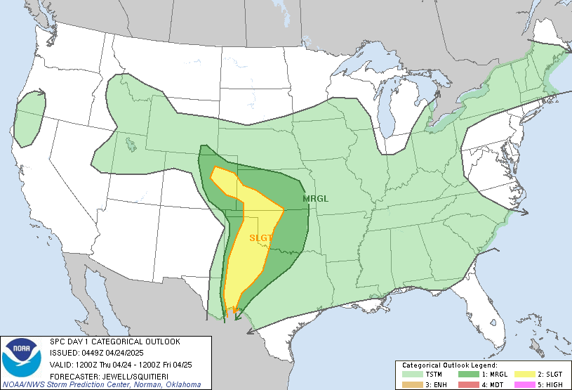
Summary:
Not much has changed, but the enhanced region is extended out east some.
Notably, the tornado risk is pegged for south MS and AL.

I'm not terribly surprised. Was thinking earlier today that it was southern Mississippi in for the better tornado risk.

Wind within the storms tomorrow is the biggest risk for us in south Louisiana.
Doing a late look at the short range modeling, it's been quite a spread. The 00z NAM has storms firing pretty early, like 10 am, and not having much instability in place. Overall, it's not showing any extreme scenarios. The HRRR is more bullish and gets the storms going a little later. Soundings produced are suggestive of stronger tornado potential, but the linear/cluster presentation isn't likely to yield that.
The HRW sets set the best tornado risk north of Louisiana too, with a cluster/line coming through after lunch.
Overall, not too bad for Louisiana as it stands but uncertainty remains.
Summary:
quote:
Severe thunderstorms are possible today across the lower Mississippi Valley through the central Gulf Coast states, accompanied by the risk for damaging wind gusts and a few tornadoes, some of which could become strong.
quote:
Some uncertainty exists concerning how quickly thunderstorms will redevelop and intensify along eastward advancing outflow generated by ongoing thunderstorm activity now spreading through eastern Texas. There appears likely to be at least some stabilization of mid-level lapse rates. However, guidance indicates that southerly 850 mb flow may strengthen in excess of 50 kt, inland of the Louisiana coast through Mississippi, as early as the 18-21Z time frame. This probably will be accompanied by a corridor of considerable boundary layer moistening, with guidance indicating surface dew points increasing through the upper 60s to near 70 F as far north as at least much of southern/southwestern Mississippi, contributing to CAPE of 1000-1500 J/kg.
Aided by strongly difluent and divergent upper flow, and strong
vertical shear, a gradually intensifying and organizing squall line
is expected to be accompanied by increasing potential for damaging
wind gusts, and perhaps a few embedded tornadoes. As the convective
system advances eastward, it may be preceded by discrete supercell
development, and a weak warm frontal zone, which may provide the
focus for large clockwise curved low-level hodographs supportive of
a risk for tornadoes. A couple of these could become strong,
perhaps as far east as southeastern Alabama by late tonight.
Not much has changed, but the enhanced region is extended out east some.
Notably, the tornado risk is pegged for south MS and AL.
I'm not terribly surprised. Was thinking earlier today that it was southern Mississippi in for the better tornado risk.
Wind within the storms tomorrow is the biggest risk for us in south Louisiana.
Doing a late look at the short range modeling, it's been quite a spread. The 00z NAM has storms firing pretty early, like 10 am, and not having much instability in place. Overall, it's not showing any extreme scenarios. The HRRR is more bullish and gets the storms going a little later. Soundings produced are suggestive of stronger tornado potential, but the linear/cluster presentation isn't likely to yield that.
The HRW sets set the best tornado risk north of Louisiana too, with a cluster/line coming through after lunch.
Overall, not too bad for Louisiana as it stands but uncertainty remains.
Posted on 4/18/19 at 1:08 am to Duke
Get your porn in before the power goes out.
Posted on 4/18/19 at 1:39 am to Langland
Traffic is backed up for miles right now due to the Governor's last minute Contraflow plan. I'm sitting on I-10 waiting to move and praying I have enough gas to make it to the next gas station.
Posted on 4/18/19 at 1:47 am to Duke
Looks like Central Alabama got chiseled out of the "enhanced
area.
area.
Posted on 4/18/19 at 1:48 am to MrLSU
Contraflow to where?
Posted on 4/18/19 at 3:33 am to ToulaTiger31
Will we be safe if my family and I evacuated to Florida?
Posted on 4/18/19 at 3:48 am to ToulaTiger31
He’s just trying to troll and doing a really bad job at it.
Posted on 4/18/19 at 4:10 am to Saltwatersoul04
I've charged up my laptop, tablet, phone and nintendo switch.
Should be good to go.
Should be good to go.

 Page 23 of 69



Popular

Back to top
 Follow TigerDroppings for LSU Football News