- My Forums
- Tiger Rant
- LSU Recruiting
- SEC Rant
- Saints Talk
- Pelicans Talk
- More Sports Board
- Fantasy Sports
- Golf Board
- Soccer Board
- O-T Lounge
- Tech Board
- Home/Garden Board
- Outdoor Board
- Health/Fitness Board
- Movie/TV Board
- Book Board
- Music Board
- Political Talk
- Money Talk
- Fark Board
- Gaming Board
- Travel Board
- Food/Drink Board
- Ticket Exchange
- TD Help Board
Customize My Forums- View All Forums
- Show Left Links
- Topic Sort Options
- Trending Topics
- Recent Topics
- Active Topics
Started By
Message
 1
1

Posted on 9/13/20 at 6:45 pm to jimmy the leg
quote:
Madisonville has zip for protection that I am aware of.
The actual city of Madisonville has the swamp people decided to build subdivisions in and call Madisonville to protect it.

Posted on 9/13/20 at 6:45 pm to NorthEndZone
Everything I’m seeing indicates a MS landfall. Curious about how far they shift the cone East
Posted on 9/13/20 at 6:46 pm to Delacroix22
quote:In tropical weather threads on this board "better" means the storm is going to do more property damage and kill more people.
When y’all are saying it looks better.... does that mean it looks stronger? Or it looks better like it’s weakening and better for our outcome?
See the logic??

Posted on 9/13/20 at 6:47 pm to rmnldr
quote:
Curious about how far they shift the cone East
My guess is NOLA will be on the far western edge of the new cone and the eastern edge will be near Mobile. Landfall near Gulfport-MS/AL line.
This post was edited on 9/13/20 at 6:47 pm

Posted on 9/13/20 at 6:47 pm to TDsngumbo
That would be a pretty radical move for just one cycle would it not?
Posted on 9/13/20 at 6:47 pm to TDsngumbo
quote:
My guess is NOLA will be on the far western edge of the new cone and the eastern edge will be near Mobile. Landfall near Gulfport-MS/AL line.
How much of a H is this?
Posted on 9/13/20 at 6:48 pm to LSURussian
quote:
Philippe Papin
@pppapin
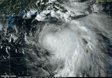
While #Sally has not intensified much today, convection has undergone significant evolution. A bursting pattern is ongoing w/ the deepest convection rotating into the NE quadrant. This distribution may slow the W motion & foreshadow strengthening if convection rotates upshear.
Posted on 9/13/20 at 6:49 pm to geauxtigers87
I don’t think so. The models have trended much further East all day today. Only one to wait for now is the 18z EURO very soon. I’d assume that’s going to shift eastward too.

Posted on 9/13/20 at 6:49 pm to slackster
I really thought she’d be a little more organized by now...
Thanks for all the info.
Thanks for all the info.
Posted on 9/13/20 at 6:49 pm to slackster
Karina is in the Pacific
Posted on 9/13/20 at 6:51 pm to rmnldr
Pascagoula is not in the Hurricane Warning as of yet and Morgan City is right now. I think that may be changing soon.
Pascagoula might get some of the worst weather from Sally.
Pascagoula might get some of the worst weather from Sally.
This post was edited on 9/13/20 at 6:52 pm
Posted on 9/13/20 at 6:52 pm to geauxtigers87
I don’t care about the center I am more concerned about over a foot of rain... nola gonna have some serious street flooding and all the creeks will be swollen and some roads impassable in Pearl River County where I reside. This will be more of a rain even unless ole sally gets it together then hold on to ya butts
Posted on 9/13/20 at 6:55 pm to NorthEndZone
quote:
000
WTNT34 KNHC 132353
TCPAT4
BULLETIN
Tropical Storm Sally Intermediate Advisory Number 9A
NWS National Hurricane Center Miami FL AL192020
700 PM CDT Sun Sep 13 2020
...SALLY FORECAST TO STRENGTHEN AND SLOW DOWN...
...LIFE-THREATENING STORM SURGE, HURRICANE-FORCE WINDS, AND HEAVY
RAINFALL EXPECTED ALONG PORTIONS OF THE NORTHERN GULF COAST
STARTING ON MONDAY...
SUMMARY OF 700 PM CDT...0000 UTC...INFORMATION
----------------------------------------------
LOCATION...27.9N 86.2W
ABOUT 160 MI...260 KM S OF PANAMA CITY FLORIDA
ABOUT 195 MI...315 KM ESE OF THE MOUTH OF THE MISSISSIPPI RIVER
MAXIMUM SUSTAINED WINDS...60 MPH...95 KM/H
PRESENT MOVEMENT...WNW OR 295 DEGREES AT 9 MPH...15 KM/H
MINIMUM CENTRAL PRESSURE...996 MB...29.41 INCHES
WATCHES AND WARNINGS
--------------------
CHANGES WITH THIS ADVISORY:
None
Posted on 9/13/20 at 6:55 pm to bayoudude
...SALLY FORECAST TO STRENGTHEN AND SLOW DOWN... ...LIFE-THREATENING STORM SURGE, HURRICANE-FORCE WINDS, AND HEAVY RAINFALL EXPECTED ALONG PORTIONS OF THE NORTHERN GULF COAST STARTING ON MONDAY...
7:00 PM CDT Sun Sep 13
Location: 27.9°N 86.2°W
Moving: WNW at 9 mph
Min pressure: 996 mb
Max sustained: 60 mph
7:00 PM CDT Sun Sep 13
Location: 27.9°N 86.2°W
Moving: WNW at 9 mph
Min pressure: 996 mb
Max sustained: 60 mph
Posted on 9/13/20 at 6:56 pm to mightynine
quote:
How much of a H is this?
Triple

Posted on 9/13/20 at 6:58 pm to geauxtigers87
quote:
That would be a pretty radical move for just one cycle would it not?
If you are depending on reliable info from this thread, please don't listen to that moron.
Posted on 9/13/20 at 6:59 pm to lsuman25

Posted on 9/13/20 at 6:59 pm to oOoLsUtIgErSoOo
quote:
quote:
That would be a pretty radical move for just one cycle would it not?
If you are depending on reliable info from this thread, please don't listen to that moron.
Let’s hear your prediction of where the cone will be and where landfall will be.

Posted on 9/13/20 at 7:02 pm to real turf fan
Madisonville is ok

 Page 84 of 298

Popular
Back to top