- My Forums
- Tiger Rant
- LSU Recruiting
- SEC Rant
- Saints Talk
- Pelicans Talk
- More Sports Board
- Coaching Changes
- Fantasy Sports
- Golf Board
- Soccer Board
- O-T Lounge
- Tech Board
- Home/Garden Board
- Outdoor Board
- Health/Fitness Board
- Movie/TV Board
- Book Board
- Music Board
- Political Talk
- Money Talk
- Fark Board
- Gaming Board
- Travel Board
- Food/Drink Board
- Ticket Exchange
- TD Help Board
Customize My Forums- View All Forums
- Show Left Links
- Topic Sort Options
- Trending Topics
- Recent Topics
- Active Topics
Started By
Message
re: Sally - Moving towards Georgia - Potential for Significant Flooding
Posted on 9/13/20 at 10:40 am to tgrgrd00
Posted on 9/13/20 at 10:40 am to tgrgrd00
May be a dumb question, but is there a website or source I can see updated spaghetti models? I notice the news shows them less often and prefer to show the cone of uncertainty. Always found the models interesting to compare.
 2
2


Posted on 9/13/20 at 10:41 am to Buck_Rogers
tropicaltidbits has the models. weather.us has rainfall totals.
Posted on 9/13/20 at 10:41 am to TheFonz
I'm pretty sure the NHC has that on their site.

Posted on 9/13/20 at 10:42 am to rds dc
Need to hurry and cut my grass.

Posted on 9/13/20 at 10:43 am to Buck_Rogers
quote:
May be a dumb question, but is there a website or source I can see updated spaghetti models? I notice the news shows them less often and prefer to show the cone of uncertainty. Always found the models interesting to compare.
Tropical Tidbits page for Sally
Scroll down towards the bottom. They are updated every 6 hours.
This post was edited on 9/13/20 at 10:44 am
Posted on 9/13/20 at 10:43 am to Jake88
quote:But how many H's is that??
I just want to know if forecast track shifted any further west from 7 am to 10 am.
Yes, by about 15 miles or so.
Posted on 9/13/20 at 10:45 am to LSURussian
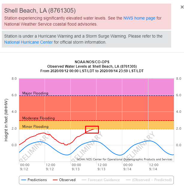
The storm surge is slowly starting in Shell Beach
Posted on 9/13/20 at 10:45 am to TheFonz
Posted on 9/13/20 at 10:46 am to MrLSU
If I change my profile pic to a little hurricane does that mean Sally won't mess with me, since I'm down with the cause?
Posted on 9/13/20 at 10:47 am to Jake88
GFS shifts east

Posted on 9/13/20 at 10:48 am to Jim Rockford
That 11 am track is less than desirable.... shite!
Posted on 9/13/20 at 10:49 am to stout
Low level center is still misaligned from the mid level center based on the most recent recon pass.

Yellow is LLC, blue is MLC. Those wind barbs are flight level, so the winds wrapping around from the N are not aligned with the N winds you can see in the visible imagery at the surface.
Expected at this point, but that’s what we’re watching for strengthening.
Yellow is LLC, blue is MLC. Those wind barbs are flight level, so the winds wrapping around from the N are not aligned with the N winds you can see in the visible imagery at the surface.
Expected at this point, but that’s what we’re watching for strengthening.
Posted on 9/13/20 at 10:50 am to MrLSU
quote:
The storm surge is slowly starting in Shell Beach
Water has been running higher then the norm down there.
Posted on 9/13/20 at 10:50 am to slackster
quote:
Well it actually shifted from Venice to GI, so... yeah, it didn’t shift all that far. 40 miles or so at best.
And y’all said a 50 mile miss was bad in the Laura thread, so we’re on the doorstep of a bad miss inside 48 hours
Posted on 9/13/20 at 10:50 am to LSURussian
quote:It moved from crossing along the causeway to riding up the I-55. In my opinion, based upon my alphabet training in kindergarten, I'd say that is about one "H" worth of westward shift.
But how many H's is that??
Posted on 9/13/20 at 10:51 am to Jake88
Uppercase or lowercase?
Posted on 9/13/20 at 10:51 am to Impotent Waffle
This is the latest Weather Prediction Center rainfall forecast:

Posted on 9/13/20 at 10:52 am to TheFonz
quote:
Okay stupid question from a weather idiot.
Does anyone know of a resource online that updates with the tracks they may give a general idea of projected wind speeds in a given area like Covington/Mandeville? Wind will be my biggest issue. I see sometimes the news channels do it but was wondering if it was online somewhere.
NHC Sally Page
Use this. The other sites like Tropical Tidbits and Weather.us require some level of context to understand what you’re seeing. NHC does a great job dumbing it down with all of the graphics.
Posted on 9/13/20 at 10:53 am to slackster
quote:
Low level center is still misaligned from the mid level center based on the most recent recon pass.
And this is due in part to the western wind shear? If so, I’m guessing these centers will become more aligned and therefore be favorable for strengthening once the shear subsides?

 Page 62 of 298

Popular
Back to top