- My Forums
- Tiger Rant
- LSU Recruiting
- SEC Rant
- Saints Talk
- Pelicans Talk
- More Sports Board
- Fantasy Sports
- Golf Board
- Soccer Board
- O-T Lounge
- Tech Board
- Home/Garden Board
- Outdoor Board
- Health/Fitness Board
- Movie/TV Board
- Book Board
- Music Board
- Political Talk
- Money Talk
- Fark Board
- Gaming Board
- Travel Board
- Food/Drink Board
- Ticket Exchange
- TD Help Board
Customize My Forums- View All Forums
- Show Left Links
- Topic Sort Options
- Trending Topics
- Recent Topics
- Active Topics
Started By
Message
re: Preliminary Ratings: Lacombe Tornado - EF1; NOLA/Arabi Tornado - EF3
Posted on 3/22/22 at 2:14 pm to Roll Tide Ravens
Posted on 3/22/22 at 2:14 pm to Roll Tide Ravens
I don't know what NWS Birmingham is going to decide to do, but folks in West Central AL near the state line need to be ready to treat this entire line like a tornado. It won't weaken any time soon.
 1
1

Posted on 3/22/22 at 2:14 pm to Duke
This is what I wanted to show. Would have been more interesting 20 minutes ago.
Posted on 3/22/22 at 2:16 pm to TDsngumbo
Looking like west Alabama might get more discreet cells than MS tbh
Meteorology credibility took a nosedive when they started using faulty computer models rather than common sense and input from random internet poster.
TD weather thread posters

“Experts” you see on tv and at the SPC

I kid
quote:
I read all the shite the NWS and SPC put out and then interpret it based on my historical observations . I’ve been trying to tell y’all this wasn’t
Meteorology credibility took a nosedive when they started using faulty computer models rather than common sense and input from random internet poster.
TD weather thread posters
“Experts” you see on tv and at the SPC
I kid

Posted on 3/22/22 at 2:16 pm to LegendInMyMind
quote:
LegendInMyMind
I'll say this about RadarOmega, it includes some features in its base version that you would need a tier 2 subscription to get in RadarScope. Such as SPC outlooks and changing the map type.
Posted on 3/22/22 at 2:20 pm to Roll Tide Ravens
quote:
I'll say this about RadarOmega, it includes some features in its base version that you would need a tier 2 subscription to get in RadarScope. Such as SPC outlooks and changing the map type.
Glad you checked it out. I'm liking it so far. One really good thing is that the RO crew is active in the met community and constantly works to fix issues with meaningful updates. That says alot.
I've followed them for a while now. Their 3D radar stuff got me interested.
This post was edited on 3/22/22 at 2:21 pm

Posted on 3/22/22 at 2:23 pm to Thracken13
quote:
what a coincidence! I'm an interpretive expert in you being full of shite.
You are correct in that I’m full of shite BUT this will very likely end up being a typical strong line of thunderstorms for sela. It’s been trending that way for 24 hours.
Posted on 3/22/22 at 2:24 pm to LegendInMyMind
Question for you experts. On Radar Scope, if I click on one of the dots and it says Meso strength 989, what does that mean?
What number would be considered a strong Meso strength?
What number would be considered a strong Meso strength?
Posted on 3/22/22 at 2:25 pm to bigcatfish
All clear where I am now .. thunder in the distance but Sun peeking out.
Just need my electricity back on!
Just need my electricity back on!
Posted on 3/22/22 at 2:25 pm to bigcatfish
you should really be worried when you click on it and it says MESO h0rn3y.

Posted on 3/22/22 at 2:26 pm to bigcatfish
Im no expert but I think I read on here a while back that higher than 4k is something to look at
This post was edited on 3/22/22 at 2:27 pm
Posted on 3/22/22 at 2:27 pm to Thracken13
I laughed to hard at that
Posted on 3/22/22 at 2:27 pm to deltaland
quote:
I laughed to hard at that
same
Posted on 3/22/22 at 2:30 pm to im4LSU
just tried to give a little light heartedness to the thread - the storms and impacts are serious, and rightfully so - but sometimes a little levity helps.
you all rock = even TD's....sometimes :P
you all rock = even TD's....sometimes :P
Posted on 3/22/22 at 2:36 pm to Thracken13
Ryan Hall has a storm chaser coming up on a tornado warned storm near Collinsville, Miss.
Posted on 3/22/22 at 2:36 pm to Thracken13
quote:
you all rock = even TD's....sometimes :P
But most of the time I’m a piece of shite.
Posted on 3/22/22 at 2:37 pm to bigcatfish
quote:
Question for you experts. On Radar Scope, if I click on one of the dots and it says Meso strength 989, what does that mean?
I've never seen it fully explained by RadarScope. I believe it is proprietary to their software, but I'm not sure.
As far as the Meso Strength and how it correlates, I've seen significant tornadoes (on radar and verified) over a wide range of Meso Strength numbers. I've never really known what to make of it.
Posted on 3/22/22 at 2:37 pm to Duke
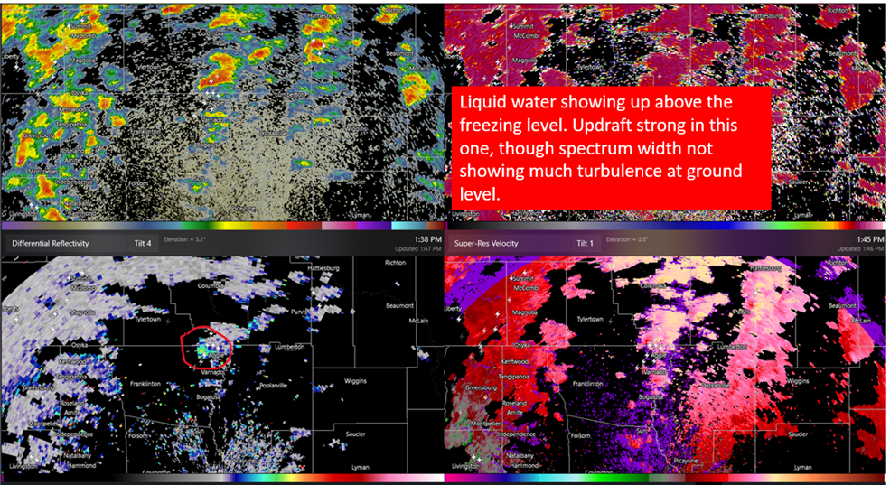
A number of storms running up 59 got a little rotation to em and some turbulence on spectrum width. None of them all that strong of rotation and it's broad but that's going to be my focus for the next little while.

Posted on 3/22/22 at 2:37 pm to 3nOut
quote:
Just got word that my aunt in Granger lost her house entirely. It’s flat. Brand new home they built for retirement.
****Update on this. I got further (more correct) information.****
They did not lose their new (being remodeled) house but it did get pretty beat up. They lost their barniminium right next to it that they lived in while the house was being finished.


This is about 30 minutes from me in Temple or 30 from North Austin.
Posted on 3/22/22 at 2:37 pm to TDsngumbo
maybe - but you are our PoS 

 Page 59 of 94

Popular
Back to top