- My Forums
- Tiger Rant
- LSU Recruiting
- SEC Rant
- Saints Talk
- Pelicans Talk
- More Sports Board
- Fantasy Sports
- Golf Board
- Soccer Board
- O-T Lounge
- Tech Board
- Home/Garden Board
- Outdoor Board
- Health/Fitness Board
- Movie/TV Board
- Book Board
- Music Board
- Political Talk
- Money Talk
- Fark Board
- Gaming Board
- Travel Board
- Food/Drink Board
- Ticket Exchange
- TD Help Board
Customize My Forums- View All Forums
- Show Left Links
- Topic Sort Options
- Trending Topics
- Recent Topics
- Active Topics
Started By
Message

 2
2


Posted on 3/21/22 at 10:51 pm to Lsuhoohoo
hes good just minor dmg.
Posted on 3/21/22 at 10:51 pm to Duke
I’ve been too busy today to post in here but looks like it’s been a busy arse day for weather too, hope everyone is ok
Posted on 3/21/22 at 10:53 pm to Wishnitwas1998
The tornado that went through Gilmer is still on the ground
Posted on 3/21/22 at 10:53 pm to The Boat
Southern storm went Radar Indicated with the new, small warning.
Posted on 3/21/22 at 10:55 pm to The Boat
Am I dumb for going to McComb, MS, tomorrow to storm chase?
Posted on 3/21/22 at 10:55 pm to The Boat
quote:
The tornado that went through Gilmer is still on the ground
Yes it is.
Posted on 3/21/22 at 10:56 pm to The Boat
Good lord.
Posted on 3/21/22 at 10:56 pm to schwartzy
quote:
Am I dumb for going to McComb, MS, tomorrow to storm chase?
Do you have any idea what you're doing?
Cuz chasing the jungle isn't for newbs.
Posted on 3/21/22 at 10:57 pm to schwartzy
quote:
Am I dumb for going to McComb, MS, tomorrow to storm chase?
That is an unanswerable question. We have no idea of your radar or driving abilities. Good luck if you do, but don't if you don't know what you're doing.
Posted on 3/21/22 at 10:57 pm to Duke
Duke cmon explain to use like were 5 here.
Edit: also the 20z HRRR run looks almost exactly whats going on right now which is kinda cool and not cool at the same time
Edit: also the 20z HRRR run looks almost exactly whats going on right now which is kinda cool and not cool at the same time
This post was edited on 3/21/22 at 10:58 pm
Posted on 3/21/22 at 10:58 pm to 50_Tiger
frick tons of low level shear and a good shear profile all the way up.
Tornado machine go brrr with that.
Tornado machine go brrr with that.
Posted on 3/21/22 at 10:58 pm to Duke
quote:
Good lord.
That'll fricking do it. Not what you want to see with that shite sitting off to your West.
Posted on 3/21/22 at 10:59 pm to Duke
I haven't even thought to look at temps and dews out ahead of this.
Posted on 3/21/22 at 11:00 pm to NorthEndZone
quote:
Baseball size hail
LSU just committed another error
Posted on 3/21/22 at 11:00 pm to Duke
That Southern storm is on autopilot. No way I go to bed if I'm on the North side of Shreveport.
Posted on 3/21/22 at 11:01 pm to LegendInMyMind
I have strong knowledge of storms and radar. I lived in Birmingham for years and am used to storms.
I have RadarScope pro, thanks to y’all. Are we expecting a more solid line or can we still expect individual cells in front? A lot of models have more of a consolidated line which would not be worth chasing.
McComb is convenient because if I-55 and is sort of in the heart of the moderate zone
I have RadarScope pro, thanks to y’all. Are we expecting a more solid line or can we still expect individual cells in front? A lot of models have more of a consolidated line which would not be worth chasing.
McComb is convenient because if I-55 and is sort of in the heart of the moderate zone
This post was edited on 3/21/22 at 11:03 pm
Posted on 3/21/22 at 11:02 pm to Duke
Latest mesoscale discussion

quote:
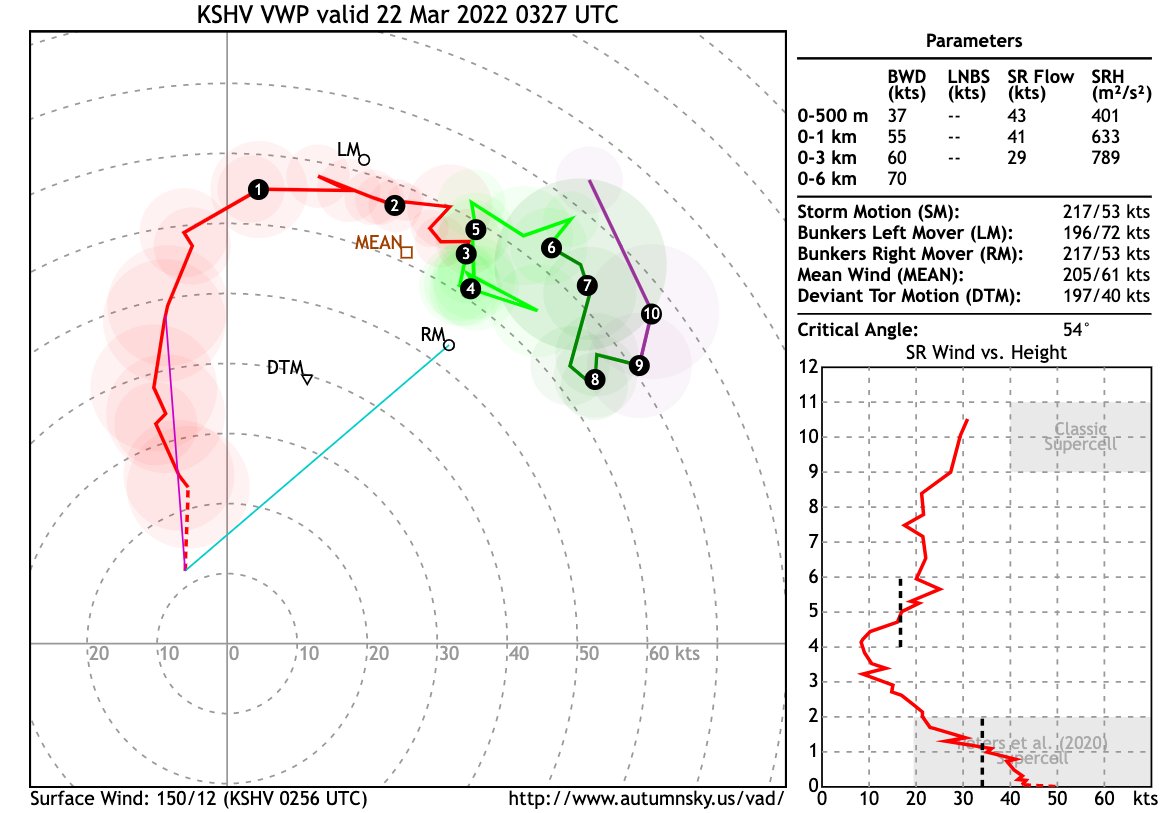
DISCUSSION...Two semi-discrete supercells are ongoing across the Smith/Upshur County Texas area, with another more discrete supercell in progress across Houston County, with either tornadoes reported or TDSs detected via KSHV dual-polarimetric radar in both locations. These storms are progressing in a highly sheared environment, with the SHV depicting an impressive, large/curved hodograph, with over 500 m2/s2 SRH in the 0-1km layer alone. As such, the tornado threat is expected to continue across Tornado Watch 056 for at least a few more hours, as also suggested by the 03Z Warn-on-Forecast ensemble guidance, with several members showing storms remaining discrete and robust into the 05-06Z period.
Posted on 3/21/22 at 11:06 pm to schwartzy
quote:
I have strong knowledge of storms and radar. I lived in Birmingham for years and am used to storms.
My best, serious answer would be to recommend you take a spotter class from your local NWS office. They're free and will help you significantly. You'll also learn how to be a help to the NWS in the field. That would be the best first step. They have two levels of spotter training. Take them both.
Posted on 3/21/22 at 11:06 pm to schwartzy
quote:
I have strong knowledge of storms and radar. I lived in Birmingham for years and am used to storms.
Not inspiring a ton of confidence in me.
quote:
McComb is convenient because if I-55 and is sort of in the heart of the moderate zone
I'd go NE of there. Somewhere on 59 north of Hattiesburg. Gives you the option to go SW if things get firing earlier. High res stuff wants to fire the discrete cells more into central Mississippi tonight. Farther east you get, the better shot to attack them vs getting behind them and trying to catch up. Gives you the best option tree.
But also chasing the jungle is stupid even if you know what you're doing.

 Page 37 of 94

Popular
Back to top