




- My Forums
- Tiger Rant
- LSU Recruiting
- SEC Rant
- Saints Talk
- Pelicans Talk
- More Sports Board
- Fantasy Sports
- Golf Board
- Soccer Board
- O-T Lounge
- Tech Board
- Home/Garden Board
- Outdoor Board
- Health/Fitness Board
- Movie/TV Board
- Book Board
- Music Board
- Political Talk
- Money Talk
- Fark Board
- Gaming Board
- Travel Board
- Food/Drink Board
- Ticket Exchange
- TD Help Board
Customize My Forums- View All Forums
- Show Left Links
- Topic Sort Options
- Trending Topics
- Recent Topics
- Active Topics
Started By
Message
re: Official: Tropical Depression Bill
Posted on 6/15/15 at 7:45 pm to GEAUXmedic


Posted on 6/15/15 at 7:45 pm to GEAUXmedic
63 mph unflagged surface winds found.


 2
2


Posted on 6/15/15 at 8:02 pm to GEAUXmedic
Can anybody give a brief update for people who don't know how to read weather data?
How big is it?
Where is it landing and when?
Category?
How big is it?
Where is it landing and when?
Category?

Posted on 6/15/15 at 8:05 pm to Tiger1242
quote:
How big is it?

quote:
Where is it landing and when?

quote:
Category?
No category. At this point, it's not even a Tropical Storm.
Posted on 6/15/15 at 8:12 pm to RummelTiger
Thank you 
Looks like more rain for me in Dallas, it's like I've moved back to south la these past few months
Looks like more rain for me in Dallas, it's like I've moved back to south la these past few months
Posted on 6/15/15 at 8:14 pm to Tiger1242
We will have Bill shortly:
02L BILL 150616 0000 27.0N 94.0W ATL 45 1005
^ This is the best track, 02 references storm number of the season. It was 91 for invest 91L, now it is 02 for the second storm of the season. 27.0N, 94.0 W are the coordinates. 45 kt winds, 1005 mb pressure, and it is a TS.
note: this isn't official til NHC says so.
02L BILL 150616 0000 27.0N 94.0W ATL 45 1005
^ This is the best track, 02 references storm number of the season. It was 91 for invest 91L, now it is 02 for the second storm of the season. 27.0N, 94.0 W are the coordinates. 45 kt winds, 1005 mb pressure, and it is a TS.
note: this isn't official til NHC says so.
This post was edited on 6/15/15 at 8:37 pm
Posted on 6/15/15 at 8:19 pm to GEAUXmedic

Posted on 6/15/15 at 8:24 pm to GEAUXmedic
quote:
We will have Bill shortly:
AL, 02, 2015061600, , BEST, 0, 270N, 940W, 45, 1005, TS
Just a word of caution, that product has been pulled down in the past. However, this evenings head scratcher does appear to finally be over

Posted on 6/15/15 at 8:27 pm to rds dc
quote:
Just a word of caution, that product has been pulled down in the past. However, this evenings head scratcher does appear to finally be over
Lol, right? As of last year though they stopped sending out the best track too early to prevent that from happening.
Posted on 6/15/15 at 8:54 pm to GEAUXmedic
quote:
Special Message from NHC Issued 16 Jun 2015 01:51 UTC
NHC is initiating advisories on Tropical Storm Bill and expects to release the advisory in the next 20 minutes.
Looks like it's officially official...
Posted on 6/15/15 at 9:24 pm to GEAUXmedic
quote:
Lol, right? As of last year though they stopped sending out the best track too early to prevent that from happening.
I know, but I still wouldn't trust that product 100%.
The system is still somewhat poorly organized with an elongated center and tilted to the south.
The official discussion:
000
WTNT42 KNHC 160210
TCDAT2
TROPICAL STORM BILL DISCUSSION NUMBER 1
NWS NATIONAL HURRICANE CENTER MIAMI FL AL022015
1000 PM CDT MON JUN 15 2015
Data from an Air Force Reserve Hurricane Hunter aircraft and
surface observations indicate that the circulation associated with
the low located in the northwestern Gulf of Mexico has become better
defined since earlier today. While the circulation still appears to
be somewhat elongated, the center is defined enough to consider the
system a tropical cyclone, and advisories are being initiated on
Tropical Storm Bill at this time.
The aircraft data indicate an area of 40-45 kt winds north and
east of the center, and the initial intensity is set to 45 kt for
this advisory. Given the relatively broad nature of the system, the
large radius of maximum winds, and the somewhat ragged convective
pattern, only a little strengthening is expected before the center
reaches the coast tomorrow, and the NHC intensity forecast is close
to the latest SHIPS and LGEM guidance. After landfall Bill is
expected to weaken to a depression after 24 hours, and the low-level
circulation is forecast to dissipate by 48 hours following the GFS
and ECMWF solutions. Note that the global models subsequently show
the low- to mid-level remnants of Bill moving northward and then
northeastward ahead of an upper trough into the southern Plains and
mid-Mississippi Valley.
The initial motion estimate is a relatively uncertain 320/10 given
the recent formation of the center. The primary steering mechanism
is a mid-level anticyclone centered over the southeastern United
States, which should result in Bill moving northwestward toward the
Texas coast in the next 12 hours and then inland over south-central
Texas. The track model guidance is in generally good agreement
through landfall. The NHC track forecast is close to a blend of the
latest model fields from the UKMET, ECMWF, and GFS models and is a
little to the left of the multi-model consensus. It is important
not to focus on the exact track of the center, given the large area
across which heavy rains and tropical storm conditions are expected
to occur.
Given this forecast, a tropical storm warning has been issued for
much of the middle and upper Texas coast. However, the main hazard
associated with Bill and its remnants will be heavy rainfall and
flooding across portions of eastern Texas. Please see products from
your local National Weather Service office for more information on
the flooding hazard.
FORECAST POSITIONS AND MAX WINDS
INIT 16/0300Z 27.1N 94.2W 45 KT 50 MPH
12H 16/1200Z 28.3N 95.8W 50 KT 60 MPH
24H 17/0000Z 29.7N 97.3W 35 KT 40 MPH...INLAND
36H 17/1200Z 31.5N 98.3W 25 KT 30 MPH...INLAND
48H 18/0000Z...DISSIPATED
$$
Forecaster Brennan

Posted on 6/15/15 at 9:27 pm to RummelTiger
RummelTiger - "NW La will likely have some serious flooding issues."
Where are you getting your info? NW La is expecting 1" of rain over the next five days. None of the three local networks or the NWS are predicting river levels to rise to last week's level due to heavier rain in the Red River basin.
Where are you getting your info? NW La is expecting 1" of rain over the next five days. None of the three local networks or the NWS are predicting river levels to rise to last week's level due to heavier rain in the Red River basin.
This post was edited on 6/15/15 at 9:32 pm
Posted on 6/15/15 at 9:30 pm to NorthTiger
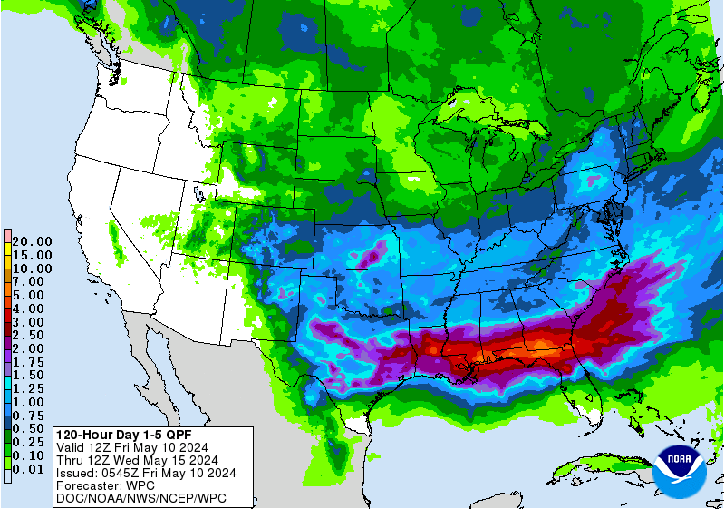
I was basing that off of this:
Posted on 6/15/15 at 9:39 pm to Smoke Green
I reside in Wichita Falls and we are under a Flood Watch for the Red River through Friday night and if we get the rain, to raise the river 2 feet between now and then and we are to be to the west of TS Bill,I don't see how downstream escapes...just my two cents
Posted on 6/15/15 at 9:41 pm to RummelTiger
It looks like most of the 18z models had Bill too far NW by 03z by a good bit, so it will be interesting to see what adjustments are made by the 00z models.
Posted on 6/15/15 at 9:45 pm to wfallstiger
quote:
I reside in Wichita Falls and we are under a Flood Watch for the Red River through Friday night and if we get the rain, to raise the river 2 feet between now and then and we are to be to the west of TS Bill,I don't see how downstream escapes...just my two cents
A wide area under Flood Watches this evening:

Posted on 6/15/15 at 9:45 pm to rds dc

Posted on 6/15/15 at 10:02 pm to NorthTiger
Bossier sheriff had some info on it with their latest pictures. Some chatter from nws about potential for another rapid river rise. Will all depend on what falls and makes it into texoma, hugo, and wright patman. Could be interesting if that 8 - 14" falls across the red river watershed.
Posted on 6/15/15 at 11:02 pm to TigerDog83
Pretty good agreement from the early 00z models that the heaviest rain will stay west of Houston. The Euro runs later tonight and then it will be basically real-time forecasting after that. Good luck to everyone and stay dry


Posted on 6/15/15 at 11:32 pm to RummelTiger
quote:
I was basing that off of this
FWIW, meteorologist here in Kentucky are expecting us to get about a half a foot of rain from the same system once it makes landfall and moves up.
Posted on 6/16/15 at 8:08 am to BluegrassBelle
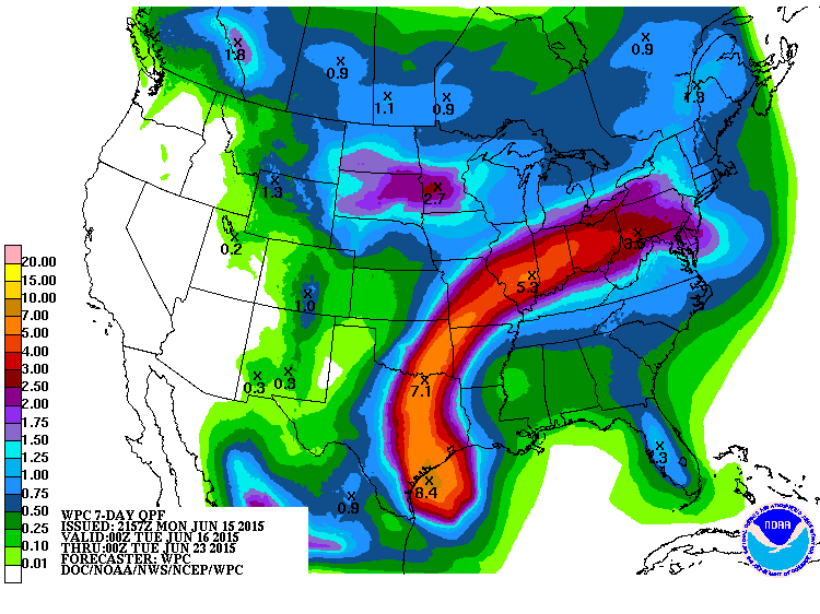
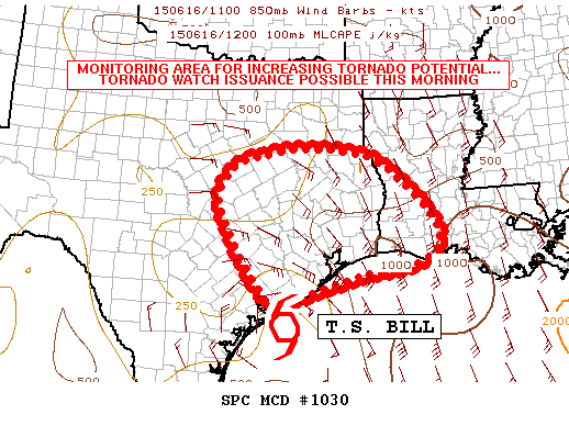
Bill is very near to making landfall and the heavy rain & tornado threat will be increasing across Texas today.

 Page 4 of 8

Popular
Back to top
 Follow TigerDroppings for LSU Football News