- My Forums
- Tiger Rant
- LSU Recruiting
- SEC Rant
- Saints Talk
- Pelicans Talk
- More Sports Board
- Coaching Changes
- Fantasy Sports
- Golf Board
- Soccer Board
- O-T Lounge
- Tech Board
- Home/Garden Board
- Outdoor Board
- Health/Fitness Board
- Movie/TV Board
- Book Board
- Music Board
- Political Talk
- Money Talk
- Fark Board
- Gaming Board
- Travel Board
- Food/Drink Board
- Ticket Exchange
- TD Help Board
Customize My Forums- View All Forums
- Show Left Links
- Topic Sort Options
- Trending Topics
- Recent Topics
- Active Topics
Started By
Message
 1
1


Posted on 3/24/23 at 8:14 pm to Bobby OG Johnson
Continued


Posted on 3/24/23 at 8:16 pm to Bobby OG Johnson
Almost 190 mph gate to gate on that Wedge from Velocity Radar
Posted on 3/24/23 at 8:17 pm to Bobby OG Johnson
quote:
James Spann
@spann
·
11s
The greatest tornado threat in Alabama later tonight will most likely be along and north of I-20. Be sure you have a reliable way of hearing warnings in the middle of the night… Never a siren!
Posted on 3/24/23 at 8:19 pm to Thracken13
Headed south toward isola to get video
Posted on 3/24/23 at 8:19 pm to Bobby OG Johnson
Posted on 3/24/23 at 8:19 pm to Bobby OG Johnson
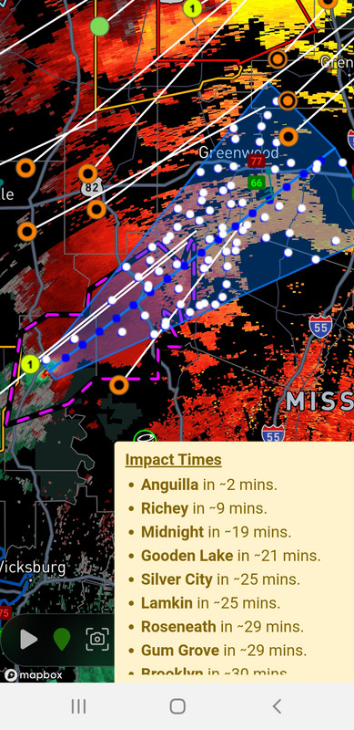
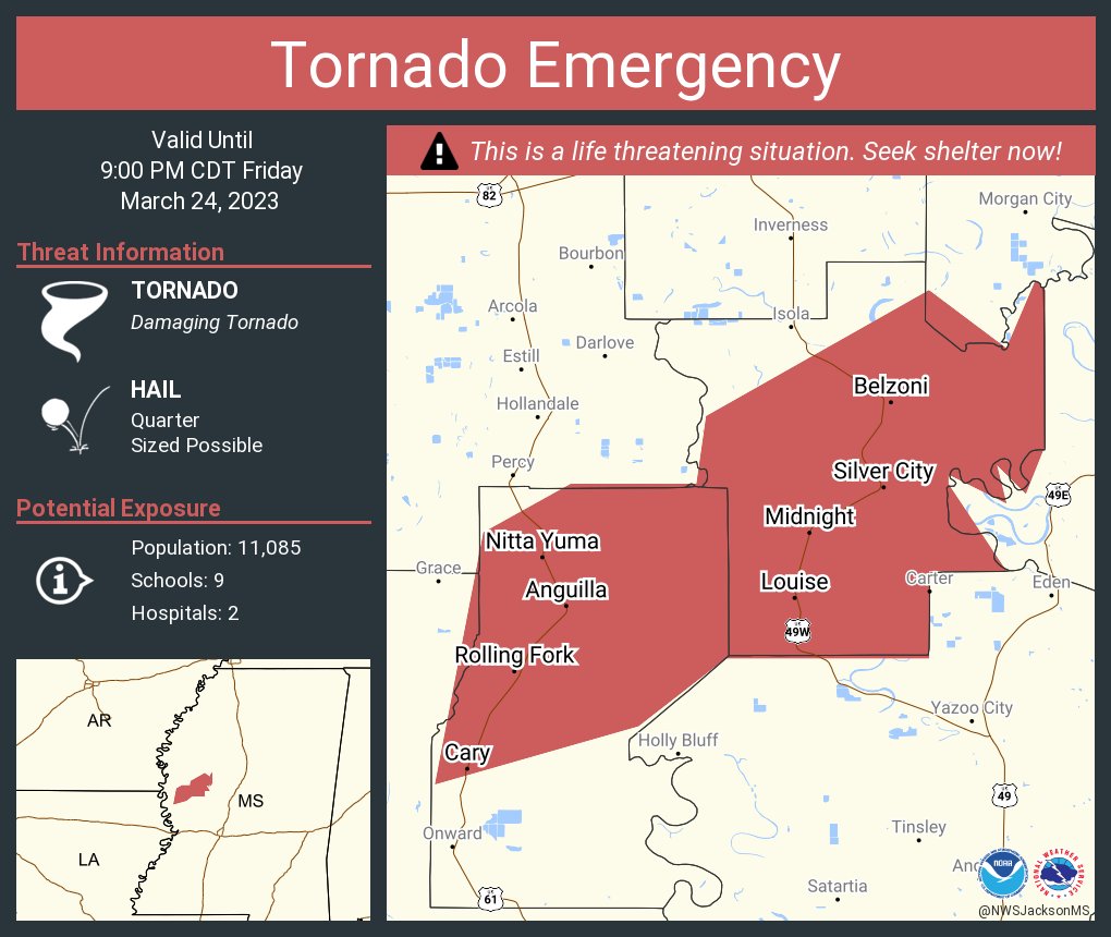
At 815 PM CDT, a confirmed large and destructive tornado was located near Anguilla, or near Rolling Fork, moving northeast at 55 mph.
TORNADO EMERGENCY for Louise, Midnight, and Silver City! This is a PARTICULARLY DANGEROUS SITUATION. TAKE COVER NOW!
HAZARD...Deadly tornado.
SOURCE...Radar confirmed tornado.
IMPACT...You are in a life-threatening situation. Flying debris may be deadly to those caught without shelter. Mobile homes will be destroyed. Considerable damage to homes, businesses, and vehicles is likely and complete destruction is possible.
The tornado will be near... Midnight around 830 PM CDT. Belzoni around 840 PM CDT.
Other locations impacted by this tornadic thunderstorm include Silver City, Cary and Louise.
Posted on 3/24/23 at 8:21 pm to deltaland
quote:
Headed south toward isola to get video
Stay safe
Posted on 3/24/23 at 8:21 pm to tiger91
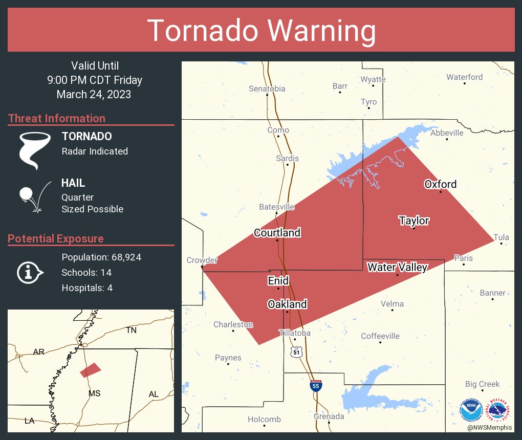
Oxford now in a tornado warning or right on the edge, either way likely will be soon enough
Posted on 3/24/23 at 8:22 pm to Bobby OG Johnson
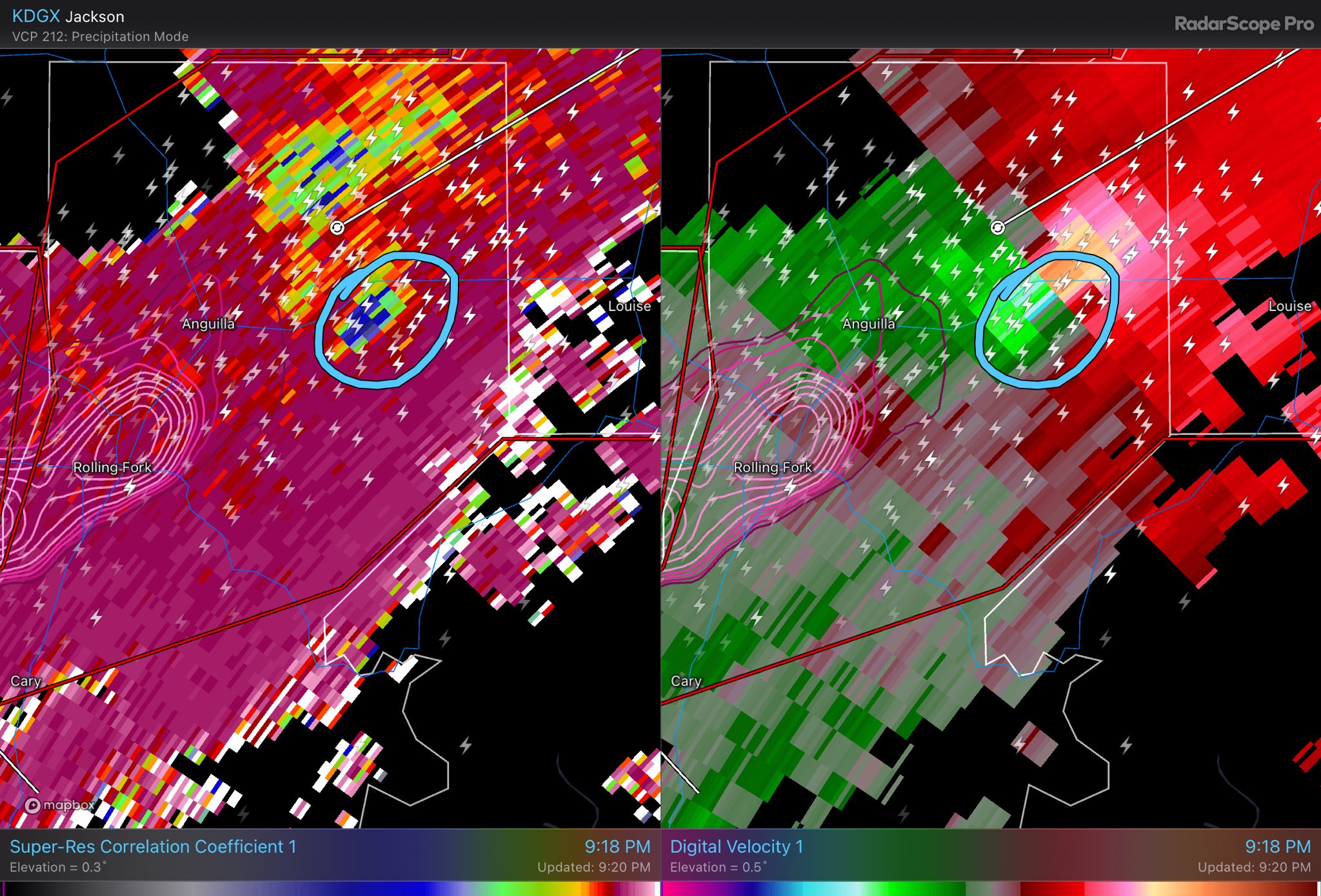
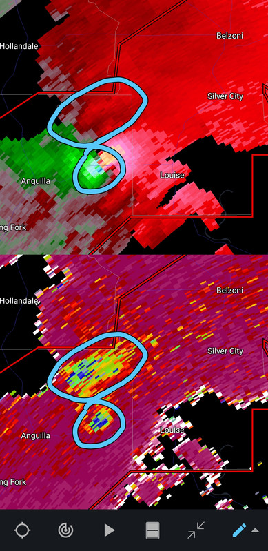
It is cycling out debris quite well on radar right now.
Posted on 3/24/23 at 8:22 pm to Bobby OG Johnson
That's very much not good
Posted on 3/24/23 at 8:22 pm to Bobby OG Johnson
quote:
??Blake Raab - N4BWR??
@N4BWR
·
11s
Debris ball and velocity couplet. This is a large and dangerous tornado on the ground.
Posted on 3/24/23 at 8:23 pm to Bobby OG Johnson
quote:
Texas Storm Chasers
@TxStormChasers
·
6m
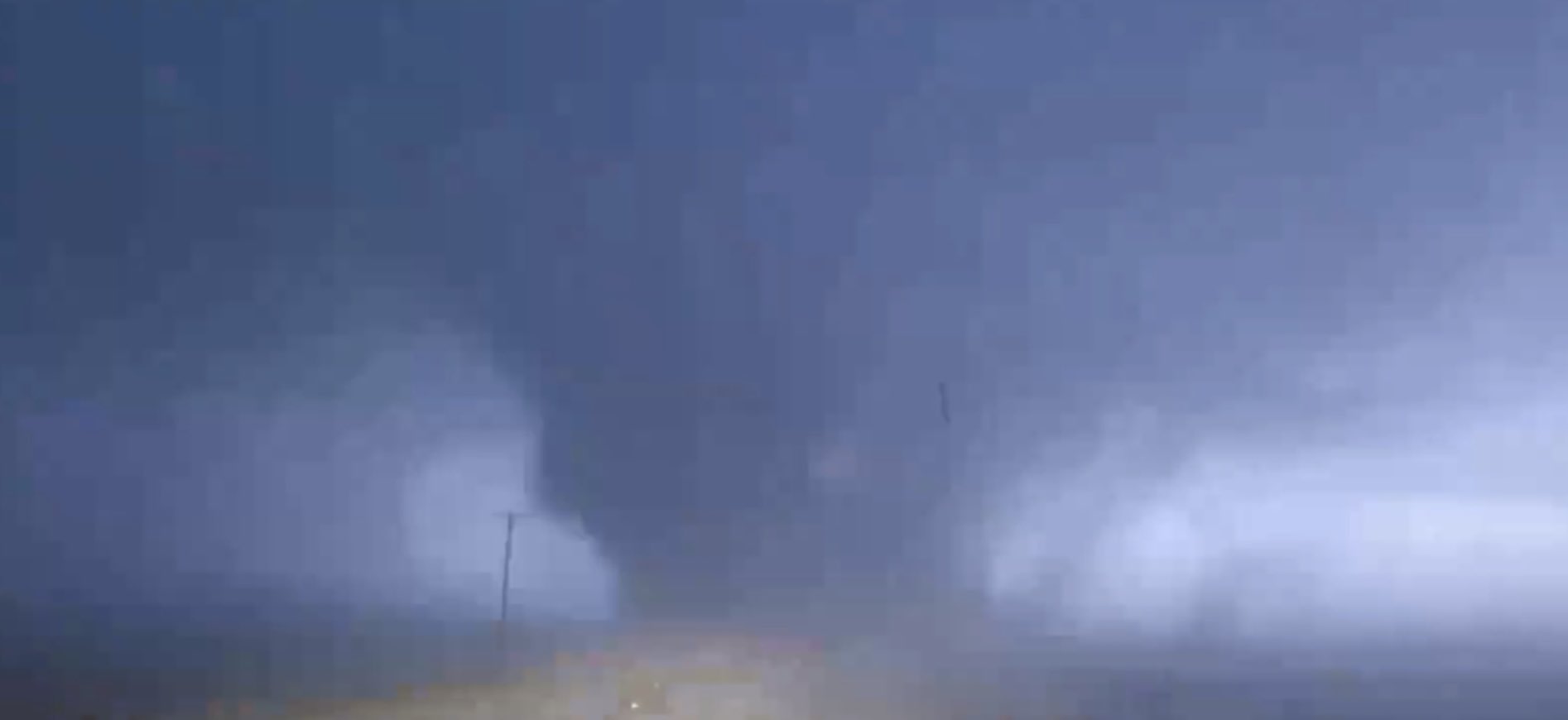
Adam, Ben, and Stephen's view from our live video stream as a violent tornado approached Rolling Fork, MS at about 8:05 PM CT. #mswx @NWSJacksonMS
Posted on 3/24/23 at 8:23 pm to Wishnitwas1998
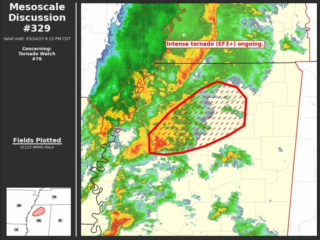
All eyes are on the Wedge but that SCell crossing into AL might be a problem.
Posted on 3/24/23 at 8:24 pm to Wishnitwas1998
Small circle is the TDS. Larger one is lofted debris fallout.
Posted on 3/24/23 at 8:24 pm to Bobby OG Johnson
NWS continued emergency
Posted on 3/24/23 at 8:25 pm to Bobby OG Johnson
Thankfully, Yazoo City is spared on this one

Posted on 3/24/23 at 8:26 pm to Bobby OG Johnson
Meso Strength said 10060 at one point. That’s the highest I’ve ever seen on RadarScope.

 Page 8 of 32

Popular
Back to top