- My Forums
- Tiger Rant
- LSU Recruiting
- SEC Rant
- Saints Talk
- Pelicans Talk
- More Sports Board
- Coaching Changes
- Fantasy Sports
- Golf Board
- Soccer Board
- O-T Lounge
- Tech Board
- Home/Garden Board
- Outdoor Board
- Health/Fitness Board
- Movie/TV Board
- Book Board
- Music Board
- Political Talk
- Money Talk
- Fark Board
- Gaming Board
- Travel Board
- Food/Drink Board
- Ticket Exchange
- TD Help Board
Customize My Forums- View All Forums
- Show Left Links
- Topic Sort Options
- Trending Topics
- Recent Topics
- Active Topics
Started By
Message

 1
1


Posted on 3/26/23 at 4:34 pm to Pedro
Can this severe storm move directly over KALB so i can watch the fricking basketball game
Posted on 3/26/23 at 4:37 pm to S
Im fricking melting
Oh noz a springtime thunderstorm!
fricking soft arse world
Oh noz a springtime thunderstorm!
fricking soft arse world
Posted on 3/26/23 at 4:47 pm to S
You don't have to post in every thread, you know.
Posted on 3/26/23 at 4:50 pm to Sao
Please don’t interrupt my melt

Posted on 3/26/23 at 4:52 pm to S
70 MPH with 2" hail possible

Posted on 3/26/23 at 4:53 pm to Sao
quote:k... keep us posted
You don't have to post in every thread, you know.

Posted on 3/26/23 at 5:02 pm to SuperSaint
This storm near Cheneyville and Bunkie is nasty.

This post was edited on 3/26/23 at 5:02 pm

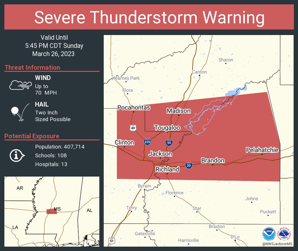
Posted on 3/26/23 at 5:12 pm to Roll Tide Ravens
Pretty impressive rotation on the cell moving straight down I-20 in Jackson
Posted on 3/26/23 at 5:13 pm to Roll Tide Ravens
How is that not tornado warned?
Posted on 3/26/23 at 5:20 pm to deltaland
quote:
How is that not tornado warned?
It's had broad rotation it's whole lifespan but it's been tightening up some. The cell is right in the intersection point of 4 NWS FOs. No one working the radar wants the mark against their verification % if it's going to move out of their coverage area in a few minutes.
Posted on 3/26/23 at 5:22 pm to S
quote:
Can this severe storm move directly over KALB so i can watch the fricking basketball game
Man it's too bad the local news station is fulfilling its government-mandated obligation to keep all residents in its DMA safe

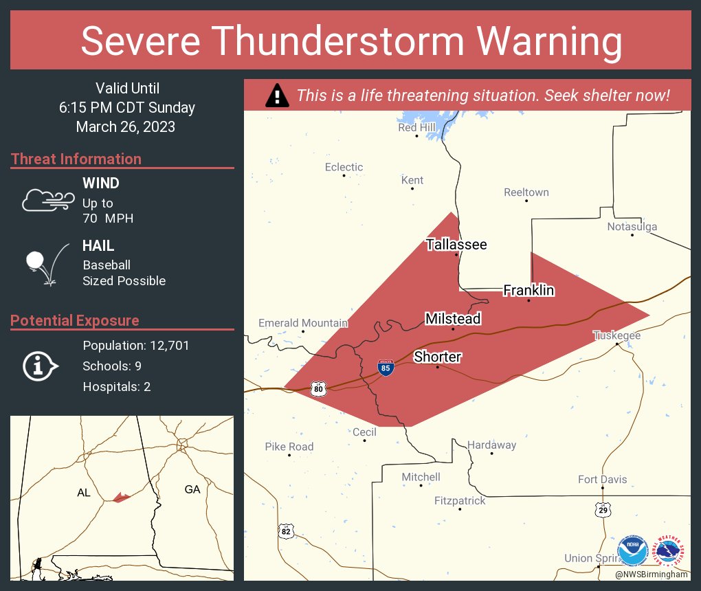
Posted on 3/26/23 at 5:22 pm to The Boat
Getting sloppy in Cottonport!
Posted on 3/26/23 at 5:24 pm to Potchafa
quote:
Getting sloppy in Cottonport!
You would know if it was producing a tornado. Still pretty broad rotation but it tightened up enough to catch a warning.
Posted on 3/26/23 at 5:32 pm to Roll Tide Ravens

Posted on 3/26/23 at 5:43 pm to Roll Tide Ravens
Posted on 3/26/23 at 5:45 pm to The Boat
Getting into the timeframe for the LLJ to start its push.
Posted on 3/26/23 at 5:48 pm to LegendInMyMind
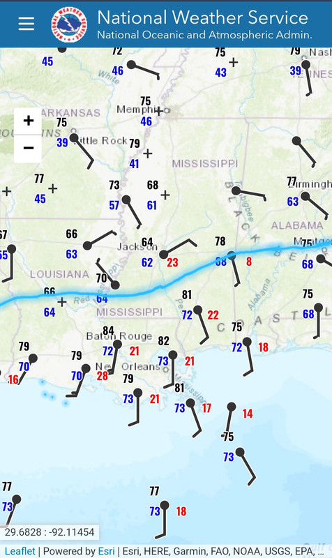
Legend, what is a good way to to see the current position of the warm front?
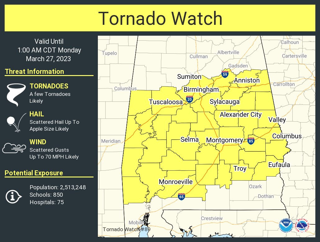
Posted on 3/26/23 at 5:49 pm to Bobby OG Johnson
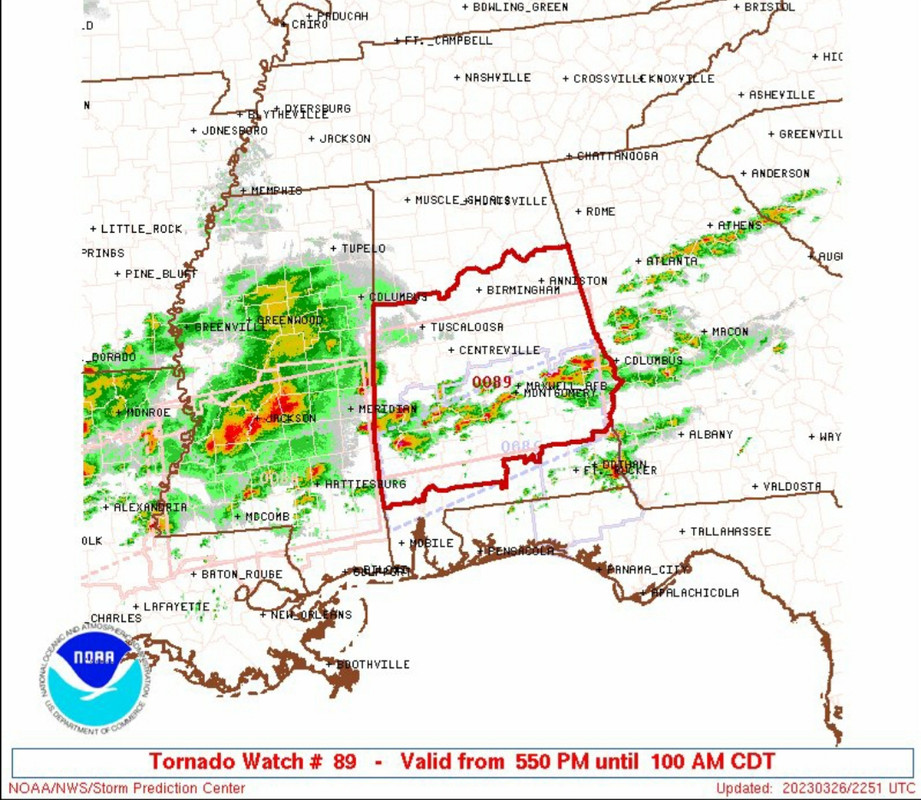
New tornado watch:
This post was edited on 3/26/23 at 5:52 pm
Posted on 3/26/23 at 5:52 pm to Roll Tide Ravens
Pretty clear where the boundary is on surface obs. Anything roughly below the blue line that is discrete and is able to move toward that boundary over the next couple hours will be potential trouble. The LLJ will kick in the next hour or so right over southern MS/AL and help with shear. What rotations we have seen struggle may get a boost going forward.
Hence, the new tornado watch:
ETA: The eastern extent of that front may have drifted a bit farther north than where I drew it looking at the winds again. That is why the Birmingham metro area is in this watch.
Hence, the new tornado watch:
ETA: The eastern extent of that front may have drifted a bit farther north than where I drew it looking at the winds again. That is why the Birmingham metro area is in this watch.
This post was edited on 3/26/23 at 5:58 pm

 Page 28 of 32

Popular
Back to top