- My Forums
- Tiger Rant
- LSU Recruiting
- SEC Rant
- Saints Talk
- Pelicans Talk
- More Sports Board
- Coaching Changes
- Fantasy Sports
- Golf Board
- Soccer Board
- O-T Lounge
- Tech Board
- Home/Garden Board
- Outdoor Board
- Health/Fitness Board
- Movie/TV Board
- Book Board
- Music Board
- Political Talk
- Money Talk
- Fark Board
- Gaming Board
- Travel Board
- Food/Drink Board
- Ticket Exchange
- TD Help Board
Customize My Forums- View All Forums
- Show Left Links
- Topic Sort Options
- Trending Topics
- Recent Topics
- Active Topics
Started By
Message
re: Multi-day Severe Weather Threat: 3/23-3/24
Posted on 3/26/23 at 2:25 pm to LegendInMyMind

Posted on 3/26/23 at 2:25 pm to LegendInMyMind
Two nasty supercells in east Texas
 1
1


Posted on 3/26/23 at 2:25 pm to LegendInMyMind
quote:
Mitt Walker
@mittwalker
Storm that rolled into Montgomery a few minutes ago as viewed from Snowdoun area

Posted on 3/26/23 at 2:28 pm to Bobby OG Johnson
Nice pancake structure for the Deep South.
Posted on 3/26/23 at 2:31 pm to LegendInMyMind
Only a matter of time before the cell moving through Kirbyville produces a tornado
Posted on 3/26/23 at 2:32 pm to LegendInMyMind
quote:
Nice pancake structure for the Deep South.

Posted on 3/26/23 at 2:32 pm to The Boat
The SE AL cell has lost its hail. Looks to be trying to wrap now.
Posted on 3/26/23 at 2:34 pm to The Boat
quote:
Two nasty supercells in east Texas
Should be moving into LA soon/now.
Posted on 3/26/23 at 2:48 pm to LegendInMyMind
Inflow into it is nuts around Bon Wier.
Posted on 3/26/23 at 2:49 pm to LegendInMyMind
Wouldn't want to tbe on Toledo Bend
Posted on 3/26/23 at 2:51 pm to The Boat
The newly warned storm up near Winnsboro may be a problem down the line.
Posted on 3/26/23 at 2:54 pm to The Boat
quote:
Inflow into it is nuts around Bon Wier.
It is on both of the west LA storms, really.

Posted on 3/26/23 at 2:56 pm to LegendInMyMind
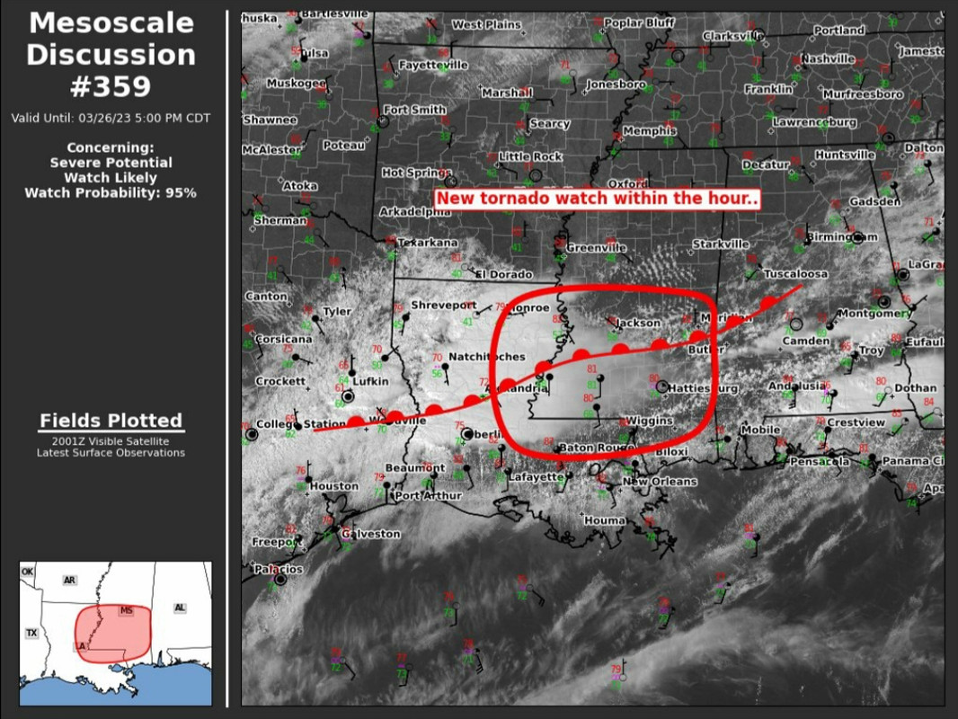
Was not expecting to see a moderate risk today.
Posted on 3/26/23 at 2:57 pm to LegendInMyMind
Size sorting on zdr in the north supercell giving me chubb
This post was edited on 3/26/23 at 2:58 pm
Posted on 3/26/23 at 2:58 pm to Lsuhoohoo
OP needs to add today to the thread title.
Posted on 3/26/23 at 3:01 pm to The Boat
About to get lively in DeRidder. 70mph and ping ball hail.
I'm thinking bigger hail than that at the moment.
I'm thinking bigger hail than that at the moment.
This post was edited on 3/26/23 at 3:04 pm
Posted on 3/26/23 at 3:07 pm to LegendInMyMind
That stuff in north Louisiana gonna track towards me pretty close hopefully it dies out as it moves northeast
Looks nasty
Looks nasty
Posted on 3/26/23 at 3:12 pm to LegendInMyMind
Yeah, the storm approaching DeRidder looks nasty.

This post was edited on 3/26/23 at 3:13 pm

Posted on 3/26/23 at 3:14 pm to Roll Tide Ravens
Where blue meets red, get under the bed.
-Glen Burns
-Glen Burns

 Page 26 of 32

Back to top