- My Forums
- Tiger Rant
- LSU Recruiting
- SEC Rant
- Saints Talk
- Pelicans Talk
- More Sports Board
- Fantasy Sports
- Golf Board
- Soccer Board
- O-T Lounge
- Tech Board
- Home/Garden Board
- Outdoor Board
- Health/Fitness Board
- Movie/TV Board
- Book Board
- Music Board
- Political Talk
- Money Talk
- Fark Board
- Gaming Board
- Travel Board
- Food/Drink Board
- Ticket Exchange
- TD Help Board
Customize My Forums- View All Forums
- Show Left Links
- Topic Sort Options
- Trending Topics
- Recent Topics
- Active Topics
Started By
Message
re: Morganza Spillway may or may not open for a 3rd time -- lack of clear info from ACoE
Posted on 6/6/19 at 5:07 pm to tgrbaitn08
Posted on 6/6/19 at 5:07 pm to tgrbaitn08
quote:
That’s what people want to know why did they change their mind and nothing has changed
Ok I don’t like to engage in rumors but this is one I heard. When they first said it would open, they had reason to believe it would get much higher. Like dangerously high in BR even with it open. They didn’t wanna put that info out and cause panic so they went with the less scary prediction / story for the time being
They had an extra variable into why it would do that but it wasn’t reliable and they wanted to get out ahead of it just in case.
So if anyone wants to jump up and down about what they aren’t saying, assume they didn’t tell the whole story then, not now
This post was edited on 6/6/19 at 5:15 pm
 2
2


Posted on 6/6/19 at 5:14 pm to WeeWee
quote:
It withstood the force of the water in 2011. It has been 8 years since that flood they had plenty of time to make repairs and improvements since then.
quote:
My guess
You can't compare every high river/flood event as the same. Here is why you can't compare 2019 to 2011. In February 2011, the river was extremely low (22.37 ft). It was low enough to be recorded as the 38th lowest river height ever at the Red Landing on 2/25/2011.
Record Low Water marks at the Red River Landing Gauge
Then came the snow melt & spring rains in the lower Mississippi River Valley in April which lead to the record crest of the Mississippi River at the Red River Landing on 5/18/2011 at 63.39 ft.
Record Crest at the Red River Landing gauge
Yes, the Mississippi River reached record heights in the event back in 2011 but it was over a way shorter time period. Fast forward to current time & the river has been above flood stage now at Baton Rouge now a record of 144 days breaking the record of 135 days set during the Great Flood of 1927. The Red River Landing also set a record for being above flood stage. Another record that was set in 1927.
quote:
The Bonnet Carre Spillway is used for the 13th time in its history, and the first time in consecutive years. At peak flow of 213,000 cubic feet per second, a total of 206 gates out of 350 were opened. Baton Rouge went above flood stage of 35.0 feet the morning of Jan 6, 2019. Red River Landing went above flood stage of 48.0 feet on Dec 28, 2018. This is the fourth time the spillway was used in a single decade - the most in its history. On May 10th, and in the first time ever in its history, the Bonnet Carre Spillway was opened once again due do excessive rainfall upriver. On May 21st, Baton Rouge experienced its longest duration flood event, surpassing the 135 days in flood in 1927. On May 28th, Red River Landing surpassed its longest duration flood event established in 1927. [NOTE: Event is still ongoing and information will be updated occasionally until the flood event has ended]
Mississippi River flood history
Now see the entire levee system, spillway system & ORCS designs were engineered to withstand 1927 type, 100 year flooding. The longevity of this flood event & duration of the flood stages along the river is pushing this year's event past 100 year status & into 1000 year status. The entire system has never been tested with this amount of water for this length of time. Every passing day, we are entering unchartered territory in terms of the entire system being pushed to & past it's engineered max.
Posted on 6/6/19 at 5:18 pm to BigBrod81

Posted on 6/6/19 at 5:32 pm to CarRamrod
quote:
so do you know the forcast that is project in the next 30 days upstream of RR landing..... because while you graphs show that it doesnt show the projected forecast. Ever thought that might have changed so the "amount" of water coming down might not be as much.
A drop in the projected crest would indicate a change in the amount of water forecast down stream. That hasn't happened. Like I said, it even shows a slight increase in the forecast from a week ago when the ACOE stated Morganza would need to be opened to prevent it from being overtopped prior to the crest. The crest height hasn't changed yet you mean to tell me that Morganza isn't at risk of being overtopped?
quote:
The opening of the Morganza Control Structure, originally scheduled for Sunday, June 2, has been postponed until June 6. Officials say water levels have fallen enough not to warrant an opening as soon as originally anticipated.
The U.S. Army Corps of Engineers plans to open the Morganza Floodway because forecasts indicate river elevations could overtop the control structure.
The Corps says the river is predicted to reach 60 feet at the control structure June 9 rather than the previously forecasted June 5. The Corps says they only intend to operate the spillway when needed so as to not put additional water into the Atchafalaya Basin.
Chip Kline, Chairman of the Coastal Protection and Restoration Authority, says it’s unlikely that the June 6 opening day will be pushed back any further.
LINK
It's been a bunch of lies & bullshite ever since there was mention of opening Morganza.
And yes that photo does show the forecast a few days in advance or can you just not read? It clearly shows a crest sometime early Saturday June 15th (13 days from now)at 62.2 & holding steady at 62.2 into Wednesday June 19th (17 days from now).
Posted on 6/6/19 at 5:37 pm to X123F45
Posted on 6/6/19 at 5:52 pm to FelicianaTigerfan
quote:
Ok I don’t like to engage in rumors but this is one I heard. When they first said it would open, they had reason to believe it would get much higher. Like dangerously high in BR even with it open. They didn’t wanna put that info out and cause panic so they went with the less scary prediction / story for the time being
They had an extra variable into why it would do that but it wasn’t reliable and they wanted to get out ahead of it just in case.
So something that wasn't in the published river height graphs?
Again, to go back to weather... When the NHC puts out information they put out the discussions. And in them, they will sometimes say, most of the models are in this area, so this is what we are going to go with as far as the forecast, but hey, there's the one model that's an outlier but we can't discount it yet.
Why not more explanation here?
Posted on 6/6/19 at 6:01 pm to FutureMikeVIII
quote:
Are you saying it's not Wilson point or it's not 30 miles b/w the breach and the gage?
Go look at a map of the area. You see all those points and bends in the river and do you see how much land is between the river and the levee? The levees up there are not right next to the river bank like they are in BR and of that is not included in measuring the navigational charts because they are not part of the shipping channel. The google car has never driven down the levee so they do not know the exact distance and they just use a algorithm to calculate it and that algorithm the algorithm says that it 41.4 miles.
quote:
Willow point is down by Eagle Lake.
Wilson Point is a good ways up the river from Eagle Lake. I have had a hunting camp on Pittman Island which is right across the old river from Wilson Point for the past ten years. I saw the results of the '11 flood, the '16 flood the '17 flood and the '18-'19 flood in person. My hunting camp was ten feet off of the ground in '11 and it got 4.5 feet of water inside of it. In addition to having a hunting camp up there, I am from that part of NELA, in high school I worked two years for an ag consultant checking cotton all the way from McGehee Ar to Waterproof La, and I dated a girl for 18 months whose father owns and farms land in the point. I know the area by heart
quote:
It's clear your reading comprehension isnt that great, but you are agreeing with me. There was 1 ft of water overtopping the levee, I was saying that would've filled the bowl with b/w 20 and 26 ft of water, which can then be used to calculate volume.
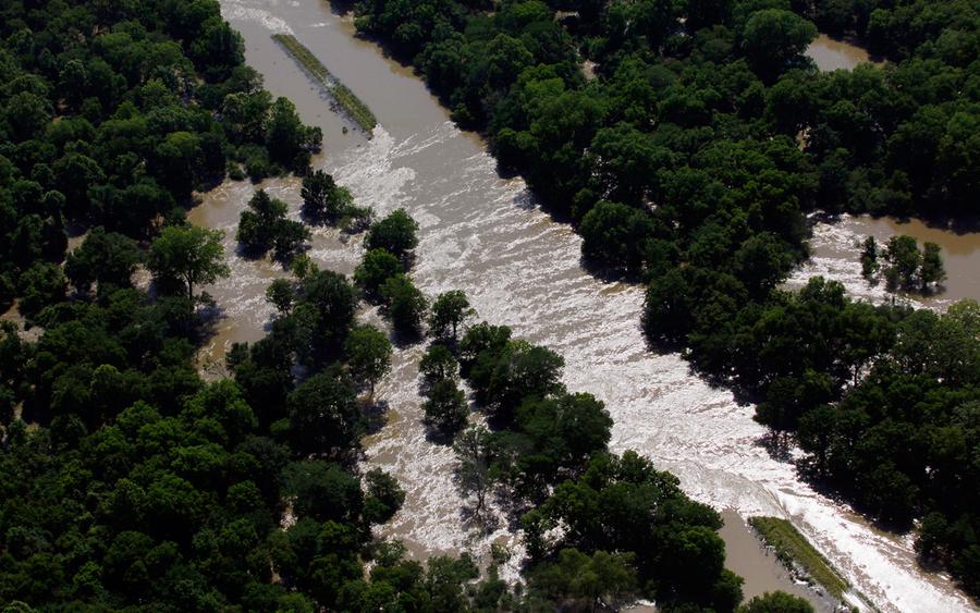
The levee did not just overtop. I saw it moments before it failed. I was there that day. I had been helping the farmers stack sandbags to try and reinforce the levee earlier in the day before they decided that it was pointless, and we started moving equipment out of the point and back to the protected side of the main levee. I did not see the levee overtop because I had just dropped a tractor off, but I was there to see it within 15 minutes of the levee overtopping and by that point it had overtopped and had a hole in about a 20 feet wide and growing by the minute. It ended up being a hole over 90 feet wide and some parts of the point had 30 feet of water. Also Did you see the picture of those houses with the water up to the roof? Those were two story houses.
quote:
There is no evidence to support that claim. BC is designed to protect New Orleans. It may provide very minor relief to a very localized area upstream, but not on the order of even 1 ft all the way up to Baton Rouge.
Simple physics. Opening the BCS gives the Ms river an additional outlet to the GOM. That reduces resistance to the flow of water and resistance and flow are inversely related. The Ms river average discharge is LINK 593,000 cuft/s. If the BCS is opened all the way up and the river would be discharging an additional 250,000 cuft/s of water. Do you really think that adding an additional 42% to the Ms River discharge would not affect the level of the river flow of water in BR? It might not happen at once but if you drain an additional 250,000 cuft/s of water you will eventually decrease the amount of water in BR because you are draining the river faster.
Posted on 6/6/19 at 6:04 pm to BigBrod81
Just heard from a reliable source that the structure is unsound and that led to the decision not to open. They identified issues after the 2011 event, but due to funding and political reasons sat on their hands not making the necessary repairs. They are worried the entire structure will fail if they are forced to open the Morganza. So they are just going to let it ride true Louisiana style...
Posted on 6/6/19 at 6:06 pm to OleWarSkuleAlum
Now the truth comes out.
More lies by the ACOE
More lies by the ACOE
Posted on 6/6/19 at 6:06 pm to OleWarSkuleAlum
quote:
Just heard from a reliable source that the structure is unsound and that led to the decision not to open. They identified issues after the 2011 event, but due to funding and political reasons sat on their hands not making the necessary repairs. They are worried the entire structure will fail if they are forced to open the Morganza. So they are just going to let it ride true Louisiana style...
WOW

Posted on 6/6/19 at 6:07 pm to ike221
quote:
They are worried the entire structure will fail if they are forced to open the Morganza. So they are just going to let it ride true Louisiana style...

This post was edited on 6/6/19 at 6:13 pm
Posted on 6/6/19 at 6:10 pm to OleWarSkuleAlum
quote:
They are worried the entire structure will fail if they are forced to open the Morganza.
Sounds like a perfect way to get the funding to repair it.
Posted on 6/6/19 at 6:14 pm to OleWarSkuleAlum
quote:
Just heard from a reliable source that the structure is unsound and that led to the decision not to open.
Drove over it yesterday. To me, the bumps are worse. Sucks that my daughter lives right by it.

Posted on 6/6/19 at 6:17 pm to OleWarSkuleAlum
So, one coonass with a post hole digger and some ammonium nitrate can change the course of the Mississippi River because they don't want to risk damage to the structure?

Posted on 6/6/19 at 6:20 pm to fishfighter
Now, do you see why the USACE needs to give information out, FelicianaTigerfan?
A few posts up is one hell of a fricking dangerous rumor if it isn't true and spreads and it's one hell of a fricking dangerous rumor if it is true and isn't addressed
Everyone has "reliable sources" and in an information vacuum during stressful and tense situations, they'll believe them, warranted or not.
This post was edited on 6/6/19 at 6:28 pm
Posted on 6/6/19 at 6:32 pm to TigerstuckinMS
quote:
Now, do you see why the USACE needs to give information out, FelicianaTigerfan?
A few posts up is one hell of a fricking dangerous rumor if it isn't true and spreads and it's one hell of a fricking dangerous rumor if it is true and isn't addressed
Idiots are going to make stupid rumors regardless of what gets put out for public consumption. The kind of person that believes that kind of rumor would not be satisfied by some PR statement.
Posted on 6/6/19 at 6:41 pm to LSUFanHouston
quote:
something that wasn't in the published river height graphs?
As told to me, the models that put out projections are just a small portion of what they have. It’s like computer models for hurricanes. Some swing way right and others way left. Or as applied to the river, way up and way down. Well models were trending way up but they aren’t regulated to publish that. The consensus and come of uncertainty graded on a curve is what they have to publish.
Also understand that anything past 5 day forecast is bullsit since they can only forecast with 48 hrs rainfall prediction. So even if it shows rain the next 7 days in Missouri, only 2 days of that it’s in the 5-28 day forcast
Posted on 6/6/19 at 6:49 pm to LNCHBOX
quote:
The river models change constantly. Surely a weather person such as yourself can understand that.
They don't necessarily owe us an explanation of any kind, but this is a unique situation.
You say you're going to open them. Then you back it up. You back it up again. Then you delay it indefinitely. Some people made significant financial decisions based on that data. It damn sure doesn't hurt to explain the logic being used.
Posted on 6/6/19 at 6:52 pm to TigerstuckinMS
Ok so nobody wants to believe COE and the data they put out. But you demand more explanation from them.
And also, a person that buys into doomsday gossip isn’t COE problem. If people wanna gossip and run their mouths fine. Why is that COE problem? Ever been involved with PR? Even if you put out info, people won’t like it and say you’re lying, covering up, etc. It’s not a winnable battle when people are getting their jolly’s by talking about it
And also, a person that buys into doomsday gossip isn’t COE problem. If people wanna gossip and run their mouths fine. Why is that COE problem? Ever been involved with PR? Even if you put out info, people won’t like it and say you’re lying, covering up, etc. It’s not a winnable battle when people are getting their jolly’s by talking about it
Posted on 6/6/19 at 7:00 pm to slackster
quote:
Some people made significant financial decisions based on that data. It damn sure doesn't hurt to explain the logic being used.
This could apply to so many things that I can't take it as a serious argument

 Page 98 of 107

Popular
Back to top