- My Forums
- Tiger Rant
- LSU Recruiting
- SEC Rant
- Saints Talk
- Pelicans Talk
- More Sports Board
- Coaching Changes
- Fantasy Sports
- Golf Board
- Soccer Board
- O-T Lounge
- Tech Board
- Home/Garden Board
- Outdoor Board
- Health/Fitness Board
- Movie/TV Board
- Book Board
- Music Board
- Political Talk
- Money Talk
- Fark Board
- Gaming Board
- Travel Board
- Food/Drink Board
- Ticket Exchange
- TD Help Board
Customize My Forums- View All Forums
- Show Left Links
- Topic Sort Options
- Trending Topics
- Recent Topics
- Active Topics
Started By
Message

 4
4

Posted on 3/17/25 at 7:27 pm to MardiGrasCajun
Where is that from? Tylertown?
Posted on 3/17/25 at 8:18 pm to SidewalkTiger
damn man - sorry t hear that - i truly hope they do not jack you around over it.
Posted on 3/17/25 at 8:21 pm to MardiGrasCajun
damn man - were they home when it hit, and more importantly are they ok?
Posted on 3/17/25 at 8:32 pm to MardiGrasCajun
quote:
My niece’s home….
I hope she and her son are okay and she recovers without issue.
Posted on 3/17/25 at 8:41 pm to MardiGrasCajun
Glad she's okay.
Homes can be rebuilt, lives can't.
Homes can be rebuilt, lives can't.
Posted on 3/17/25 at 9:00 pm to SteelerBravesDawg
The preliminary paths have been added to the DAT, but no damage indicators yet. The paths are the two without markers, the red and orange ones. The other paths are past tornadoes in the area.
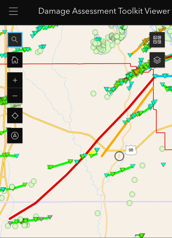
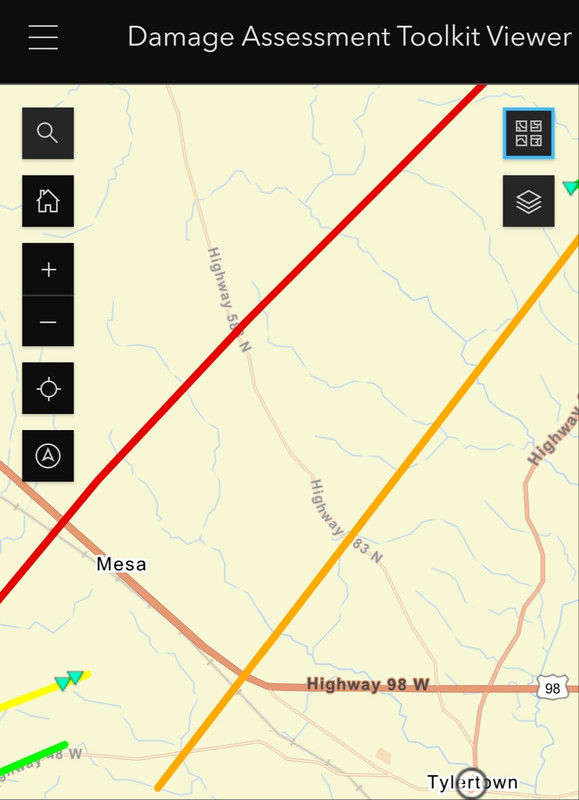
The EF4 tornado (red) crossed paths with two prior tornadoes, and almost a third.
The EF4 tornado (red) crossed paths with two prior tornadoes, and almost a third.
Posted on 3/17/25 at 10:29 pm to schwartzy
quote:
Where is that from? Tylertown?
Yes.

Posted on 3/18/25 at 11:57 am to Roll Tide Ravens
Posted on 3/18/25 at 12:08 pm to Roll Tide Ravens
Posted on 3/18/25 at 12:54 pm to LegendInMyMind
42 people dead and 79 confirmed tornadoes.
“wEaThEr fOrEcAsTiNg Is OuT oF cOnTroL!!!!!”
“wEaThEr fOrEcAsTiNg Is OuT oF cOnTroL!!!!!”

Posted on 3/18/25 at 12:57 pm to Roll Tide Ravens
The rectangular pixels on a nexrad scan, about what does that translate to in land area? I understand high tilt scans probably represent a higher area than a low angle scan. Sorry if this is a stupid question.
Posted on 3/18/25 at 1:18 pm to deeprig9
Posted on 3/18/25 at 1:34 pm to East Coast Band
Posted on 3/18/25 at 5:52 pm to TigerTatorTots
Posted on 3/18/25 at 8:02 pm to Roll Tide Ravens
Posted on 3/18/25 at 9:01 pm to Roll Tide Ravens
Had to travel to Grenada Ms today, There was one that crossed 55 just south of Grenada about 7-8 miles.

Posted on 3/18/25 at 9:14 pm to JimTiger72
Wow that path was pretty ideal to avoid as many expensive neighborhoods as possible
This post was edited on 3/18/25 at 9:15 pm
Posted on 3/19/25 at 11:44 am to Roll Tide Ravens
Posted on 3/19/25 at 11:44 am to Roll Tide Ravens

Missouri about to get just the tip.

 Page 87 of 88

Popular
Back to top