- My Forums
- Tiger Rant
- LSU Recruiting
- SEC Rant
- Saints Talk
- Pelicans Talk
- More Sports Board
- Fantasy Sports
- Golf Board
- Soccer Board
- O-T Lounge
- Tech Board
- Home/Garden Board
- Outdoor Board
- Health/Fitness Board
- Movie/TV Board
- Book Board
- Music Board
- Political Talk
- Money Talk
- Fark Board
- Gaming Board
- Travel Board
- Food/Drink Board
- Ticket Exchange
- TD Help Board
Customize My Forums- View All Forums
- Show Left Links
- Topic Sort Options
- Trending Topics
- Recent Topics
- Active Topics
Started By
Message
 1
1

Posted on 3/14/25 at 1:03 pm to alphaandomega
I haven't watched this morning's video yet, but if anyone wants a high quality breakdown of the nuts and bolts of this setup, you will be hard pressed to find a better one than this. Trey does great work.
This was released this morning prior to the High Risk bump.
This was released this morning prior to the High Risk bump.

Posted on 3/14/25 at 1:03 pm to alphaandomega
Posted on 3/14/25 at 1:04 pm to SteelerBravesDawg
I can only imagine how bad the dust bowl days were. Its insane the wind today!!
Loading Twitter/X Embed...
If tweet fails to load, click here.
Posted on 3/14/25 at 1:06 pm to Thracken13
quote:
gonna get shite locked down out back before tomorrow - I'm about smack in the middle of the High Risk now
In the High as well here and making arrangements to get everyone situated ahead of time and button up anything that I can
Y'all be safe
Posted on 3/14/25 at 1:07 pm to OU Guy
The fire potential out that way today is just scary.
Loading Twitter/X Embed...
If tweet fails to load, click here.
Posted on 3/14/25 at 1:08 pm to slinger1317
quote:
Does everything these days have to be SEVERE WEATHER OUTBREAK
It's going to be thunderstorms with heavy winds, like we have our entire lives
But now every dork on social media thinks he is a weather expert and we get a thread on TD 2 "tracking" this "storm" for 2 weeks. It just fricking normal weather patterns and people act like Katrina is about to hit land
To reiterate:
quote:
This is going to be one of those days where some baws say “this wuz a big miss nothing even happened” because a tornado doesn’t roll directly through their yard, while something 20 miles away gets completely smashed.
Posted on 3/14/25 at 1:08 pm to Bobby OG Johnson
quote:
Y'all be safe
Y'all, too. Praying for everyone, you and yours included, Bobby.
Posted on 3/14/25 at 1:09 pm to Bobby OG Johnson
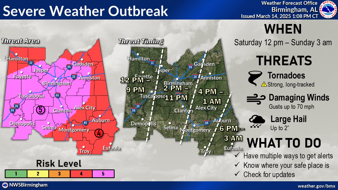
South West of Birmingham right in the 5.
The dumbass coach of my daughters travel ball team signed us up for a tournament in Decatur on Sunday.
Let's travel 2 hours north less than 12 hours after a historical weather event. Complete idiot.
The dumbass coach of my daughters travel ball team signed us up for a tournament in Decatur on Sunday.
Let's travel 2 hours north less than 12 hours after a historical weather event. Complete idiot.
Posted on 3/14/25 at 1:09 pm to East Coast Band
quote:
This is only the 3rd time since at least 2006 (when we can easily query our records), and likely only the 3rd time in SPC history based on available data, that a High Risk has been issued on Day 2.
The 2 previous times were:
4/14/2012
4/7/2006
Note: Apparently not even April 27, 2011
Yeah, saw an interesting stat that each of those events produced 91 and 151 tornadoes. Buckle up and be safe y'all, tonight through Sunday morning is going to be a scary ride for a lot of people.
Posted on 3/14/25 at 1:09 pm to BoogaBear
I'd tell him to frick off

Posted on 3/14/25 at 1:11 pm to AHM21
quote:
Im in the middle of level 5.
Same. Gonna get my storm room/safe place cleaned up this evening and ready to go. Used to be into riding ATVs and I still have my helmet, so I use that if it gets serious enough to require putting on a helmet.
This post was edited on 3/14/25 at 1:12 pm
Posted on 3/14/25 at 1:13 pm to BoogaBear
quote:
The dumbass coach of my daughters travel ball team signed us up for a tournament in Decatur on Sunday.
You’re the adult here. More importantly you’re the parent.
Tell him no.
Posted on 3/14/25 at 1:14 pm to tide06
Posted on 3/14/25 at 1:15 pm to LegendInMyMind
quote:
The fire potential out that way today is just scary.
A lot of dry tinder out there. They’ve been doing a lot of prescribed burns lately, but not nearly enough.
Posted on 3/14/25 at 1:16 pm to tide06
quote:
Meteorologist Nick Mikulas
·
SPC has just upgraded parts of Mississippi and Alabama to a high risk of severe weather on Saturday. The high risk is rarely used, and hasn’t been since May of 2024. We’ve only had 5 instances of a high risk since 2020 including tomorrow’s high risk. Each of the last 3 high risks saw at least one EF4 tornado, and it wouldn’t surprise me at all to see multiple, strong, long tracked tornadoes tomorrow. Heck, it wouldn’t surprise me if we saw multiple long tracked tornadoes across the country today. So yes, it’s going to be a rough couple of days, though I still think the worst of this stays to our north and east. That being said, my thought process has changed a bit on the local impact.
Let’s start with the Friday threat. The HRRR model, and some other high resolution guidance is becoming more insistent that we will see a severe threat in our area this afternoon. The 4:00-9:00 PM timeframe looks like our best chance to see severe storms develop. All modes of severe weather will be possible with any storms that develop. While I’m still uncertain on how many storms may pop, I do know that there will be the potential for significant severe weather with any cells that do fire up. Unfortunately, today’s threat has trended in the wrong direction, and I now think we will have severe weather in the area due to agreement among the short range models that there will be storms. This is especially true for the northern half of Central Louisiana.
Saturday is going to be a nasty day across the Deep South, and while the most intense threat will be to our east, we still stand a chance to see severe weather in the morning and early afternoon. Any storm that develops could quickly become severe, with all modes of severe weather possible. This will quickly exit to the east of our area by around 2:00 PM, but even a brief threat, with severe parameters like this is a dangerous threat. The further west you go in our area, the better your chance to see no severe weather on Saturday. I think west of Highway 165 has a much lower chance than places like St. Landry, Avoyelles, Catahoula, and Concordia Parish. Once this system exits our area, we will see an outbreak of tornadoes across southeast Louisiana, Mississippi, Alabama, and Tennessee. This could be a day those areas will be talking about for a long while.
As many of you know, I am out of town, and going a bit crazy that I’m not there. I’ll say it a million times, I have the best back up in the world in Tom Konvicka, and you are in the best hands for any local severe coverage. All we can do now is be ready to seek shelter, and pray this system ends up underachieving in a big way. I’ll be watching the cameras if we have severe weather in our area later today so I can keep those pointed in the right direction. We will update things as needed.
Posted on 3/14/25 at 1:16 pm to Roll Tide Ravens
In the high risk area tomorrow, there is 30-44% chance of a tornado within 25 miles of a given point.

This post was edited on 3/14/25 at 1:17 pm
Posted on 3/14/25 at 1:18 pm to Roll Tide Ravens
Posted on 3/14/25 at 1:18 pm to SteelerBravesDawg
Everyone stay safe out east!
Posted on 3/14/25 at 1:20 pm to Roll Tide Ravens
That's 1 hell of a hatched area

 Page 5 of 88

Popular
Back to top