- My Forums
- Tiger Rant
- LSU Recruiting
- SEC Rant
- Saints Talk
- Pelicans Talk
- More Sports Board
- Fantasy Sports
- Golf Board
- Soccer Board
- O-T Lounge
- Tech Board
- Home/Garden Board
- Outdoor Board
- Health/Fitness Board
- Movie/TV Board
- Book Board
- Music Board
- Political Talk
- Money Talk
- Fark Board
- Gaming Board
- Travel Board
- Food/Drink Board
- Ticket Exchange
- TD Help Board
Customize My Forums- View All Forums
- Show Left Links
- Topic Sort Options
- Trending Topics
- Recent Topics
- Active Topics
Started By
Message
re: Major Severe Weather Outbreak: March 14-16, 2025
Posted on 3/15/25 at 11:09 am to Bayou_Tiger_225
Posted on 3/15/25 at 11:09 am to Bayou_Tiger_225
My stress level is too high today. I would like spring a whole lot more without days like this.
 2
2

Posted on 3/15/25 at 11:10 am to NEALCD
quote:
Questions for the ones that know. With that storm in lower MS why isn’t anything showing up on coefficient? Velocity looked nasty for a while now. Is that normal for some of these storms?
I don't have a good answer, and I've been pondering it for a little while now. It isn't rare for that to happen, but I feel like it has happened more often since the round of radar upgrades we've had over the past year or so.
Posted on 3/15/25 at 11:12 am to The Boat
quote:
Next tornado forming south of Rolling Fork.
Heading in same area as previous one where Deltaland and the BamaWaterfowl poster are.
quote:
BULLETIN - EAS ACTIVATION REQUESTED
Tornado Warning
National Weather Service Jackson MS
1104 AM CDT Sat Mar 15 2025
The National Weather Service in Jackson has issued a
* Tornado Warning for...
Northwestern Holmes County in central Mississippi...
Southeastern Washington County in northwestern Mississippi...
North central Issaquena County in west central Mississippi...
Humphreys County in central Mississippi...
Northern Sharkey County in west central Mississippi...
* Until noon CDT.
* At 1104 AM CDT, a severe thunderstorm capable of producing a
tornado was located over Rolling Fork, moving northeast at 55 mph.
HAZARD...Tornado.
SOURCE...Radar indicated rotation.
IMPACT...Flying debris will be dangerous to those caught without
shelter. Mobile homes will be damaged or destroyed.
Damage to roofs, windows, and vehicles will occur. Tree
damage is likely.
* This dangerous storm will be near...
Anguilla and Nitta Yuma around 1110 AM CDT.
Delta City around 1115 AM CDT.
Midnight and Murphy around 1120 AM CDT.
Belzoni, Isola, and Silver City around 1130 AM CDT.
Cruger around 1155 AM CDT.
This post was edited on 3/15/25 at 11:14 am

Posted on 3/15/25 at 11:14 am to NorthEndZone
The couplet on the Isola, MS storm seems to have weakened some. Hopefully it’s no longer producing a tornado.

Posted on 3/15/25 at 11:14 am to NorthEndZone

Posted on 3/15/25 at 11:17 am to SouthernHog
quote:
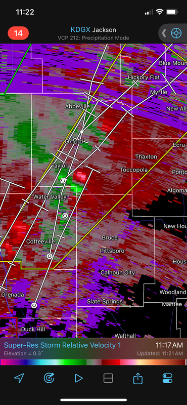
Oxford, MS looks to be in the bullseye
And all the OM kids are on their way back to campus from spring break.
So they’ll drive through storms for hours and their reward at the end will be sitting in the heart of the high risk zone for the day.
Same holds true for Bama which was out this week as well and Tuscaloosa is dead in the middle of the high risk area as well.
Timing for this is rough. If I had kids at either spot they’d be waiting until Sunday to go back.

Posted on 3/15/25 at 11:19 am to MasterAbe1
quote:
They’re off hwy 589 going closer to sumrall so a little ways from you. I actually used to live off Mamie not far from there
Gotcha. I’ll let you know if I hear anything out that way
Posted on 3/15/25 at 11:19 am to Bobby OG Johnson
Any good news? Has the system weakened or is this system still as bad as they predicted? Thanks for any info.
Posted on 3/15/25 at 11:22 am to Hater Bait
They did not issue a new warning on the Oxford line segment.
This post was edited on 3/15/25 at 11:24 am
Posted on 3/15/25 at 11:22 am to Hater Bait
quote:
Any good news? Has the system weakened or is this system still as bad as they predicted? Thanks for any info.
No good news, unfortunately. Everything still looks on track for a significant and potentially violent severe weather outbreak through tonight.
Posted on 3/15/25 at 11:24 am to LegendInMyMind
Why is Oxford, MS not tornado warned?
Posted on 3/15/25 at 11:24 am to Bobby OG Johnson
Good thing about the Mississippi delta it’s pretty rural
Flat and farm land.
So maybe if when they touch down on ground damages will be minimal
Flat and farm land.
So maybe if when they touch down on ground damages will be minimal
Posted on 3/15/25 at 11:24 am to Roll Tide Ravens
Dang it. (Thank you for the update )
Posted on 3/15/25 at 11:24 am to Bobby OG Johnson
Posted on 3/15/25 at 11:27 am to Roll Tide Ravens
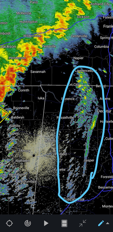
This area has not yet fired any new storms, but it is an area to watch ahead of the line in MS.

Posted on 3/15/25 at 11:31 am to LegendInMyMind
Getting ready for a hard hit here in walker.

Posted on 3/15/25 at 11:32 am to tide06
quote:
Why is Oxford, MS not tornado warned?
The beam you’re using is from Jackson and looking too high up.
Posted on 3/15/25 at 11:34 am to dukke v
I just sat through that cell going through Central. Looks like it may be wrapping up and should be warned soon.

Posted on 3/15/25 at 11:37 am to dukke v
To me it looks like the worst of it is going to be north of us.
Posted on 3/15/25 at 11:42 am to fallguy_1978
What can I expect around Lamar Dixon in Gonzales around 5. Looks like it may be ending. Going to the rodeo

 Page 42 of 88

Popular
Back to top