- My Forums
- Tiger Rant
- LSU Score Board
- LSU Recruiting
- SEC Rant
- SEC Score Board
- Saints Talk
- Pelicans Talk
- More Sports Board
- Coaching Changes
- Fantasy Sports
- Golf Board
- Soccer Board
- O-T Lounge
- Tech Board
- Home/Garden Board
- Outdoor Board
- Health/Fitness Board
- Movie/TV Board
- Book Board
- Music Board
- Political Talk
- Money Talk
- Fark Board
- Gaming Board
- Travel Board
- Food/Drink Board
- Ticket Exchange
- TD Help Board
Customize My Forums- View All Forums
- Show Left Links
- Topic Sort Options
- Trending Topics
- Recent Topics
- Active Topics
Started By
Message
re: Let's Do It Again: Severe Threat 3/30 - Line of Severe Storms leaving SELA. AL in it now
Posted on 3/30/22 at 8:54 pm to Roll Tide Ravens
Posted on 3/30/22 at 8:54 pm to Roll Tide Ravens
 1
1

Posted on 3/30/22 at 8:54 pm to Roll Tide Ravens
Storm in Thomaston looks to have the crosshairs squared on the catfish plant in Uniontown
Posted on 3/30/22 at 8:55 pm to Roll Tide Ravens
quote:
Strange how much rain there is ahead of the line, and how little there is behind it. Sort of the reverse of how it usually is with squall lines.
Just an out and out dumbass guess but maybe the winds were so strong it pushed all the rain more forward than usual?
Posted on 3/30/22 at 8:56 pm to Bobby OG Johnson
Ahhhh makes sense
Posted on 3/30/22 at 8:56 pm to LegendInMyMind
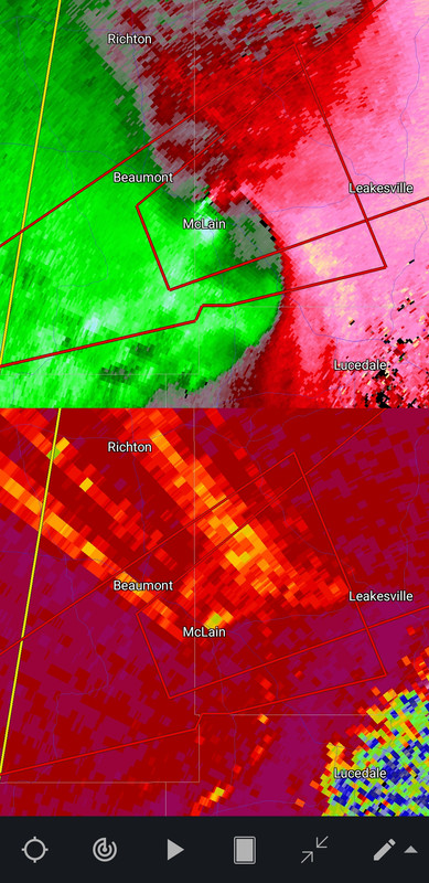
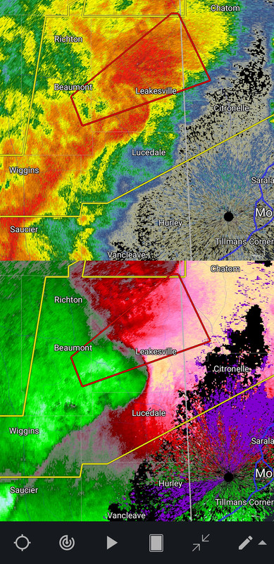
Leakesville is one of the magnets it seems
Posted on 3/30/22 at 8:57 pm to Wishnitwas1998
Looks like just the straight stuff for us, but it's pretty intense.

Posted on 3/30/22 at 8:58 pm to calcotron

Posted on 3/30/22 at 8:59 pm to lsuman25
SUMMARY...A significant tornado threat is materializing across
southeast Mississippi and southwest Alabama.
DISCUSSION...Several mature supercells have emerged from the squall
line across Wayne, Perry, and Greene counties in southeast
Mississippi. The tornadic environment ahead of these storms is
improving substantially with a STP bullseye around 4 near these
storms. Low-level convergence has strengthened considerably in the
vicinity of each of these supercells. Therefore, given storm trends
and the increasingly favorable tornadic environment ahead of these
storms, the strong tornado threat is increasing.
Posted on 3/30/22 at 9:00 pm to Duke
quote:
DISCUSSION...Several mature supercells have emerged from the squall
line across Wayne, Perry, and Greene counties in southeast
Mississippi.
Whelp......that's what we've waited for.

Posted on 3/30/22 at 9:00 pm to Duke
Just checked the spc reports and saw a tornado went through Jackson. Damn.

Posted on 3/30/22 at 9:01 pm to LegendInMyMind
Tornado warnings for Pickens Co., AL both cancelled.
Posted on 3/30/22 at 9:02 pm to Roll Tide Ravens
I’ll be honest, I don’t think we’ll see those 70-80mph gusts with the line tonight. It doesn’t look as strong at the moment. But gusts to 50-60mph are probably still possible.
This post was edited on 3/30/22 at 9:04 pm
Posted on 3/30/22 at 9:03 pm to Pedro
quote:
Just checked the spc reports and saw a tornado went through Jackson. Damn.
Hattiesburg got one, too.
Posted on 3/30/22 at 9:03 pm to Roll Tide Ravens
The line gonna be on top of me in a few minutes. I'll let you know 

Posted on 3/30/22 at 9:04 pm to LegendInMyMind
You know I thought it was odd a couple of days ago when the SPC drew the ending Moderate line specifically falling short just shy of Montgomery, Birmingham and Huntsville. As Im sitting here in north Alabama, I think this prediction is a miss. Hope the fellow Bama boys are ready for a wild night.
Posted on 3/30/22 at 9:04 pm to LegendInMyMind
quote:
Whelp......that's what we've waited for.
That was a pretty damn good call a day or so ago.
Posted on 3/30/22 at 9:05 pm to LegendInMyMind
New tornado warning for Pickens and Tuscaloosa counties in AL.
Posted on 3/30/22 at 9:06 pm to Roll Tide Ravens
that fricker is getting going quick
Posted on 3/30/22 at 9:06 pm to AutoYes_Clown
quote:
You know I thought it was odd a couple of days ago when the SPC drew the ending Moderate line specifically falling short just shy of Montgomery, Birmingham and Huntsville. As Im sitting here in north Alabama, I think this prediction is a miss. Hope the fellow Bama boys are ready for a wild night.
I mean, the most favorable environment currently is in the *(Original) MOD, as evidenced by the MCD Duke posted. The rest is in the Enhanced area. That's the definition of whatever the opposite of Bust is.
ETA: The original MOD
This post was edited on 3/30/22 at 9:11 pm

 Page 74 of 92

Popular
Back to top