- My Forums
- Tiger Rant
- LSU Recruiting
- SEC Rant
- Saints Talk
- Pelicans Talk
- More Sports Board
- Coaching Changes
- Fantasy Sports
- Golf Board
- Soccer Board
- O-T Lounge
- Tech Board
- Home/Garden Board
- Outdoor Board
- Health/Fitness Board
- Movie/TV Board
- Book Board
- Music Board
- Political Talk
- Money Talk
- Fark Board
- Gaming Board
- Travel Board
- Food/Drink Board
- Ticket Exchange
- TD Help Board
Customize My Forums- View All Forums
- Show Left Links
- Topic Sort Options
- Trending Topics
- Recent Topics
- Active Topics
Started By
Message


 1
1


Posted on 3/29/22 at 1:53 pm to paperwasp
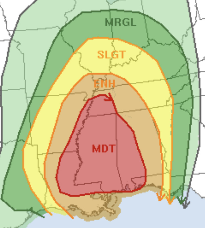
The entire state of Mississippi in a moderate zone.. yeesh
Posted on 3/29/22 at 1:58 pm to Duke
Thanks Duke ... just texted our youngest to be aware of the possibility in North Mississippi.
Posted on 3/29/22 at 2:13 pm to tiger91
Who Tha hell did Mississippi piss off?
Posted on 3/29/22 at 2:13 pm to Roll Tide Ravens
Basically a triangle from Alexandria to Memphis to Pensacola. Good luck, Mississippi!
Posted on 3/29/22 at 2:18 pm to Hulkklogan
quote:
The entire state of Mississippi in a moderate zone
Pearlington says hi
Posted on 3/29/22 at 2:27 pm to RockChalkTiger
Notables from short research I just did of large moderates - these aren't all of them just some I found quickly
4/18/2013 - 120,925 sq. mi.
4/27/2014 - 119,987 sq. mi.
*Day 2 today* - 107,285 sq. mi.
4/18/2013 - 120,925 sq. mi.
4/27/2014 - 119,987 sq. mi.
*Day 2 today* - 107,285 sq. mi.
Posted on 3/29/22 at 3:12 pm to trussthetruzz
NWS New Orleans - High Wind Warning
This is for south of I10 and south of the Lake. Greater BR not included and Northshore not included.
This is for south of I10 and south of the Lake. Greater BR not included and Northshore not included.
quote:
URGENT - WEATHER MESSAGE National Weather Service New Orleans LA 305 PM CDT Tue Mar 29 2022 LAZ056>061-063>070-077-078-300415- /O.UPG.KLIX.WI.Y.0008.220330T1300Z-220331T0200Z/ /O.NEW.KLIX.HW.W.0001.220330T1300Z-220331T0200Z/ Assumption-St. James-St. John The Baptist-Upper Lafourche- St. Charles-Upper Jefferson-Upper Plaquemines-Upper St. Bernard- Upper Terrebonne-Lower Terrebonne-Lower Lafourche-Lower Jefferson- Lower Plaquemines-Lower St. Bernard-Western Orleans- Eastern Orleans- Including the cities of Pierre Part, Labadieville, Paincourtville, Convent, Lutcher, Gramercy, Laplace, Reserve, Thibodaux, Raceland, Larose, Destrehan, Norco, Metairie, Kenner, Belle Chasse, Chalmette, Violet, Houma, Bayou Cane, Chauvin, Cocodrie, Dulac, Montegut, Galliano, Cut Off, Golden Meadow, Leeville, Grand Isle, Buras, Pointe A La Hache, Port Sulphur, Boothville, Venice, Empire, Myrtle Grove, Yscloskey, New Orleans, and East New Orleans 305 PM CDT Tue Mar 29 2022 ...HIGH WIND WARNING IN EFFECT FROM 8 AM TO 9 PM CDT WEDNESDAY... * WHAT...South winds 30 to 40 mph with gusts up to 50 mph expected. * WHERE...Portions of southeast Louisiana. * WHEN...From 8 AM to 9 PM CDT Wednesday. * IMPACTS...Damaging winds will blow down trees and power lines. Power outages are expected. Travel will be difficult, especially for high profile vehicles. * ADDITIONAL DETAILS...Strongest winds are likely to be just in advance of thunderstorms Wednesday afternoon. PRECAUTIONARY/PREPAREDNESS ACTIONS... People should avoid being outside in forested areas and around trees and branches. If possible, remain in the lower levels of your home during the windstorm, and avoid windows. Use caution if you must drive.
Posted on 3/29/22 at 3:15 pm to Duke
Rapides Parish cancelled school for tomorrow.
Posted on 3/29/22 at 3:16 pm to Duke
This is probably up because of Ida recovery and the tornado recovery the other night given the region selected as there isnt a reason the winds would be significantly higher here vs BR or Northshore.
Posted on 3/29/22 at 3:18 pm to Duke
After the ice storm and ida there isn’t much left to fall in BR. Although southdowns and highland say hold my beer.
Posted on 3/29/22 at 3:18 pm to LSUGrrrl
quote:
DFW still looking scary overnight? Alerts tell me hail, damaging winds and tornadoes but hoping the timing knocks at least the tornadoes out while we are sleeping.
Unfortunately, for your area and a bit West, the parameters will maximize into the late night/early morning. That is why there is only a Slight Risk back in Oklahoma. Don't get lulled by placement of the risk level. You're caught in the time gap between days.
Posted on 3/29/22 at 3:21 pm to paperwasp
quote:
Nailed it, Legend.
The NAM has gone ham on that area. There is an advancing line, and then it just turns it into a bunch of cells. If there's enough room for them to breathe, look out.
ETA: And at first glance, the 18z still favors the same development.
This post was edited on 3/29/22 at 3:24 pm
Posted on 3/29/22 at 3:31 pm to LegendInMyMind
One try on the state line SE of Meridian:
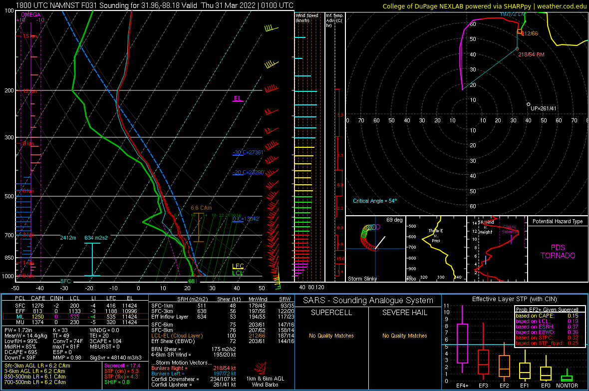
Not much you can pick apart with that one. That SRH....
Not much you can pick apart with that one. That SRH....
Posted on 3/29/22 at 3:35 pm to LegendInMyMind
And we're universally seeing models build temps into the low 80s and dews into the low to mid 60s in advance of those cells. NAM is a bit higher on dews with ~65 average for the area.
Posted on 3/29/22 at 3:38 pm to LegendInMyMind
@NWSHuntsville
quote:
3:30pm Severe Weather Expected Tomorrow
All of the TN Valley
Line of storms could produce widespread damaging winds up to 70-80mph, tornadoes possible Wed Aftn - Wed Night
Wind Advisory: Wed for gusts up to 50mph
Prepare now & Stay updated
#HUNwx LINK
Posted on 3/29/22 at 3:39 pm to LegendInMyMind
Im in agreement of not liking how that SE Miss/SW Ala area is evolving on the models.
Posted on 3/29/22 at 3:41 pm to Duke
Let's go chase, baw. We'll stream it to the OT.
I kid....I wouldn't chase this down there followed by that line. Nope.
I kid....I wouldn't chase this down there followed by that line. Nope.
Posted on 3/29/22 at 3:43 pm to LegendInMyMind
Look at those storm motions too.
54 kts on a right mover. Thats fun.
54 kts on a right mover. Thats fun.

Posted on 3/29/22 at 3:45 pm to LegendInMyMind
James Spann's afternoon update for central AL:
quote:
SIGNIFICANT SEVERE WEATHER THREAT TOMORROW NIGHT: The weather is dry across Alabama this afternoon with a partly sunny sky... temperatures are mostly in the 75-83 degree range. The sky will stay mostly fair tonight with a low in the 50s, but eyes will be to the west, where storms will form in a zone from Texas to Iowa ahead of a dynamic storm system that will bring potential for a significant wind event to the state tomorrow night.
This weather system has very strong wind fields, which will overcome limited instability to create a severe weather threat to the Deep South. SPC has expanded the "moderate risk" (level 4/5) to include areas west of a line from Florence to Birmingham to Greenville to Andalusia. The rest of the state is in an "enhanced risk" (level 3/5).
TIMING: A line of severe storms will likely push into the northwest corner of the state around 6-7 p.m. tomorrow... it will be near I-59 (Gadsden/Birmingham/Tuscaloosa) by around 11 p.m... and then it moves into the rest of East Alabama after midnight.
THREATS: There is potential for relatively widespread wind damage with the line of storms as it passes through, with winds possibly gusting to 65 mph or higher in many places. Also, a few tornadoes could spin up within the line. Some hail is possible, but that isn't a major threat with this type of system.
GRADIENT WIND: It is important to note that gradient winds (not related to thunderstorms) tomorrow afternoon and evening could gust as high as 40/50 mph. This in itself will bring potential for some downed trees and power outages.
RAIN: Rain amounts of 1-2 inches are likely for most places, and some flooding issues are possible. We don't expect as much rain as we experienced last week, however (some places saw up to 5 inches of rain with that event).
CALL TO ACTION: This has potential to be a high end wind event for much of Alabama; plan for power outages. Secure loose objects that might go flying away with strong winds. Pay close attention to severe thunderstorm warnings tomorrow night; if you live in a mobile home I would consider treating a severe thunderstorm warning like a tornado warning and be in a community shelter or business that is open and available as a shelter.
Be sure you have two reliable ways of hearing warnings (NEVER a siren)... a NOAA Weather Radio and your phone; and be sure emergency alerts are enabled on your phone. Have the free ABC 33/40 weather app installed.
The sky will clear during the day Thursday as dry air returns to the state; the high Thursday will be around 70 degrees.
This post was edited on 3/29/22 at 3:46 pm

 Page 11 of 92

Popular
Back to top