- My Forums
- Tiger Rant
- LSU Recruiting
- SEC Rant
- Saints Talk
- Pelicans Talk
- More Sports Board
- Fantasy Sports
- Golf Board
- Soccer Board
- O-T Lounge
- Tech Board
- Home/Garden Board
- Outdoor Board
- Health/Fitness Board
- Movie/TV Board
- Book Board
- Music Board
- Political Talk
- Money Talk
- Fark Board
- Gaming Board
- Travel Board
- Food/Drink Board
- Ticket Exchange
- TD Help Board
Customize My Forums- View All Forums
- Show Left Links
- Topic Sort Options
- Trending Topics
- Recent Topics
- Active Topics
Started By
Message
re: Laura - President Trump visits Lake Charles, Louisiana for Hurricane Response Update
Posted on 8/22/20 at 4:11 pm to GEAUXmedic
Posted on 8/22/20 at 4:11 pm to GEAUXmedic
This is insane
 0
0


Posted on 8/22/20 at 4:11 pm to biohzrd
"You can't have two #1's, that would make 11." - Ricky Bobby
Posted on 8/22/20 at 4:11 pm to rt3
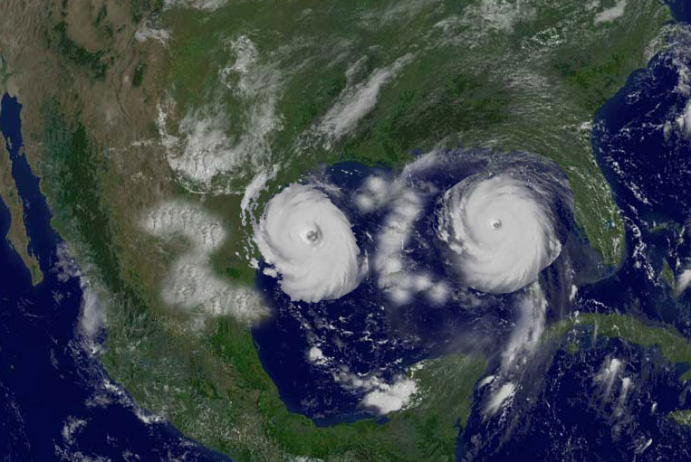
Marco discussion
quote:
Cutting to the chase, there have been some big changes among the
model guidance, and subsequently the NHC forecast, for Marco this
afternoon. While at this point it's a little speculative, the data
collected by this morning's NOAA G-IV flight in the environment
around Marco and across the Gulf of Mexico may have played a key
role in the significant eastward shift seen in nearly all the 12z
models. This isn't to say that the uncertainty in the eventual
track has diminished. In fact, various ensemble members from some
of the global models still show a potential risk to the coast
anywhere from Texas to Alabama, and it's entirely possible that the
volatile shifts seen in the models could continue. That being
said, the new NHC track forecast has been shifted significantly
eastward and now shows the center of Marco reaching southeastern
Louisiana in about 2 days, which is the scenario currently shown by
the GFS, ECMWF, HCCA, Florida State Superensemble, and the TVCN
multi-model consensus. After Marco reaches the coast, the western
Atlantic ridge is expected to build westward and should cause the
cyclone to move more slowly toward the west-northwest across
southern portions of Louisiana.
Posted on 8/22/20 at 4:11 pm to rds dc
The only good news for me at this point is that neither storm appear to be more than cat 1
Posted on 8/22/20 at 4:11 pm to rt3
Louisiana’s about to get rocked

Posted on 8/22/20 at 4:13 pm to GEAUXmedic

Posted on 8/22/20 at 4:13 pm to tiger91
quote:
Ok forgot that they drop dropsondes (sp?). Was thinking that they would still fly through it to collect info.
plus do you want to put a plane in a high turbulence situation potentially right above people's homes?
Posted on 8/22/20 at 4:13 pm to JS87
Posted on 8/22/20 at 4:13 pm to GEAUXmedic
(no message)
This post was edited on 10/18/21 at 3:41 pm
Posted on 8/22/20 at 4:14 pm to JS87
How sure can we be that they both will stay at Cat 1?

Posted on 8/22/20 at 4:14 pm to WestSideTiger
I see the leprechaun
Posted on 8/22/20 at 4:14 pm to rt3
That’s why I ask questions — never even thought about that.
Thanks.
Now, anyone want to tell me their thoughts on this thing/these things and potential to go farther west???
Thanks.
Now, anyone want to tell me their thoughts on this thing/these things and potential to go farther west???
Posted on 8/22/20 at 4:14 pm to Champagne
quote:
How sure can we be that they both will stay at Cat 1?
0%
esp. Laura

Posted on 8/22/20 at 4:15 pm to Champagne

Posted on 8/22/20 at 4:16 pm to NewIberiaHaircut
Posted on 8/22/20 at 4:16 pm to Champagne
quote:
How sure can we be that they both will stay at Cat 1?
Not with that much open hot water.
It’ll most definitely strengthen.

Posted on 8/22/20 at 4:17 pm to rds dc
I hope NOLA has the pumps ready to go.
Posted on 8/22/20 at 4:17 pm to tiger91
quote:
Now, anyone want to tell me their thoughts on this thing/these things and potential to go farther west???
if you want Laura to go into Texas... hope the centers of circulation stack up on the south side of the islands
ETA: for Marco... there may be too much shear for it to fight starting tomorrow for it to develop much more than a 1
This post was edited on 8/22/20 at 4:19 pm

Posted on 8/22/20 at 4:17 pm to geauxtigers87
quote:
What frick is going on
Simple


Posted on 8/22/20 at 4:18 pm to LSUAlum2001
Wtf? What a huge change for Marco from this morning. It aint looking for Louisiana. We bout to get 2 back to back....

 Page 102 of 815

Popular
Back to top