- My Forums
- Tiger Rant
- LSU Recruiting
- SEC Rant
- Saints Talk
- Pelicans Talk
- More Sports Board
- Fantasy Sports
- Golf Board
- Soccer Board
- O-T Lounge
- Tech Board
- Home/Garden Board
- Outdoor Board
- Health/Fitness Board
- Movie/TV Board
- Book Board
- Music Board
- Political Talk
- Money Talk
- Fark Board
- Gaming Board
- Travel Board
- Food/Drink Board
- Ticket Exchange
- TD Help Board
Customize My Forums- View All Forums
- Show Left Links
- Topic Sort Options
- Trending Topics
- Recent Topics
- Active Topics
Started By
Message

 0
0

Posted on 9/28/22 at 5:36 am to Wolfhound45
ABC Tampa just said you and Lanier will get 87 gusts, and I will get 103.  Y'all are way closer to the beast.
Geography, and whatnot.
Geography, and whatnot.

Posted on 9/28/22 at 5:37 am to Hangit
Prayers for all of y’all affected. Stay safe.
Posted on 9/28/22 at 5:38 am to NorthEndZone
Seas are so turbulent that water temp dropped more than 2 degrees. Probably stirring up water from 100 feet down.
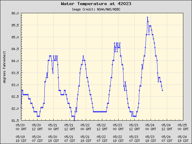
This post was edited on 9/28/22 at 5:39 am
Posted on 9/28/22 at 5:38 am to RummelTiger
6:35 AM EDT Wed Sep 28
Location: 25.9°N 82.8°W
Moving: NNE at 10 mph
Min pressure: 936 mb
Max sustained: 155 mph
Location: 25.9°N 82.8°W
Moving: NNE at 10 mph
Min pressure: 936 mb
Max sustained: 155 mph
Posted on 9/28/22 at 5:39 am to lsuman25
Holy shite

Posted on 9/28/22 at 5:40 am to RummelTiger
quote:
Now cat 4 with 140…possibly higher.
Wow. This storm has been something to watch over the past 24 hours. Any updated info on storm surges? That thing has to be bulldozing walls of water.

Posted on 9/28/22 at 5:40 am to lsuman25
New update from NHC. Winds up to 155mph. Y’all, this is wild. 1 more mph and it’ll be a Cat. 5.
Hurricane Ian Tropical Cyclone Update
NWS National Hurricane Center Miami FL AL092022
635 AM EDT Wed Sep 28 2022
...IAN RAPIDLY INTENSIFYING...
...CONDITIONS RAPIDLY DETERIORATING ALONG THE SOUTHWEST FLORIDA
COAST...
Recent data from a NOAA Hurricane Hunter aircraft indicate
that maximum sustained winds have increased to near 155 mph (250
km/h). A special advisory will be issued by 7 AM EDT (1100 UTC) to
reflect this change and update the forecast.
SUMMARY OF 635 AM EDT...1035 UTC...INFORMATION
----------------------------------------------
LOCATION...25.9N 82.8W
ABOUT 65 MI...105 KM WSW OF NAPLES FLORIDA
ABOUT 80 MI...130 KM SSW OF PUNTA GORDA FLORIDA
MAXIMUM SUSTAINED WINDS...155 MPH...250 KM/H
PRESENT MOVEMENT...NNE OR 15 DEGREES AT 10 MPH...17 KM/H
MINIMUM CENTRAL PRESSURE...936 MB...27.73 INCHES
$$
Forecaster Papin/Blake
Posted on 9/28/22 at 5:41 am to lsuman25
quote:
Max sustained: 155 mph
NHC went with strongest 4 possible.
It's as close to a 5 as it gets...
quote:
617
WTNT64 KNHC 281036
TCUAT4
Hurricane Ian Tropical Cyclone Update
NWS National Hurricane Center Miami FL AL092022
635 AM EDT Wed Sep 28 2022
...IAN RAPIDLY INTENSIFYING...
...CONDITIONS RAPIDLY DETERIORATING ALONG THE SOUTHWEST FLORIDA
COAST...
Recent data from a NOAA Hurricane Hunter aircraft indicate
that maximum sustained winds have increased to near 155 mph (250
km/h). A special advisory will be issued by 7 AM EDT (1100 UTC) to
reflect this change and update the forecast.
SUMMARY OF 635 AM EDT...1035 UTC...INFORMATION
----------------------------------------------
LOCATION...25.9N 82.8W
ABOUT 65 MI...105 KM WSW OF NAPLES FLORIDA
ABOUT 80 MI...130 KM SSW OF PUNTA GORDA FLORIDA
MAXIMUM SUSTAINED WINDS...155 MPH...250 KM/H
PRESENT MOVEMENT...NNE OR 15 DEGREES AT 10 MPH...17 KM/H
MINIMUM CENTRAL PRESSURE...936 MB...27.73 INCHES
$$
Forecaster Papin/Blake

Posted on 9/28/22 at 5:42 am to Hangit
Yeah, it is going to suck 

Posted on 9/28/22 at 5:42 am to liz18lsu
quote:
Checking in from Bonita Springs, in between Naples and Fort Myers. Looks like a fun day ahead.
Best of luck to you and yours. Hopefully FPL can get your power back up and running shortly after.
Posted on 9/28/22 at 5:44 am to Wolfhound45
Stay safe, Wolf.

Posted on 9/28/22 at 5:46 am to Wolfhound45
quote:
Love the way that Florida responds though. They do as well as can be done
Bet you’re glad Gavin Newsome isn’t your governor. Good luck.
Posted on 9/28/22 at 5:47 am to LSUGrrrl
Thanks Grrrl.

Posted on 9/28/22 at 5:47 am to CrownTownHalo
My rentals and home are directly in the path. It's been fun, baws. Will be applying for food stamps next week 
Posted on 9/28/22 at 5:47 am to NorthEndZone
quote:
NHC went with strongest 4 possible. It's as close to a 5 as it gets...
Most of our homes built in the past 10 years have been built to 155mph “Miami-Dade” code. I wonder if there are insurance/legal implications for officially observed CAT 5 designations.
Posted on 9/28/22 at 5:47 am to Tesla
quote:
Hopefully FPL can get your power back up and running shortly after.
At least FPL is not Entergy, FPL doesn’t seem like a company that would dick around and leave rotten poles for years waiting for hurricanes to do it’s dirty work and pass on routine maintenance as a Storm restoration charge.
Posted on 9/28/22 at 5:48 am to CrownTownHalo
You would be correct. Love my governor. But in reality, on both sides of the aisle people in this state know how to respond to a hurricane. It is one of the most pleasant aspects of living here.
Posted on 9/28/22 at 5:48 am to Tesla
After Irma, FPL came out while the power box in between my neighbor and my yard was still submerged, cut the lock and flipped a switch to turn the power back on, two weeks after the storm. Clearly, I would NEVER think about doing that myself, this time around. Although, I did facedown a bobcat two weeks ago and got him to release a duck, who is still alive. So, maybe I would.
Posted on 9/28/22 at 5:48 am to TheOcean
quote:
My rentals and home are directly in the path. It's been fun, baws. Will be applying for food stamps next week
Best of luck to you and Wolfhound!

 Page 286 of 465

Popular
Back to top