- My Forums
- Tiger Rant
- LSU Recruiting
- SEC Rant
- Saints Talk
- Pelicans Talk
- More Sports Board
- Fantasy Sports
- Golf Board
- Soccer Board
- O-T Lounge
- Tech Board
- Home/Garden Board
- Outdoor Board
- Health/Fitness Board
- Movie/TV Board
- Book Board
- Music Board
- Political Talk
- Money Talk
- Fark Board
- Gaming Board
- Travel Board
- Food/Drink Board
- Ticket Exchange
- TD Help Board
Customize My Forums- View All Forums
- Show Left Links
- Topic Sort Options
- Trending Topics
- Recent Topics
- Active Topics
Started By
Message
 0
0

Posted on 9/20/22 at 2:47 pm to BRIllini07
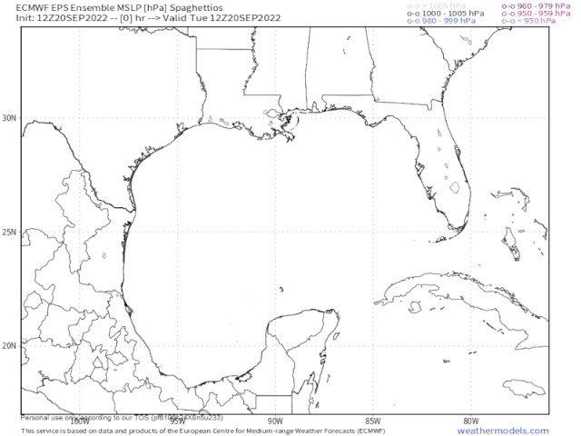
12z EPS completely off the rails
This post was edited on 9/20/22 at 2:55 pm
Posted on 9/20/22 at 2:48 pm to TutHillTiger
Sorry, I was wrong charter boats just confirmed, you are right it’s only 85 in the bay , off shore etc which is normal. We must have been in a patch or something few weeks ago off OB as we were reading 90 all day.
That’s still hot though anything around that can break this up, ramp it down
That’s still hot though anything around that can break this up, ramp it down
Posted on 9/20/22 at 2:48 pm to lsugolfredman
quote:
12z EPS completely off the rails
Completely off the screen, too.
Posted on 9/20/22 at 2:49 pm to Roll Tide Ravens
Looking like a cat 3 Tampa or big bend landfall on the euro
Posted on 9/20/22 at 2:52 pm to LegendInMyMind
yeah that ensemble model just tells me trough timing is everything 
almost everything goes left to right very quickly at some point
almost everything goes left to right very quickly at some point

Posted on 9/20/22 at 2:53 pm to deltaland
Yeah, looks like a bad run for Tampa.
Posted on 9/20/22 at 2:53 pm to gaetti15
I meant that your image wasn't showing up at first.
Posted on 9/20/22 at 2:54 pm to LegendInMyMind
quote:
I meant that your image wasn't showing up at first.
it was also showing something weird like that for me to
like it was showing all the storms going into Yucatan
Posted on 9/20/22 at 2:58 pm to LegendInMyMind
Landfall near or just north of Tampa Thursday night, per this one run of the Euro. Obviously this will change multiple times.

Posted on 9/20/22 at 3:08 pm to Roll Tide Ravens
Also the euro seems to have the cold front stronger and later than the gfs
Posted on 9/20/22 at 3:09 pm to rds dc
A track towards Florida does make sense given the persistence of the Southern Plains Ridge and the projected track of Fiona. However, it's still a long way out there and the 12z EPS highlights multiple potential outcomes.

Posted on 9/20/22 at 3:13 pm to rds dc
While interesting…. id rather have these spaghetti models
Eta: had a feelin a ban hammer was about to cometh
Eta: had a feelin a ban hammer was about to cometh
This post was edited on 9/20/22 at 3:30 pm
Posted on 9/20/22 at 3:16 pm to sonoma8
TYFYS sonoma8, and Godspeed.
Posted on 9/20/22 at 3:17 pm to sonoma8
Hurricanes bring a nip to the air.

Posted on 9/20/22 at 3:19 pm to michael corleone
quote:
Will it pass through Hebert’s box?
Yes, and Bella's vagina.
Posted on 9/20/22 at 3:24 pm to rds dc
Don't love that Western trend. Reminding me of some other storms that shall not be named.
Hopefully it just fizzles into Mexico...
Hopefully it just fizzles into Mexico...
Posted on 9/20/22 at 3:36 pm to rds dc
It looks like the outflow from Fiona will shear 98L over the next couple of days. That should keep the system weaker until it can clear that outflow, which will be dependent on the strength and track of Fiona.

Posted on 9/20/22 at 3:39 pm to rds dc
quote:
looks like the outflow from Fiona will shear 98L over the next couple of days. That should keep the system weaker until it can clear that outflow, which will be dependent on the strength and track of Fiona.
In basic English for us with Ida PTSD
Posted on 9/20/22 at 3:40 pm to rds dc
quote:
That should keep the system weaker until it can clear that outflow, which will be dependent on the strength and track of Fiona.
So because it’ll be weaker that explains the western trends we’ve seen today?

 Page 15 of 465

Popular
Back to top