- My Forums
- Tiger Rant
- LSU Recruiting
- SEC Rant
- Saints Talk
- Pelicans Talk
- More Sports Board
- Fantasy Sports
- Golf Board
- Soccer Board
- O-T Lounge
- Tech Board
- Home/Garden Board
- Outdoor Board
- Health/Fitness Board
- Movie/TV Board
- Book Board
- Music Board
- Political Talk
- Money Talk
- Fark Board
- Gaming Board
- Travel Board
- Food/Drink Board
- Ticket Exchange
- TD Help Board
Customize My Forums- View All Forums
- Show Left Links
- Topic Sort Options
- Trending Topics
- Recent Topics
- Active Topics
Started By
Message
re: Hurricane/Tropical Storm Idalia Discussion Thread
Posted on 8/19/23 at 12:07 pm to LegendInMyMind
Posted on 8/19/23 at 12:07 pm to LegendInMyMind
 1
1

Posted on 8/19/23 at 12:20 pm to NorthEndZone
This round of heat is a little broader to the east. AL, TN, and KY will see higher temps than they have so far this Summer. One thing I like to follow locally (North AL) is which outlet will break and forecast 100° first. It is usually a crapshoot forecasting a borderline 100° day here, and they miss way more than hit. The only other candidate for this Summer ended up missing by several degrees. The first one to make the leap for this coming week is WAFF 48 with 101° and 100° for Wed. and Thurs. No one else has followed yet, not even the NWS.
Let's see who gets it right.
Let's see who gets it right.

Posted on 8/19/23 at 12:40 pm to LegendInMyMind
Pumping all of that vorticity into the upstream portion of the ridge really helps to strengthen it. It also helps to propagate the shortwave trough heading into the Pacific NW downstream and rockets it around the top of the ridge. The ridge finally breaks down somewhat once that trough deepens and sweeps into the Northeast US and we get some height falls in the East.
Posted on 8/19/23 at 12:42 pm to LegendInMyMind
Today is supposed to be OKC hottest day. Its summer but nights get longer and it will break soon enough. The mid/lower 70’s at night help.

Posted on 8/19/23 at 12:48 pm to The Boat
quote:
Pumping all of that vorticity into the upstream portion of the ridge really helps to strengthen it. It also helps to propagate the shortwave trough heading into the Pacific NW downstream and rockets it around the top of the ridge. The ridge finally breaks down somewhat once that trough deepens and sweeps into the Northeast US and we get some height falls in the East.
This trough pattern forming over the eastern US should help keep these numerous disturbances forming in the Atlantic out to sea.
Posted on 8/19/23 at 1:00 pm to The Boat
Looks like the trough is going to send whatever becomes of 90L out to sea. That's a pretty hard right turn for an August Caribbean system, but I'll take it.

This post was edited on 8/19/23 at 1:03 pm
Posted on 8/19/23 at 1:08 pm to The Boat
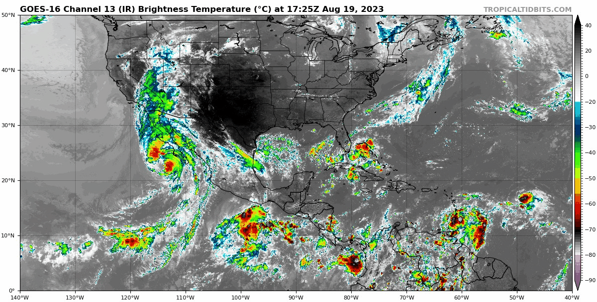
The graphics/video in that tweet thread do a good job of showing what you're talking about.
Posted on 8/19/23 at 1:58 pm to rds dc
That one entering the Gulf looks like a bad go-getter, a mean motor scooter
Posted on 8/19/23 at 2:03 pm to tarzana
For east Alabama Next 7 day high forecast: 94, 94, 98, 100, 98, 99, 99 with negligible chance of rain.
Posted on 8/19/23 at 2:04 pm to Mr Breeze
quote:
GoM waters are warm this summer
Yea, they're warmer than normal, but not as hot as they'll be about a month from today. We've just kicked off; the pitch is hot
Posted on 8/19/23 at 2:08 pm to Jmcc64
The south Texas/Mexico coast appears to be the target for next week's system. The bone-dry oven-hot lands to the north and east will just continue to bake--sheesh.
Posted on 8/19/23 at 2:11 pm to tarzana
So I should man the sprinklers all next week and try to save what I can of my desert front yard now? I mean shite, I even tried to cut the grass much higher than normal and as soon as I did it decided everywhere it's going to die. frick this heat. I'll take it over a hurricane though.
This post was edited on 8/19/23 at 2:13 pm
Posted on 8/19/23 at 2:13 pm to NorthEndZone
I know this season has been anything but normal but I have a hard time believing it takes that hard NNE turn. Historically this time of the year it wouldn’t make that hard turn but time will tell I guess
Posted on 8/19/23 at 2:37 pm to SWLA92
When do rain chances start coming back?
Posted on 8/19/23 at 2:41 pm to NorthEndZone
Obviously, if that 600dm ridge sets up and remains parked over the Mississippi Valley, the northern Gulf Coast is closed for business and the downstream trough will send everything out towards Bermuda or the Azores
This post was edited on 8/19/23 at 2:43 pm
Posted on 8/19/23 at 2:45 pm to tarzana
quote:
The south Texas/Mexico coast appears to be the target for next week's system. The bone-dry oven-hot lands to the north and east will just continue to bake--sheesh.
I'm to the north and east and my area isn't bone dry and baking. Stop generalizing your hysteria. Or, just stop completely.
Posted on 8/19/23 at 2:52 pm to LegendInMyMind
We are baking here in Central Mississippi. Grass is all brown. People with cows are about to get in trouble.
Posted on 8/19/23 at 2:53 pm to Allthatfades
quote:
People with cows are about to get in trouble.
mmm medium rare sun baked cow
Posted on 8/19/23 at 2:53 pm to LegendInMyMind
quote:
National Hurricane Center
@NHC_Atlantic
2pm EDT Sat 19 August: There are now 5 systems we are currently monitoring in the NATL basin for TC formation.
Of these features, both Invest #90L near the Windward Islands & another system near the Bahamas pose a risk of land impacts.


 Page 20 of 139

Popular
Back to top