




- My Forums
- Tiger Rant
- LSU Recruiting
- SEC Rant
- Saints Talk
- Pelicans Talk
- More Sports Board
- Fantasy Sports
- Golf Board
- Soccer Board
- O-T Lounge
- Tech Board
- Home/Garden Board
- Outdoor Board
- Health/Fitness Board
- Movie/TV Board
- Book Board
- Music Board
- Political Talk
- Money Talk
- Fark Board
- Gaming Board
- Travel Board
- Food/Drink Board
- Ticket Exchange
- TD Help Board
Customize My Forums- View All Forums
- Show Left Links
- Topic Sort Options
- Trending Topics
- Recent Topics
- Active Topics
Started By
Message
re: Storm Tracking: Bertha - It's Over
Posted on 7/20/26 at 9:43 am to Darth_Vader

Posted on 7/20/26 at 9:43 am to Darth_Vader
Make sure to post any fights on world star
 1
1



Posted on 7/20/26 at 9:43 am to Cosmo
quote:
Its not strong enough to do anything except raise tides slightly
Are you saying I should go ahead and get a jump on things and cut out the bottom 2' of sheetrock now?
Posted on 7/20/26 at 9:46 am to Weekend Warrior79
Probably so. They have been wrong on every forecast except “it’s hot” this year
Posted on 7/20/26 at 9:50 am to LSU Neil
What time is the next update? 10am central?


Posted on 7/20/26 at 9:52 am to Spocks Brain
Tropical Depression Two Advisory Number 5
NWS National Hurricane Center Miami FL AL022026
1000 AM CDT Mon Jul 20 2026
...DEPRESSION GETTING BETTER ORGANIZED...
...NEW WATCHES ISSUED FOR PORTIONS OF THE GULF COAST...
SUMMARY OF 1000 AM CDT...1500 UTC...INFORMATION
-----------------------------------------------
LOCATION...28.5N 85.6W
ABOUT 120 MI...190 KM S OF PANAMA CITY FLORIDA
ABOUT 215 MI...345 KM SE OF MOBILE ALABAMA
MAXIMUM SUSTAINED WINDS...35 MPH...55 KM/H
PRESENT MOVEMENT...NW OR 310 DEGREES AT 3 MPH...6 KM/H
MINIMUM CENTRAL PRESSURE...1007 MB...29.74 INCHES
WATCHES AND WARNINGS
--------------------
CHANGES WITH THIS ADVISORY:
A Storm Surge Watch has been issued for the U.S. Gulf Coast from
the Alabama/Florida Border to the Mouth of the Mississippi River,
Louisiana.
A Tropical Storm Watch has been issued for the coasts of
Mississippi and Louisiana from the Mississippi/Alabama border to
the Jefferson/Plaquemines parish border.
SUMMARY OF WATCHES AND WARNINGS IN EFFECT:
A Storm Surge Watch is in effect for...
* Alabama/Florida Border to the Mouth of the Mississippi River
A Tropical Storm Watch is in effect for...
* Ochlockonee River Florida westward to the Jefferson/Plaquemines
Parish border in Louisiana.
A Storm Surge Watch means there is a possibility of life-
threatening inundation, from rising water moving inland from the
coastline, in the indicated locations during the next 48 hours.
For a depiction of areas at risk, please see the National Weather
Service Storm Surge Watch/Warning Graphic, available at
hurricanes.gov.
A Tropical Storm Watch means that tropical storm conditions are
possible within the watch area, in this case in the next 24 to 48
hours.
Additional watches or warnings may be required later today or
Tuesday.
For storm information specific to your area, including possible
inland watches and warnings, please monitor products issued by your
local National Weather Service forecast office.
DISCUSSION AND OUTLOOK
----------------------
At 1000 AM CDT (1500 UTC), the center of Tropical Depression Two was
located near latitude 28.5 North, longitude 85.6 West. The
depression is moving erratically toward the northwest near 3 mph (6
km/h). A slow northwestward motion is expected through tonight,
followed by a turn toward the west-northwest or west. On the
forecast track, the depression will move near or along the northern
Gulf coast during the next several days.
Maximum sustained winds are near 35 mph (55 km/h) with higher gusts.
Satellite imagery and coastal Doppler radar data indicate that the
depression is getting better organized, and it is expected to
become a tropical storm later today. After that, additional
gradual strengthening is expected through Tuesday.
The minimum central pressure estimated from a combination of Air
Force Reserve Hurricane Hunter aircraft data and surface
observations is 1007 mb (29.74 inches).
HAZARDS AFFECTING LAND
----------------------
Key messages for Tropical Depression Two can be found in the
Tropical Cyclone Discussion under AWIPS header MIATCDAT2 and WMO
header WTNT42 KNHC.
WIND: Tropical storm conditions are possible within the watch
area in the Florida Panhandle by late tonight into Tuesday. Tropical
storm conditions are possible within the remainder of the watch
area by late Tuesday night into Wednesday.
STORM SURGE: The combination of storm surge and the tide will
cause normally dry areas near the immediate coast to be flooded by
rising waters moving inland from the shoreline. The water could
reach the following heights above ground somewhere in the indicated
areas if the peak surge occurs at the time of high tide...
Mouth of the Mississippi River, LA to AL/FL Border...2-4 ft
Indian Pass, FL to Chassahowitzka, FL...1-3 ft
Morgan City, LA to Mouth of the Mississippi River, LA...1-3 ft
Lake Pontchartrain...1-3 ft
The deepest water will occur along the immediate coast.
Surge-related flooding depends on the relative timing of the surge
and the tidal cycle, and can vary greatly over short distances. For
information specific to your area, please see products issued by
your local National Weather Service forecast office.
For a complete depiction of areas at risk of storm surge
inundation, please see the National Weather Service Peak
Storm Surge Graphic, available at
hurricanes.gov/graphics_at2.shtml?peakSurge.
RAINFALL: The tropical depression is expected to produce rainfall
amounts of 2 to 4 inches with isolated higher totals around 8 inches
through Friday along the Gulf Coast and adjacent inland locations
from western Florida to the Middle Texas Coast, including southern
portions of Alabama, Mississippi, and Louisiana. This rainfall may
produce areas of flash flooding, especially in urban areas.
For a complete depiction of forecast rainfall associated with
Tropical Depression Two, please see the National Weather Service
Storm Total Rainfall Graphic available at
hurricanes.gov/graphics_at2.shtml?rainqpf and the Flash Flood Risk
graphic at hurricanes.gov/graphics_at2.shtml?ero.
TORNADOES: An isolated tornado or two are possible over the Florida
Big Bend region today.
SURF: Swells generated by the depression are affecting portions of
the Gulf coast of Florida and are likely to spread westward during
the week. These swells are likely to cause life-threatening surf
and rip current conditions. Please consult products from your
local weather office.
A depiction of rip current risk for the United States can be found
at: hurricanes.gov/graphics_at2.shtml?ripCurrents
NEXT ADVISORY
-------------
Next intermediate advisory at 100 PM CDT.
Next complete advisory at 400 PM CDT.
$$
Forecaster Beven
NWS National Hurricane Center Miami FL AL022026
1000 AM CDT Mon Jul 20 2026
...DEPRESSION GETTING BETTER ORGANIZED...
...NEW WATCHES ISSUED FOR PORTIONS OF THE GULF COAST...
SUMMARY OF 1000 AM CDT...1500 UTC...INFORMATION
-----------------------------------------------
LOCATION...28.5N 85.6W
ABOUT 120 MI...190 KM S OF PANAMA CITY FLORIDA
ABOUT 215 MI...345 KM SE OF MOBILE ALABAMA
MAXIMUM SUSTAINED WINDS...35 MPH...55 KM/H
PRESENT MOVEMENT...NW OR 310 DEGREES AT 3 MPH...6 KM/H
MINIMUM CENTRAL PRESSURE...1007 MB...29.74 INCHES
WATCHES AND WARNINGS
--------------------
CHANGES WITH THIS ADVISORY:
A Storm Surge Watch has been issued for the U.S. Gulf Coast from
the Alabama/Florida Border to the Mouth of the Mississippi River,
Louisiana.
A Tropical Storm Watch has been issued for the coasts of
Mississippi and Louisiana from the Mississippi/Alabama border to
the Jefferson/Plaquemines parish border.
SUMMARY OF WATCHES AND WARNINGS IN EFFECT:
A Storm Surge Watch is in effect for...
* Alabama/Florida Border to the Mouth of the Mississippi River
A Tropical Storm Watch is in effect for...
* Ochlockonee River Florida westward to the Jefferson/Plaquemines
Parish border in Louisiana.
A Storm Surge Watch means there is a possibility of life-
threatening inundation, from rising water moving inland from the
coastline, in the indicated locations during the next 48 hours.
For a depiction of areas at risk, please see the National Weather
Service Storm Surge Watch/Warning Graphic, available at
hurricanes.gov.
A Tropical Storm Watch means that tropical storm conditions are
possible within the watch area, in this case in the next 24 to 48
hours.
Additional watches or warnings may be required later today or
Tuesday.
For storm information specific to your area, including possible
inland watches and warnings, please monitor products issued by your
local National Weather Service forecast office.
DISCUSSION AND OUTLOOK
----------------------
At 1000 AM CDT (1500 UTC), the center of Tropical Depression Two was
located near latitude 28.5 North, longitude 85.6 West. The
depression is moving erratically toward the northwest near 3 mph (6
km/h). A slow northwestward motion is expected through tonight,
followed by a turn toward the west-northwest or west. On the
forecast track, the depression will move near or along the northern
Gulf coast during the next several days.
Maximum sustained winds are near 35 mph (55 km/h) with higher gusts.
Satellite imagery and coastal Doppler radar data indicate that the
depression is getting better organized, and it is expected to
become a tropical storm later today. After that, additional
gradual strengthening is expected through Tuesday.
The minimum central pressure estimated from a combination of Air
Force Reserve Hurricane Hunter aircraft data and surface
observations is 1007 mb (29.74 inches).
HAZARDS AFFECTING LAND
----------------------
Key messages for Tropical Depression Two can be found in the
Tropical Cyclone Discussion under AWIPS header MIATCDAT2 and WMO
header WTNT42 KNHC.
WIND: Tropical storm conditions are possible within the watch
area in the Florida Panhandle by late tonight into Tuesday. Tropical
storm conditions are possible within the remainder of the watch
area by late Tuesday night into Wednesday.
STORM SURGE: The combination of storm surge and the tide will
cause normally dry areas near the immediate coast to be flooded by
rising waters moving inland from the shoreline. The water could
reach the following heights above ground somewhere in the indicated
areas if the peak surge occurs at the time of high tide...
Mouth of the Mississippi River, LA to AL/FL Border...2-4 ft
Indian Pass, FL to Chassahowitzka, FL...1-3 ft
Morgan City, LA to Mouth of the Mississippi River, LA...1-3 ft
Lake Pontchartrain...1-3 ft
The deepest water will occur along the immediate coast.
Surge-related flooding depends on the relative timing of the surge
and the tidal cycle, and can vary greatly over short distances. For
information specific to your area, please see products issued by
your local National Weather Service forecast office.
For a complete depiction of areas at risk of storm surge
inundation, please see the National Weather Service Peak
Storm Surge Graphic, available at
hurricanes.gov/graphics_at2.shtml?peakSurge.
RAINFALL: The tropical depression is expected to produce rainfall
amounts of 2 to 4 inches with isolated higher totals around 8 inches
through Friday along the Gulf Coast and adjacent inland locations
from western Florida to the Middle Texas Coast, including southern
portions of Alabama, Mississippi, and Louisiana. This rainfall may
produce areas of flash flooding, especially in urban areas.
For a complete depiction of forecast rainfall associated with
Tropical Depression Two, please see the National Weather Service
Storm Total Rainfall Graphic available at
hurricanes.gov/graphics_at2.shtml?rainqpf and the Flash Flood Risk
graphic at hurricanes.gov/graphics_at2.shtml?ero.
TORNADOES: An isolated tornado or two are possible over the Florida
Big Bend region today.
SURF: Swells generated by the depression are affecting portions of
the Gulf coast of Florida and are likely to spread westward during
the week. These swells are likely to cause life-threatening surf
and rip current conditions. Please consult products from your
local weather office.
A depiction of rip current risk for the United States can be found
at: hurricanes.gov/graphics_at2.shtml?ripCurrents
NEXT ADVISORY
-------------
Next intermediate advisory at 100 PM CDT.
Next complete advisory at 400 PM CDT.
$$
Forecaster Beven
Posted on 7/20/26 at 10:19 am to LSU Neil
They are wrong on that, too. It’s hot as h*ll vs just hot.


Posted on 7/20/26 at 10:30 am to deltaland
quote:
Make sure to post any fights on TD
Posted on 7/20/26 at 10:31 am to Darth_Vader
quote:
Carnival Liberty for the next 7 days.
(Yeah, I’m trashy. Zero fricks given)
Had a great cruise on the Liberty over Mardi Gras. Also, saw yall loading up when we flew over the city heading home yesterday. Hope the weather isn't too rough for you.

Posted on 7/20/26 at 10:34 am to Cosmo
Yall better stay on topic or Spocks Brain is going to be upset
Posted on 7/20/26 at 10:38 am to VanRIch
Cut me some slack! This is a big meeting!

Posted on 7/20/26 at 10:48 am to Ziggy
Ive landed at MSY during a tropical storm in the area 10-12 years ago. Don’t think that could happen again with current rules and regulations.
Good luck.
Atlanta shut down yesterday while we were passing thru. Resulting in total chaos. We only had an 8 hour delay after we were 30 minutes from boarding with plane snd crew there. After the rain, no plane and no crew.
Good luck.
Atlanta shut down yesterday while we were passing thru. Resulting in total chaos. We only had an 8 hour delay after we were 30 minutes from boarding with plane snd crew there. After the rain, no plane and no crew.


Posted on 7/20/26 at 10:58 am to Darth_Vader
quote:
Carnival Liberty for the next 7 days.
(Yeah, I’m trashy. Zero fricks given)
I saw someone I know post on Facebook that they were on the same ship this week, and I thought to myself, enjoy your trashy cruise
Go around asking everyone if they know me and let me know if you find them. His name is Jeremy.
This post was edited on 7/20/26 at 10:59 am

Posted on 7/20/26 at 10:59 am to stout
looks like my wife and I's move from Bham to Kerrville tx the end of the week is gonna be fun

Posted on 7/20/26 at 11:02 am to Darth_Vader
quote:
Carnival Liberty for the next 7 days.
Did the same cruise a few weeks ago. Rented a golf cart in Key West and did some sight seeing. That was pretty cool.

Posted on 7/20/26 at 11:43 am to Archives
(no message)

Posted on 7/20/26 at 11:57 am to LSU Tiger Eyes
Attention New Orleans Residents. Queen Moreno made some sandbags for you because the pumps don’t work.


Posted on 7/20/26 at 12:00 pm to JonTheTigerFan
quote:
Did the same cruise a few weeks ago. Rented a golf cart in Key West and did some sight seeing. That was pretty cool.
I think we’re doing the aquarium and a glass bottom boat. If there is time Mrs. Vader and our daughter want to do some shopping of course.


Posted on 7/20/26 at 12:05 pm to rds dc
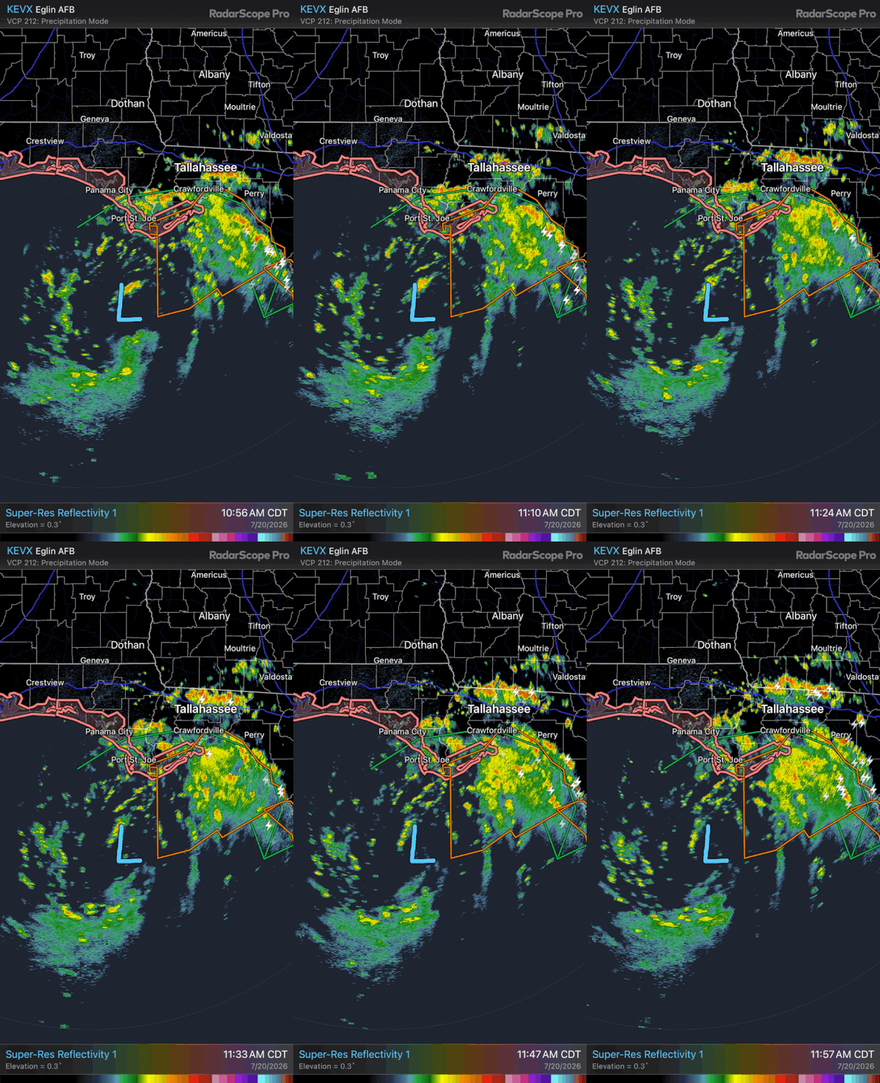
A look at TD2 on radar (about noon CDT).


Posted on 7/20/26 at 12:11 pm to Darth_Vader
quote:
glass bottom boat
ewwwwwwww

Posted on 7/20/26 at 12:16 pm to Roll Tide Ravens
St George Island has been getting pounded for almost 18 hours now.

 Page 14 of 38

Popular
Back to top
 Follow TigerDroppings for LSU Football News